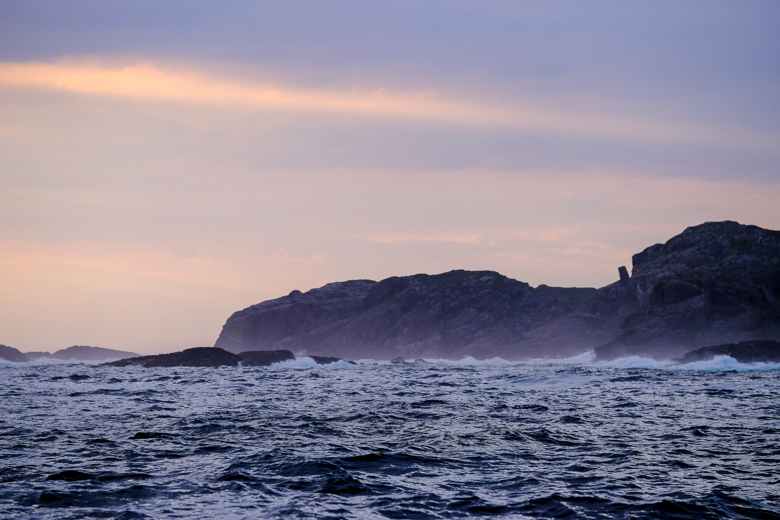
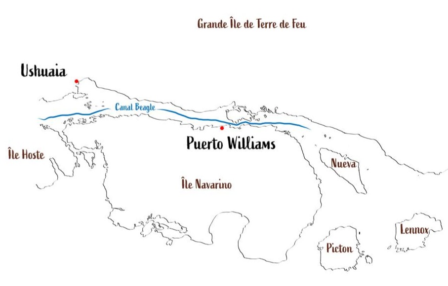
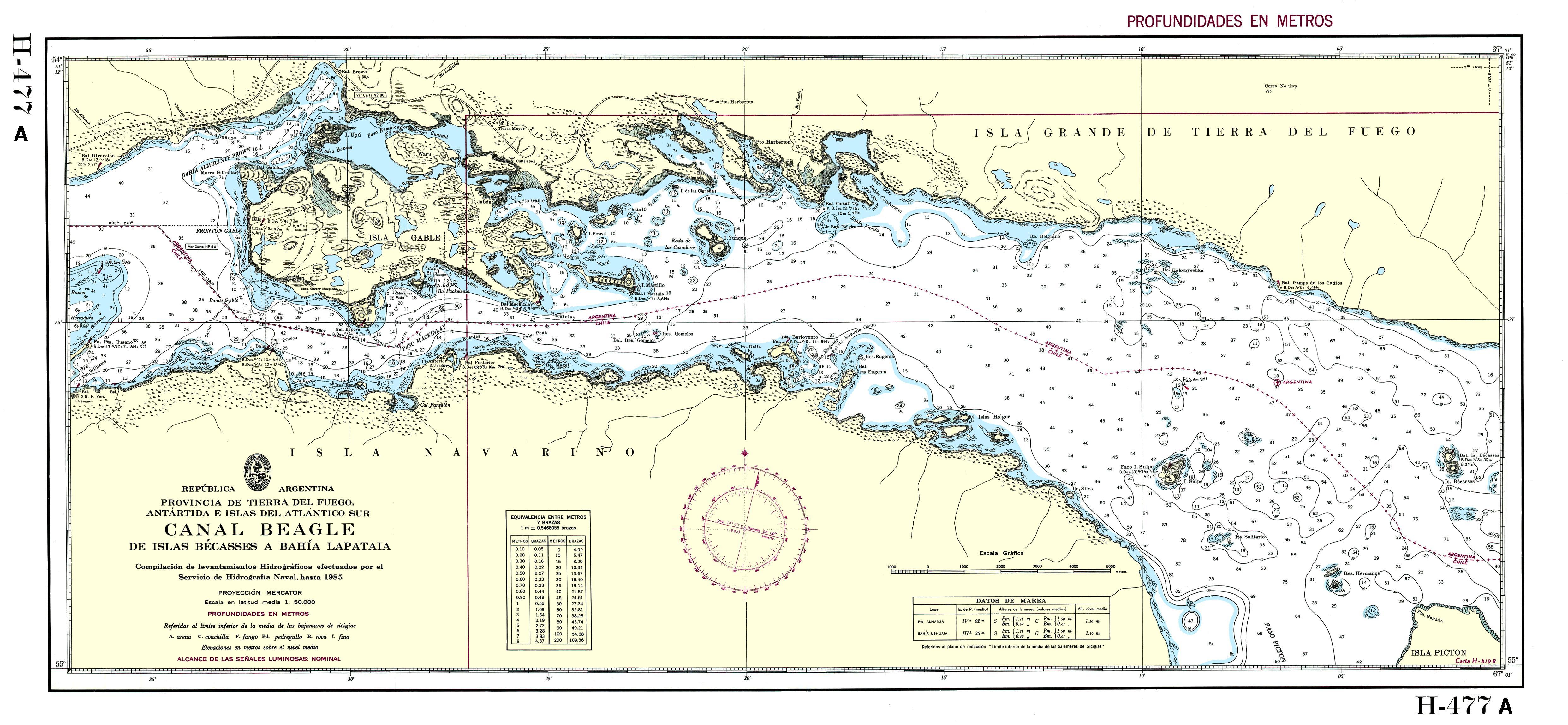
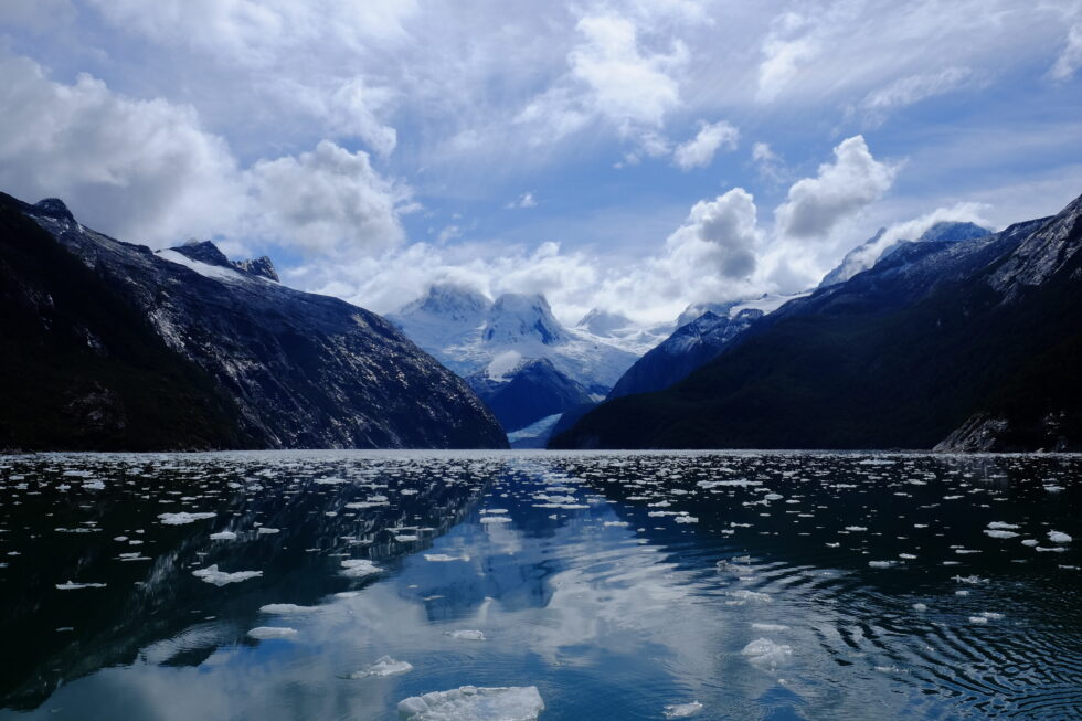
The Beagle Channel, known to the Yaghan people as Onashaga (“channel of the Ona hunters,” i.e., their Selk'nam neighbors from Tierra del Fuego), is one of the planet’s outstanding maritime passages. This interoceanic strait, approximately 270 kilometers long, connects the Atlantic and Pacific oceans at the very southern tip of South America, separating the main island of Tierra del Fuego from an archipelago of smaller islands between 54°50′ and 55°00′ south latitude.
The east part of the Beagle channel (c) Karukinka
For us, who regularly sail these legendary waters, Onashaga—the Beagle Channel—means much more than a simple maritime passage: it’s a world of its own, where two oceans meet and where seven millennia of Yagan navigation still resonate.
Table des matières
The genesis of the landscape: a glacial heritage
When ice sculpted the channels
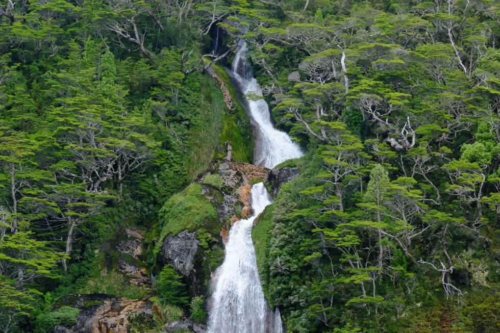
The formation of the Beagle Channel is a prime example of Quaternary glacial sculpting, which has shaped one of the most spectacular southern hemisphere landscapes. During repeated Pleistocene glaciations, glaciers hundreds of meters thick excavated valleys like Carbajal and Lake Kami (Fagnano), creating the region’s complex topography.
Photography of the Carbajal Valley by Lauriane Lemasson, during the 2013 expedition in Argentine Tierra del Fuego
The glacier responsible for forming the Beagle Canal moved from west to east, fed by the Darwin Range, where glaciers and snowfields—remnants of this genesis—can still be seen today. This glacial process left behind moraine deposits in the shallower areas, especially around Gable Island and off the Ushuaia Bay, creating today's bathymetric complexities.
The tectonic structure underlying the channel is a longitudinal tectonic valley, later modified by glacial action. The combination of tectonic and glacial processes resulted in a morphology with semi-isolated basins as deep as 400 meters, separated by shallow topographic sills that control water mass circulation.
A complex submarine architecture
The Beagle Channel’s bathymetry reveals a complex architecture dominated by a series of shallow sills, dividing the channel into several distinct micro-environments. In the western sector, the Diablo Island sill (approx. 50 meters deep) and the Fleuriais Bay sill (about 100 meters) separate the northwestern and southwestern branches from the central sector.
This bathymetric setup generates a complex circulation system, with sills acting as barriers that limit the exchange of deep water masses, creating micro-environments with distinctive physical, chemical, and biological properties.
It is this diversity of habitats that makes the Beagle Channel such a rich and unique ecosystem, as explained by Centro IDEAL researchers who have studied these waters for years.
East part of the Beagle channel
Hydrographic system
The meeting of oceans
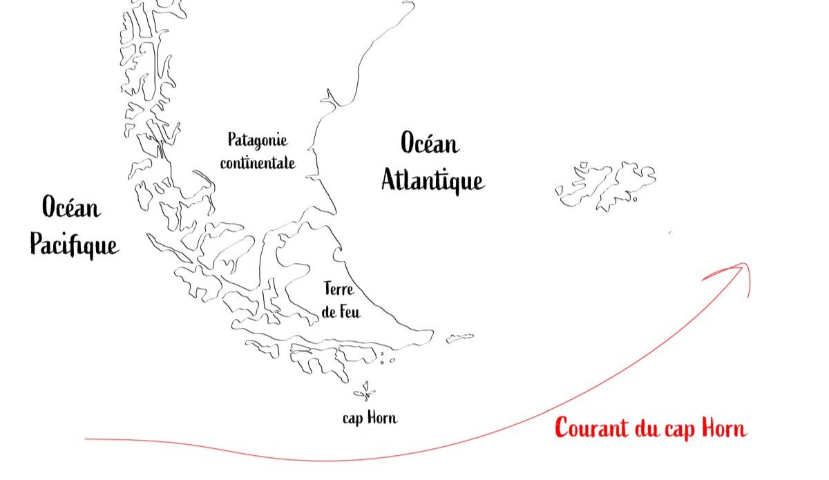
The Beagle Canal acts as an interoceanic corridor that facilitates the transport of surface waters from the Pacific to the Atlantic, a flow mainly driven by the difference in sea level between the two oceans and the influence of strong westerly winds within the Antarctic Circumpolar Current.
The Cape Horn current is the primary source of water entering the channel, bringing subantarctic water (SAAW) at depths greater than 100 meters along the edge of the Patagonian Pacific shelf. This water enters via a submarine canyon at the western mouth of the channel, characterized by temperatures of 8–9°C, salinity above 33, and relatively low oxygen concentrations.
Map illustrating the Cape Horn current (c) Karukinka
Waters that tell the story of the climate
Freshwater input from the Darwin Cordillera icefield generates a two-layer system, with a pronounced pycnocline separating vertical phytoplankton fluorescence. This estuarine water is cold (4–6°C), nutrient-poor, and highly oxygenated.
Time series analyses reveal that the annual cycle explains 75–89% of ocean temperature variability, while the atmospheric cycle explains 53% of its variability.
These data allow us to understand how the channel reacts to climate change, emphasize oceanographers monitoring these waters.
A sanctuary for marine biodiversity
The realm of marine mammals
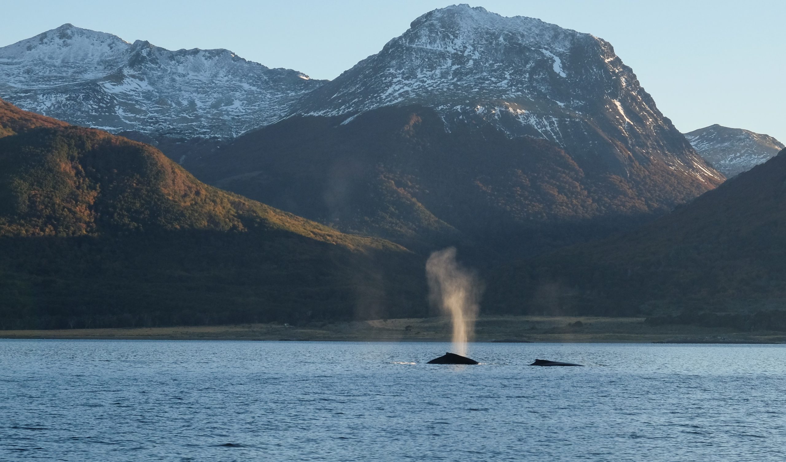
The channel hosts an exceptional diversity of marine mammals, internationally recognized as an important marine mammal area (IMMA), covering 26,572 km² from the channel to Cape Horn. This area is home to at least eleven primary marine mammal species, plus eight supporting species.
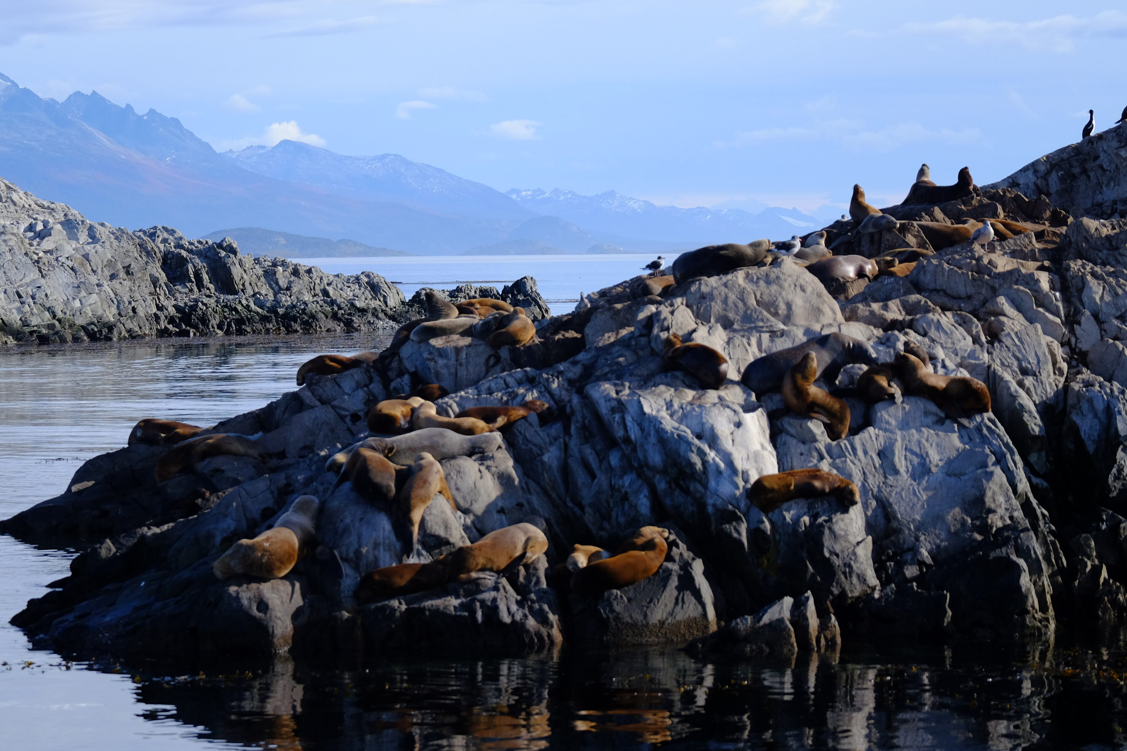
Among the year-round resident species are three small cetaceans: the Peale’s dolphin (Lagenorhynchus australis), the dusky dolphin (L. obscurus), and the Burmeister’s porpoise (Phocoena spinipinnis), along with two pinnipeds: the South American sea lion (Otaria byronia) and the South American fur seal (Arctocephalus australis).
Colony of South American fur seals in the Beagle Channel, near Ushuaia Bay, photographed in April 2025 during a sailing expedition
We have had the chance to observe these Peale’s dolphins during our voyages across Patagonia’s channels, from the channel’s eastern mouth to Cook Bay at its southwestern end. Their close association with kelp forests is fascinating: they undertake 40.5% of their feeding and 14.3% of their hunting behaviors there.
The underwater kelp forests
The underwater forests of Macrocystis pyrifera, locally known as “cachiyuyos,” are among the channel’s most important ecosystems, extending from the Valdés Peninsula to Tierra del Fuego. These forests provide a critical habitat, acting as nursery grounds, refuges, and feeding areas for an exceptionally diverse range of marine species.
Doctoral research by Adriana Milena Cruz Jiménez revealed the complexity of fish assemblages associated with these forests, examining various strata: the lower area at the holdfast and the mid-water area at the fronds.
The ichthyological diversity found in these kelp forests highlights their vital role in marine biodiversity, explains this specialist.
A delicate balance under threat
The pattern of nutrient distribution in the Beagle Channel varies distinctly among its water masses. The system is notably nitrate-limited, with an N:P ratio of 8.42, consistent across all water masses. This directly influences the channel’s primary productivity.
Phytoplankton biomass is generally moderate and limited to the upper pycnocline in the western sector, while mixing over sills disrupts stratification, pushing phytoplankton cells beneath the photic zone, which can limit primary production.
Local scientists insist that understanding these mechanisms is crucial to preserving the unique balance of this ecosystem.
The Yagan cultural heritage: the Onashaga (Beagle) Channel
Seven millennia of navigation
The name Onashaga means “channel of the Ona hunters” in the Yagan language and reflects the profound connection between this maritime people and these waters for around 7,000 years. The Yagan developed a nomadic culture based entirely on exploiting marine resources and constant navigation of the Fuegian archipelago, adapting to an environment Europeans found utterly inhospitable.
When we sail these waters, we still feel the presence of those ancient navigators, as our crew members testify. Their traditional territory extended from the southern coast of the main Tierra del Fuego island (Onaisin) to the Cape Horn archipelago, including the Onashaga. This toponym is one of the many native place names erased from official maps by colonization, which we must now reclaim to restore meaning rooted in the land’s first inhabitants.
The channel as an archaeological witness
Archaeological evidence along the Beagle Channel reveals human occupation stretching back millennia, with shell middens, lithic tool workshops, fish traps, and ancient campsites.
Notable archaeological sites include evidence of ancient Yagan settlement at places like Wulaia Bay on Navarino Island, indicating occupation over 7,000 years ago.
The legacy of great explorations
In the footsteps of Darwin and FitzRoy
The channel is named after HMS Beagle, the British ship that conducted the first hydrographic survey of southern South America’s coasts from 1826 to 1830. The European discovery of the channel occurred in April 1830, when the Beagle was anchored in Orange Bay (southeast Hoste Island).
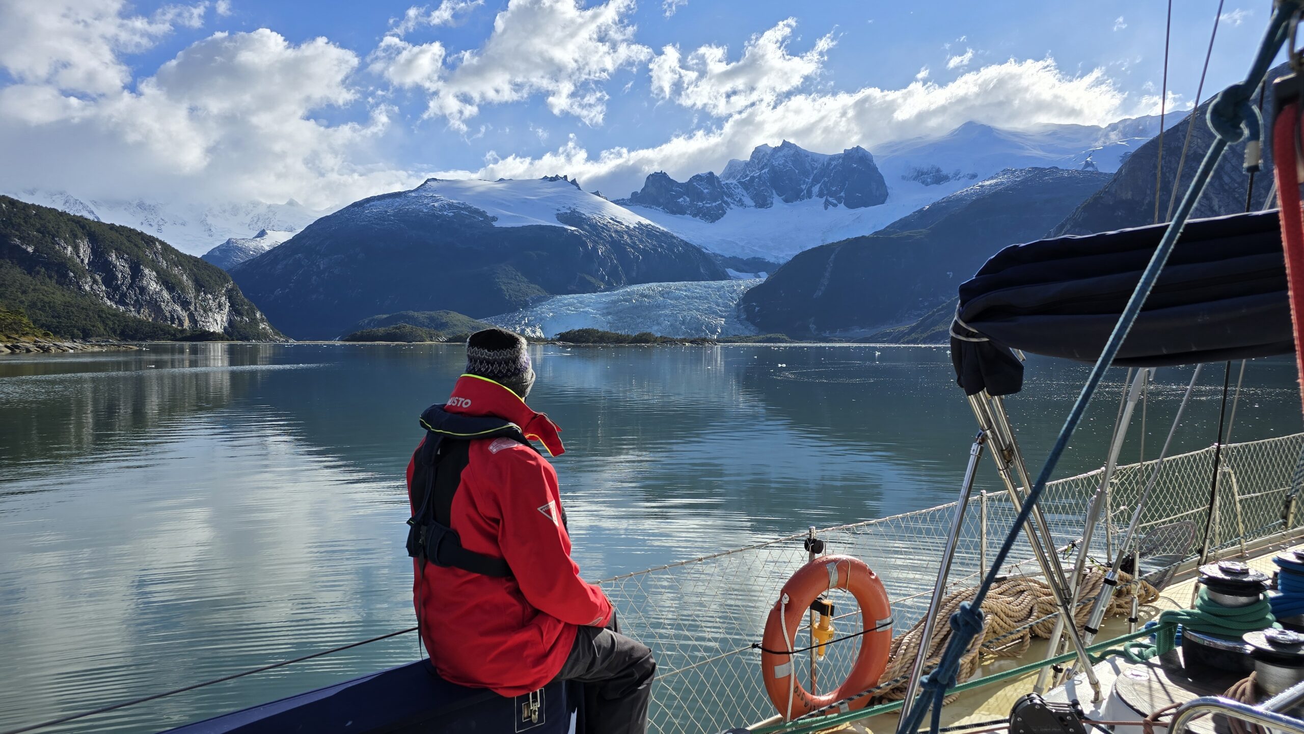
During the second expedition (1831–1836), FitzRoy brought along Charles Darwin as a self-financed naturalist. Darwin saw his first glaciers there in January 1833, writing in his journal: “It is almost impossible to imagine anything more beautiful than the beryl-blue of these glaciers, especially contrasted with the dead white of the upper snow stretches.”
And to travel there regularly... it is always a wonder! Patagonia sailing expedition, February 2025 (Karukinka)
Darwin’s meticulous observations of the region’s geology, fauna, and indigenous populations provided key evidence for his understanding of adaptation and geographic species distribution.
The channel thus became one of the seminal natural laboratories in the history of natural sciences.
From mapping to geopolitical conflict
The hydrographic surveys by Captain FitzRoy and crew laid the groundwork for modern navigation in the region, followed by those from the Cape Horn Scientific Mission. However, this mapping precision also revealed the strategic importance of the channel, which would become a historic source of geopolitical tensions between Chile and Argentina.
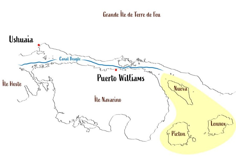
The Beagle conflict of 1978 brought the nations to the brink of war over three small islands—Picton, Lennox, and Nueva—whose sovereignty would determine control over vast maritime territories. The dispute was resolved by papal mediation, with Pope John Paul II playing a crucial role, leading to the treaty of peace and friendship of 1984.
In yellow, the islands involved in the Beagle Conflict of 1978
Modern science in the service of knowledge
A monitored natural laboratory
Today, the channel is one of the best-studied subantarctic marine systems, serving as a comprehensive regional sentinel of global change. Since October 2016, Chile’s Austral University’s Centro IDEAL has conducted annual hydrographic transects from the western end to Yendegaia Bay.
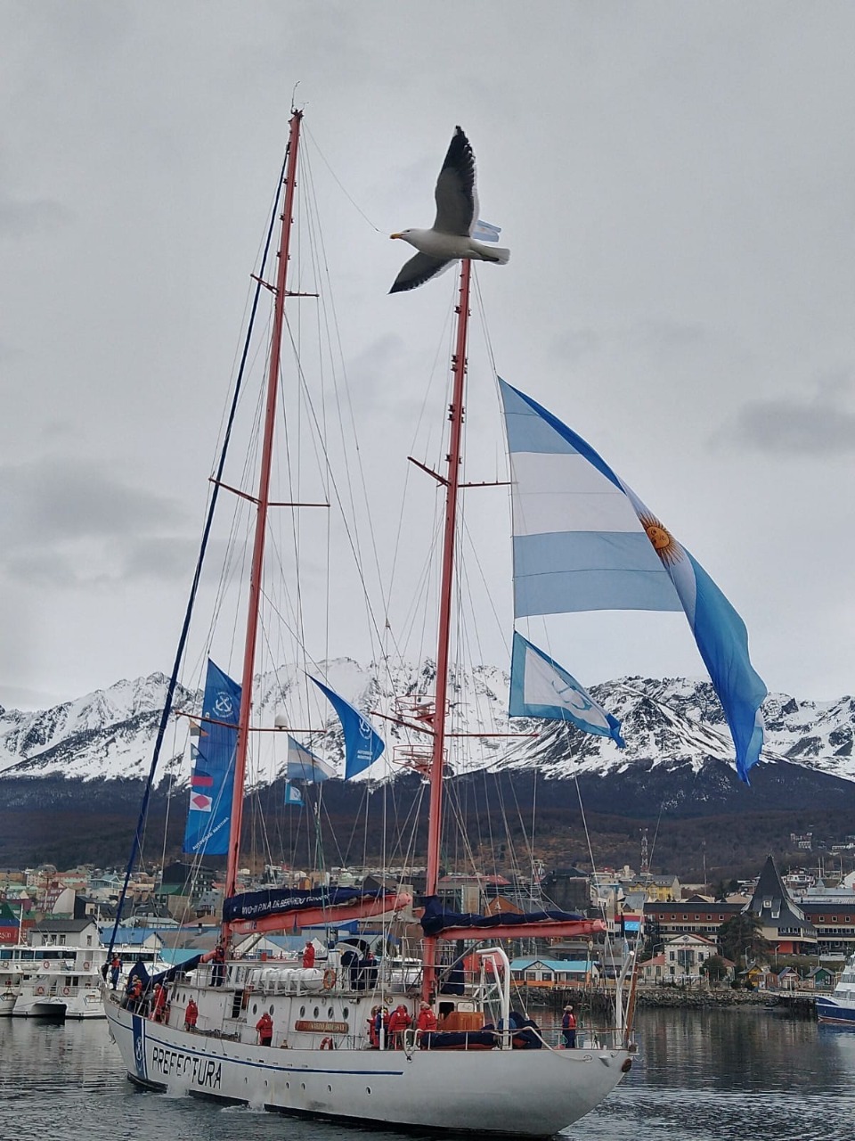
A major milestone was achieved in July–August 2017 with the first complete, high-resolution oceanographic survey along the entire channel, carried out through cooperation between Centro IDEAL and an Argentine expedition on the research vessel Bernardo Houssay. This international collaboration generated, for the first time, a complete hydrographic section of the channel, say the researchers involved.
The sailing vessel Bernardo Houssay, of the Argentine Naval Prefecture, upon its arrival at the port of Ushuaia in 2021 (source)
Unique scientific challenges
Research in the Beagle Channel faces unique challenges due to its remote location, complex geomorphology, and shared jurisdiction between Chile and Argentina, historically limiting coordinated research. Future needs include studies on processes within each semi-enclosed basin and implementation of coupled atmosphere-ocean-glacier models to determine residence times.
Such research is crucial to understanding how this ecosystem will respond to future climate change.
Threats and conservation issues
The challenges of climate change
This channel faces unprecedented threats from climate change: rising temperatures, shifting precipitation patterns, and ocean acidification, all threatening the ecosystem’s delicate balance. Glacier retreat has accelerated dramatically in recent decades, altering freshwater contributions and potentially affecting marine productivity.
Changes have already been observed during our expeditions: the retreat of glaciers between 2018 and 2025 left a lasting impression. Scientists closely monitor these changes, using the region as a natural laboratory to understand wider impacts of climate change.
The salmon farming controversy
The expansion of the salmon farming industry into the region has been categorically rejected by organizations grouped within the Forum for the Conservation of the Patagonian Sea, which express concern over potentially catastrophic and irreversible damage to one of the region’s most precious marine ecosystems.
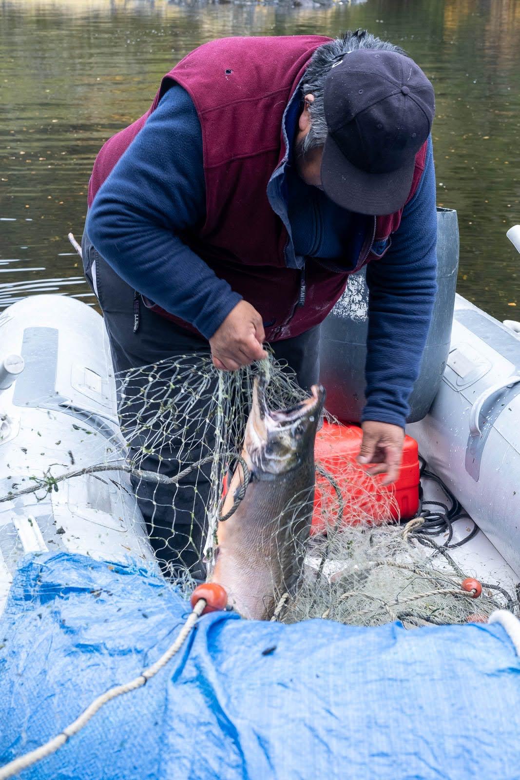
We strongly support this position: the channel’s pristine waters are home to one of the world’s greatest biodiversity reserves, with great heterogeneity in coastal-marine habitats containing numerous understudied marine invertebrates and vertebrates. Introduction of non-native species such as salmon is considered “terrible and risky” for this ecosystem by leading researchers. Fish-farm salmon escapes upstream have led to “wild salmon” appearing in the Cape Horn Biosphere Reserve, now threatening endemic species such as robalo.
An example of a salmon caught by José near the northern arm of the Beagle Channel during one of our sailing expeditions in 2025 (photo Christine Stein, Karukinka Association
A challenge of international and multicultural preservation and cooperation
Since 2005, in order to preserve this natural marvel, most islands south of the Beagle are part of the Cape Horn Biosphere Reserve, managed by UNESCO, CONAF, and the Chilean Navy. This designation acknowledges the ecosystem's outstanding importance and establishes long-term conservation frameworks.
We believe that preserving Yagan culture and integrating their ancestral knowledge is essential to understanding and protecting this unique ecosystem. Including Yagan traditional ecological knowledge in contemporary environmental management represents an opportunity to develop innovative approaches to conservation. Knowledge of navigation, climate observation, marine resources, and seasonal cycles forms a scientific heritage of great value, complementing modern research methodologies.
Bibliography
Scientific sources
Ferreyra, G. & González, H. “General hydrography of the Beagle Channel, a subantarctic interoceanic passage at the southern tip of South America.” Frontiers in Marine Science, September 30, 2021.
Marine Mammal Protected Areas Task Force. “Beagle Channel to Cape Horn IMMA – Marine Mammal Protected Areas Task Force.” Marine Mammal Habitat, March 18, 2024.
Lodolo, E., Menichetti, M. & Tassone, A. “Shallow architecture of Fuegian Andes lineaments based on marine geophysical data.” Andean Geology, vol. 45, no. 1, 2018.
Institutional publications
Yaghan’s, explorers and settlers.Museo Yaganusi, Government of Chile. PDF document, 2021.
Canal Beagle sin salmoneras.Mar Patagónico, regional declaration, 2024.
The Beagle Channel free from salmon farming.Mar Patagónico, regional statement, 2024.
Phytoplankton biodiversity and water quality in the Beagle Channel, Argentina, 2017–2021.Government of Argentina, PDF document.
Articles
El Rompehielos. “The importance of marine biodiversity in the Beagle Channel.” January 29, 2020.
Radio del Mar. “Beagle Channel is a key research ecosystem for marine biology.” May 22, 2023.
Centro IDEAL. “Scientists unravel the structure of the Beagle Channel.” November 11, 2021.
Audiovisual docs
“Discovery of the Beagle Channel.”YouTube, June 20, 2021.
“The importance of marine biodiversity in the Beagle Channel.”YouTube, January 29, 2020.
Conservation organizations
Rewilding Chile. “Beagle Channel: exploring the end of the world.” September 3, 2023.
Rewilding Chile. “Canal Beagle: explorando el confín del mundo.” September 3, 2023.
The Darwin Cordillera represents one of the last wild frontiers of our planet, a mountain range of striking beauty yet formidable hostility, located at the far southwestern tip of Chilean Tierra del Fuego.
On 12 February 1834, Captain Robert FitzRoy names a mountain range at the southwestern tip of Chilean Tierra del Fuego in honour of Charles Darwin's 25th birthday. Darwin himself never sets foot there. He observes it from the deck of HMS Beagle, through the Beagle Channel, and senses — correctly — that it will resist exploration for a very long time.
Until 2011, when six French military alpinists completed its first integral crossing, the Darwin Cordillera remained one of the last "white rectangles" on world maps.
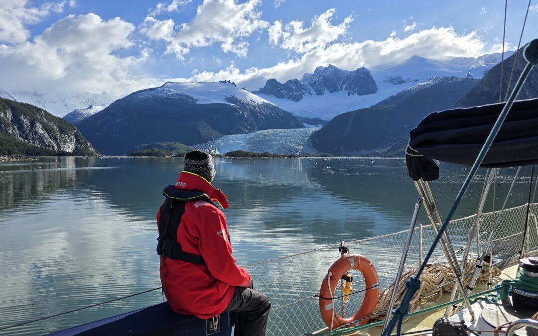
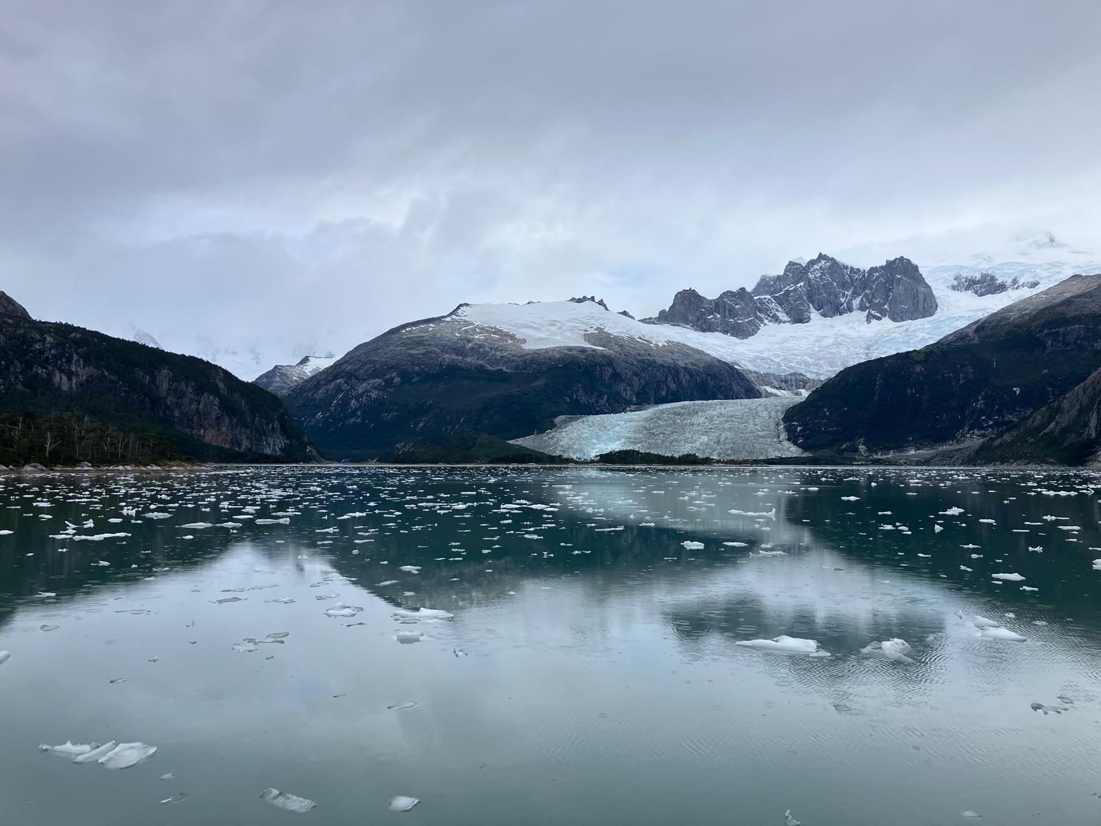
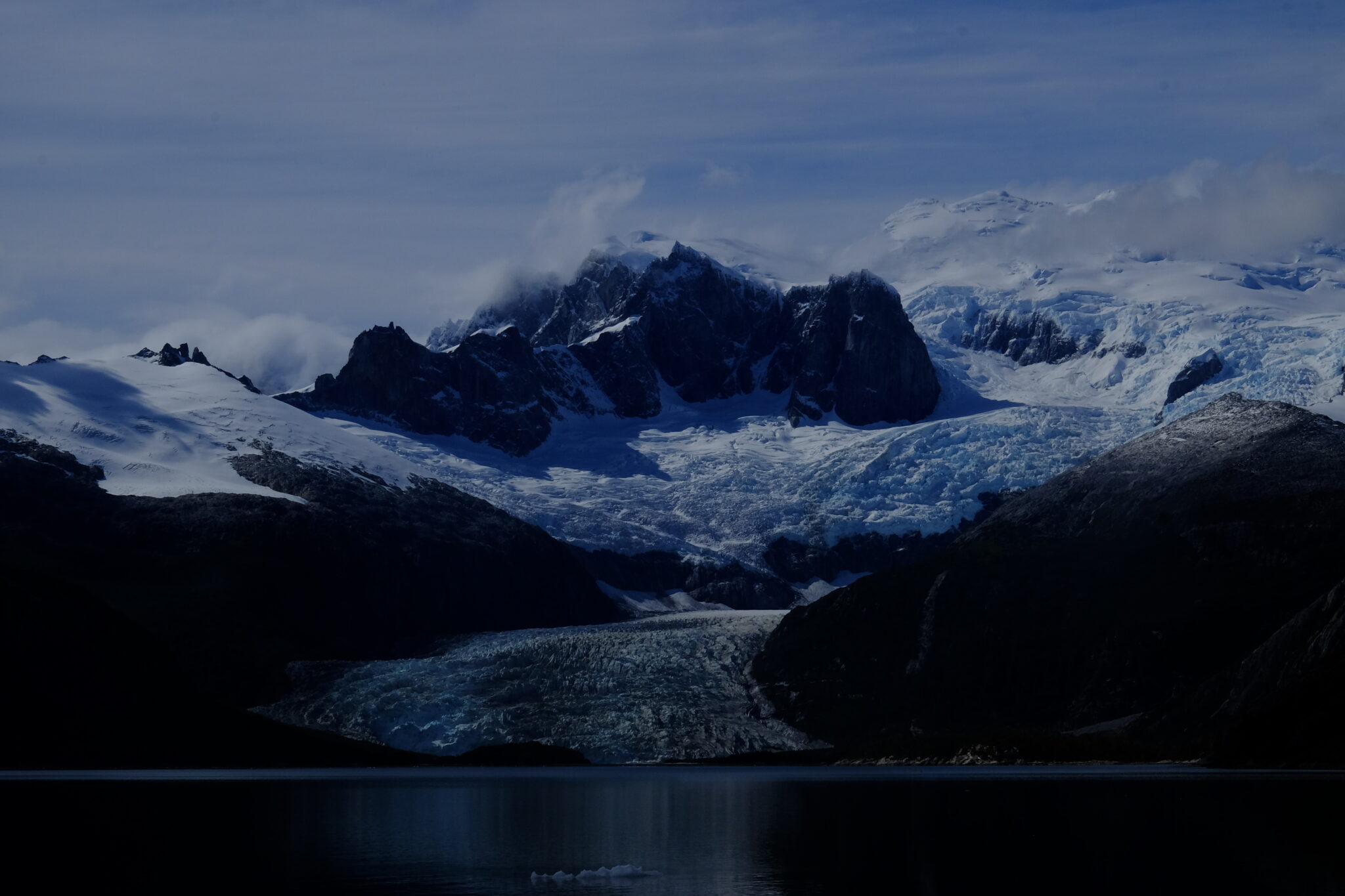
A glacier view in Pia fjord, Darwin cordillera, during a sailing expedition in the patagonian channels (February 2025)
1. Geography and geology
The cordillera extends 170 km west to east and 60 km north to south, between 54°15' and 54°50' south latitude. It is surrounded by water on three sides: the Almirantazgo Canal to the north, the Beagle Channel to the south, the Cockburn Canal to the west. Only its eastern edge, near the Argentine–Chilean border, remains connected to land.
Its highest point is Mount Shipton (2,469 m) — not Mount Darwin (2,438 m), a confusion that persisted for decades following Eric Shipton's 1961 expedition. The ice field covers 2,300 km², equivalent to the combined area of all Alpine glaciers, making it Chile's third-largest freshwater reserve after the Northern and Southern Patagonian Ice Fields.
The massif is built around a high-grade metamorphic complex — kyanite and sillimanite schists formed during the closure of the Rocas Verdes basin in the Cretaceous. These minerals signal extreme pressures and temperatures in the crust, making this the only ensemble of its kind in the southern Andes. The opening of the Drake Passage 45 million years ago subsequently shifted the local tectonic regime to transpressive.
Among the dozens of glaciers in the massif, the Marinelli Glacier is the most studied and most active. It stretches from the cordillera to Ainsworth Bay in the Almirantazgo Fjord. Between 1913 and 2011, its front retreated 15 km — one of the highest retreat rates documented globally for a glacier of this type.
The Darwin Cordillera constitutes a natural laboratory for studying ocean–atmosphere–cryosphere interactions at southern high latitudes. Field data feed directly into global climate models.
Panoramic view of Marinelli Glacier with snow-capped peaks and growlers (Darwin Cordillera, wikipedia)
Extreme climate: the Roaring Fifties
Westerly winds are constant. In the Roaring Fifties, their average annual speed reaches 70 km/h. Williwaws — katabatic gusts tumbling down slopes without warning, a Kawésqar word — can exceed 250 km/h. Annual precipitation exceeds 3,000 mm, mostly as snow at altitude. Visibility collapses in minutes.
FitzRoy called these conditions a "wicked divinity." One hundred and fifty years of failed exploration attempts proved him right.
One of the patagonian glaciers of the Cordillera Darwin during a sailing expedition in the channels (Karukinka Association, Chile, 2025)
Average temperature varies between 0 and 5°C during the cold season (southern winter) and between 5 and 10°C during the warm season (southern summer). These relatively slight thermal variations reflect the moderating influence of the ocean, but mask the constant cooling effect of wind that considerably lowers the perceived temperature.
4. Biodiversity
Fauna. Nutrient-rich fjord waters support humpback and southern right whales. Sea lions, elephant seals and leopard seals frequent the rocky coasts. Over 90 bird species have been recorded, including the Andean condor (wingspan up to 3 m) and, remarkably, the only colony of king penguins (Aptenodytes patagonicus) located outside Antarctica and the subantarctic islands.
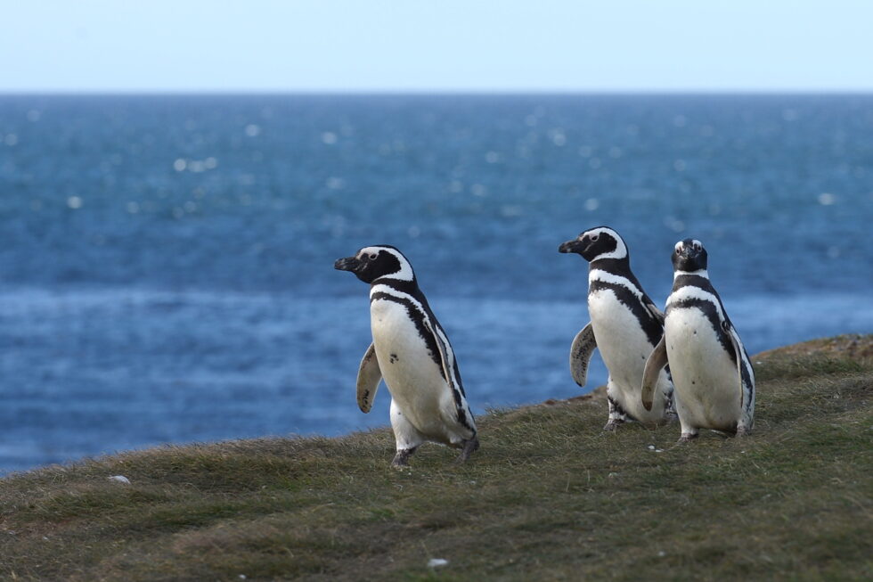
Small group of Magellanic penguins (pingüinos) in insular Patagonia
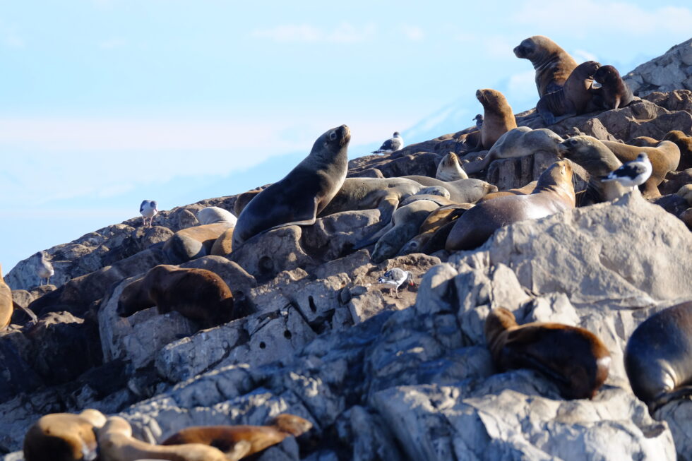
Colony of fur sea lions in the Beagle Channel (Karukinka sailing expedition 2025)
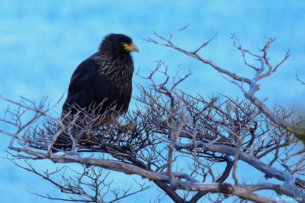
A black Carancho (Reserve of Cape Horn, April 10, 2025, during a sailing expedition at Cape Horn and in the Patagonian channels)
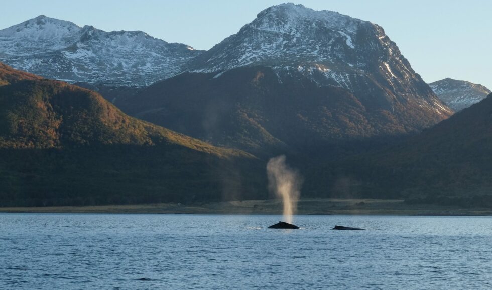
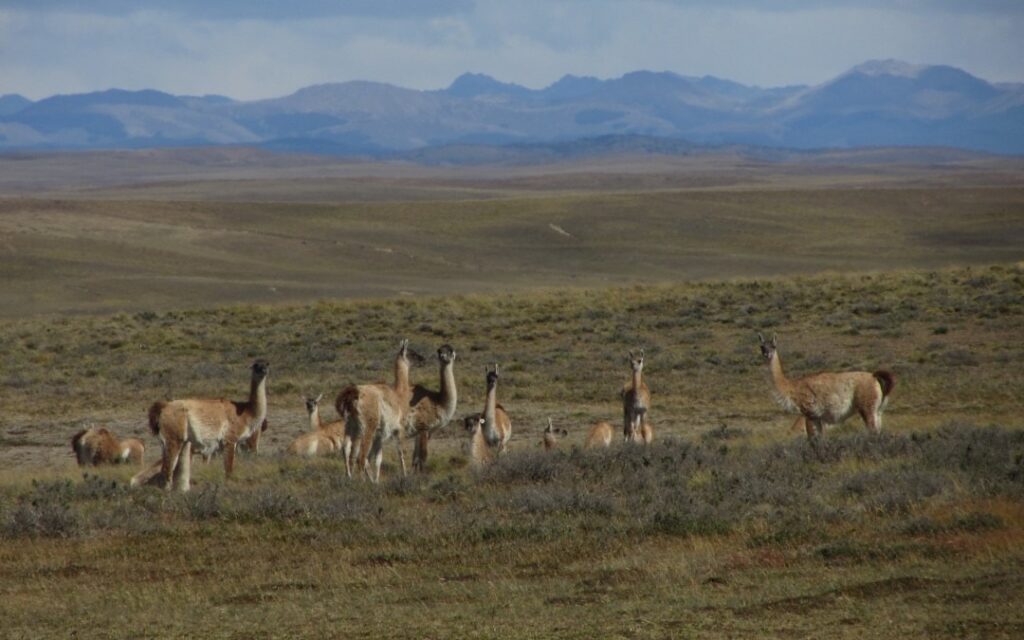
Two southern right whales in the Beagle Channel (2018)Herd of guanacos (Lama guanicoe) during an expedition of the Karukinka association in Tierra del Fuego (2018)
On land, the guanaco (Lama guanicoe) roams the least exposed zones. Canadian beavers, introduced in the 1940s, have colonised tens of thousands of hectares, their dams altering watercourse hydrology and threatening Nothofagus forest integrity.
Beaver dam on Hoste Island (Cape Horn Biosphere Reserve, Chile, autumn-winter expedition 2018)
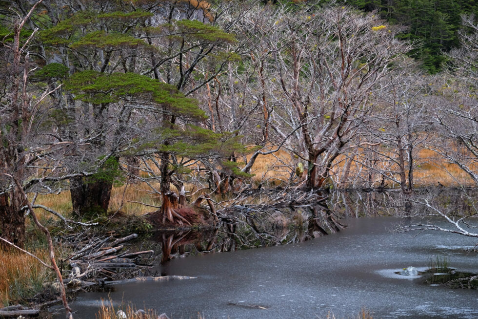
Magellanic forest photographed during a sailing expedition in Patagonia (Beagle Channel, Cape Horn Biosphere Reserve, Chile, 2025)
Vegetation of the Magellanic forest (Cape Horn Biosphere Reserve, 2018)
Vegetation. Lenga (N. pumilio) dominates up to 700 m altitude. Above that threshold, the same species grows as wind-sculpted dwarfs — same genetics, drastically reduced form. Higher still, Magellanic tundra takes over: mosses, lichens, Azorella, Bolax. Beneath the forest canopy, Drosera uniflora (a carnivorous plant) and several endemic orchid species signal the severe nutrient poverty of the soils.
Tundra landscape in the Cape Horn Biosphere Reserve (winter expedition 2018)
A transition zone marks the boundary between the forest tier and the alpine tier, where vegetation consists principally of mosses and lichens capable of resisting desiccating winds and negative temperatures. This Magellanic tundra constitutes a unique ecosystem, harboring highly specialized plant species.
5. First explorers
Father Alberto de Agostini, an Italian Salesian missionary, was the first to seriously penetrate the massif, between 1910 and 1960. His photographs — the first images of the cordillera's interior — and some twenty books on Patagonia constitute a foundational scientific and ethnographic heritage. The national park that protects the massif bears his name.
Alberto de Agostini and his climbing companions, pioneers of mountaineering in the Cordillera Darwin at the beginning of the 20th century.
In 1961, British alpinist Eric Shipton, with Chileans Eduardo García, Francisco Vivanco and Cedomir Marangunic, believed he had made the first ascent of Mount Darwin. The team had in fact climbed a higher summit to the north-west — the future Mount Shipton (2,469 m). The confusion was resolved in 1970 by a New Zealand expedition, whose proposed names were accepted by Chilean geographic authorities.
6. The GMHM first crossing (2011)
On 6 October 2011, six alpinists from the French Military High Mountain Group (GMHM) in Chamonix completed the first integral crossing of the Darwin Cordillera.
The team — Captain Lionel Albrieux (expedition leader), Lieutenant Didier Jourdain, Master Sergeant Sébastien Bohin, Staff Sergeant François Savary, Corporal Sébastien Ratel and civilian climber Dimitri Munoz — set off from the western slope on 6 September, fully self-sufficient, hauling 75 kg of equipment each on pulkas tested in Norway.
In 30 days they covered 150 km as the crow flies (250 actual km), with no reliable map since 1954. On the ridge facing Mount Darwin, a 5 km arête narrowed at times to 40 cm. Winds regularly reached 150 km/h. The team progressed at times on all fours, occasionally lying flat.
The documentary film On Darwin's Edge, made from footage shot by the team, was released on 30 October 2013.
7. Protection and challenges
Alberto de Agostini National Park, created on 22 January 1965 (Supreme Decree No. 80), covers 1,460,000 hectares — Chile's third-largest protected area. In 2005, it was incorporated into the UNESCO Cape Horn Biosphere Reserve, placing the cordillera among the planet's 24 most pristine ecoregions.
Three challenges dominate the conservation agenda: documented glacier retreat (Marinelli: –15 km over one century), the spread of Canadian beavers, and growing cruise ecotourism pressure toward the glaciers — which requires careful management, particularly around fragile, unenclosed Yagan archaeological sites on the coastline.
One of the many fjords of Alberto de Agostini National Park (sailing expedition, Patagonian Channels, Chile, 2025)
Cape Horn (Cabo de Hornos in Spanish, Kaap Hoorn in Dutch, Loköshpi in the Yaghan language) is far more than just a geographic point. Located at 55°58′ south latitude and 67°16′ west longitude, this rocky promontory at 425 meters above sea level marks the southernmost point of the Tierra del Fuego archipelago and symbolically marks the meeting of the Atlantic and Pacific Oceans. At 965 kilometers from the Antarctic continent and just 138 kilometers from Ushuaia, Cape Horn rises as the ultimate sentinel of the Americas before the vastness of the Southern Ocean.
Table des matières
Geographical Position of Cape Horn
Location within the Fuegian archipelago
Cape Horn is situated on Horn Island (Isla Hornos), the southernmost island of the Hermite archipelago, itself part of the vast island complex of Tierra del Fuego. This modestly sized island (approximately 6 km by 2 km) is administratively part of the commune of Cabo de Hornos, in the Antarctic Province, within the Magallanes and Chilean Antarctic Region.
Contrary to popular belief, Cape Horn is not the southernmost point of the South American continent — that title belongs to the Diego Ramírez Islands, located 105 kilometers to the west-southwest. However, Cape Horn remains the southernmost of the great historical sailing capes and the most symbolic nautical waypoint in the Southern Hemisphere.
Precise Coordinates and Strategic Distances
With exact coordinates of 55°58′28″ south latitude and 67°16′10″ west longitude, Cape Horn lies at a unique geographical intersection where the major oceans of the Southern Hemisphere converge:
Distance from Ushuaia (Argentina): 138 km to the north-northwest
Distance from Puerto Williams (Chile): 56 km to the north
Distance from the Antarctic continent: 965 km to the south
Distance from the geographic South Pole: 2,535 km
Geographic map showing Cape Horn at the southern tip of South America, adjacent waters including Drake Passage, and nearby islands located in the Pacific, Atlantic, and Southern Oceans. (Source : Wikipedia)
Geological Formation and Geomorphology
Regional geological context
The Cape Horn region is embedded in the complex geological history of Tierra del Fuego, shaped by Andean orogeny and Quaternary glaciations. The archipelago was formed through a process of collapse and fragmentation of the southern tip of the Andes, amplified by glacial erosion and rising sea levels following the last Ice Age.
The geological formations of Horn Island consist mainly of sedimentary and volcanic strata from the Upper Cretaceous period, bearing witness to the intense tectonic activity related to the closure of the Rocas Verdes marginal basin and the early stages of Andean compression. This explains the rugged topography of the region, characterized by moderate elevations but extremely fragmented coastlines.
Coastal Morphology
To sailors, Cape Horn appears as a 425-meter cliff dropping directly into the ocean. This distinctive coastal morphology is the result of marine erosion, Quaternary glacial-interglacial cycles, and ongoing tectonic activity.
The Magellan-Fagnano Fault, a left-lateral strike-slip fault running east–west through Tierra del Fuego, indirectly influences the geomorphology of the Cape Horn region. With a movement rate of approximately 6.4 mm/year, this fault is a reminder of the continuous tectonic activity that shapes this part of the world.
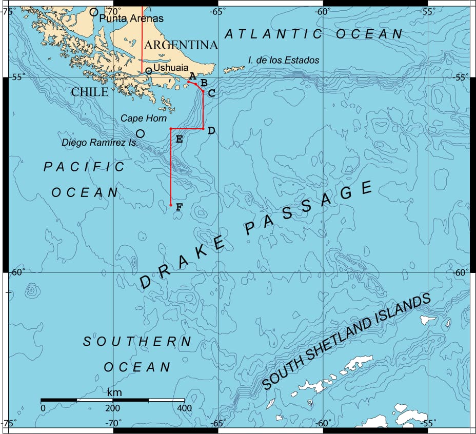
Cape Horn marks the northern boundary of the Drake Passage, an 809-kilometer-wide strait separating South America from the Antarctic Peninsula. This strait represents the shortest distance between Antarctica and any other continental landmass, only 135 kilometers wide at its narrowest point, between Cape Horn and Snow Island in the South Shetlands.
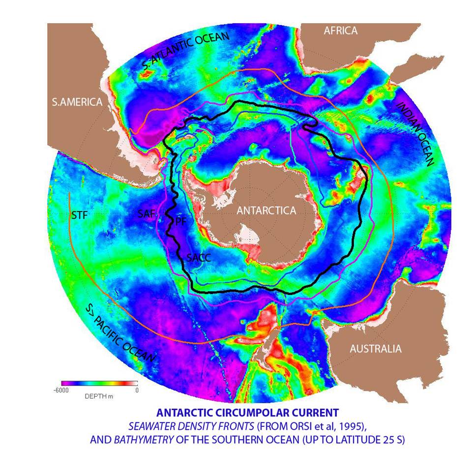
Map of the Antarctic Circumpolar Current and Seawater Density Fronts Around Antarctica, Showing Ocean Depth and Main Fronts Near the Southern Ocean and Surrounding Continents (source : Wikipedia)
Antarctic Circumpolar Current
The Drake Passage is the point of maximum constriction of the Antarctic Circumpolar Current (ACC) — the most powerful ocean current on Earth. The ACC transports an average of 150 million cubic meters of water per second — nearly 100 times the combined flow of all the world’s rivers. Its strength peaks at Cape Horn.
This oceanographic phenomenon is the main driver of the extreme weather conditions in the region. With no continental barriers, the ACC fuels the relentless west winds known as the “Roaring Forties” and “Furious Fifties”.
Subpolar Oceanic Climate
Cape Horn enjoys a subpolar oceanic climate, with relatively stable yet cold year-round temperatures. Average temperatures hover around 5°C, and the area receives up to 2,000 mm of rainfall annually, with nearly 278 days of rain per year.
Wind is the dominant climatic factor, averaging 30 km/h but frequently exceeding 100 km/h during storms. These conditions are directly linked to Cape Horn’s position within the zone of the Furious Fifties — a corridor of uninterrupted westerly winds that circle the Southern Hemisphere.
Biodiversity and Conservation Status
Cape Horn Biosphere Reserve (UNESCO)
Since 2005, Cape Horn has been part of the Cabo de Hornos Biosphere Reserve, recognized by UNESCO under the Man and the Biosphere Programme (MAB). The reserve spans 4,884,273 hectares, encompassing a core area of 1,347,417 hectares composed of the Alberto de Agostini National Park and Cape Horn National Park.
The southernmost part of Horn island during a sailing expedition to cape Horn with SY Milagro (Association Karukinka, 2025)
Cabo de Hornos National Park
The Cabo de Hornos National Park, created on April 26, 1945, spans 63,093 hectares and includes the Wollaston and Hermite archipelagos. It is the southernmost protected area on the planet, hosting unique subantarctic ecosystems adapted to harsh climatic conditions.
Exceptional Biodiversity
The Cape Horn region is home to the southernmost forest ecosystem in the world and harbors 5% of the planet’s bryophyte species (mosses and liverworts).
The flora comprises Magellanic subpolar forests, dominated by Nothofagus species (southern beeches), alongside rich communities of mosses, lichens, and ferns adapted to extreme cold and humidity.
Primary forest in Tekenika Bay (Cape Horn Biosphere Reserve, Karukinka Expedition, 2018)
The marine fauna is equally impressive: humpback whales, southern dolphins, South American sea lions, elephant seals, and orcas are frequently observed. The birdlife is dominated by black-browed albatrosses, giant petrels, Magellanic penguins, imperial cormorants, and even Andean condors.
Whales observed during a sailing expedition through the Patagonian channels (Chile) autumn 2018 (c) Karukinka
Maritime History and European Discovery
The Discovery of 1616
Cape Horn was discovered on January 29, 1616, during a Dutch expedition led by Willem Schouten and Jacob Le Maire. They sought an alternative to the Strait of Magellan to bypass the trade monopoly of the Dutch East India Company.
The cape was named in honor of the Dutch town of Hoorn, the expedition’s port of origin. This discovery profoundly altered maritime trade routes by offering a new corridor — broader than the Strait of Magellan, but vastly more dangerous.
A Historic Trade Route
For nearly three centuries, Cape Horn was a crucial maritime passage for global trade routes. Large sailing ships — known as “Cape Horners” — traversed these waters carrying goods between Europe, the Americas, and Asia: including nitrate, grain, wool, and gold from Australia.
The era of the great sailing ships ended with the opening of the Panama Canal in 1914. The last commercial sailing vessel to round the Horn was the Pamir, in 1949, marking the close of a legendary chapter in maritime history.
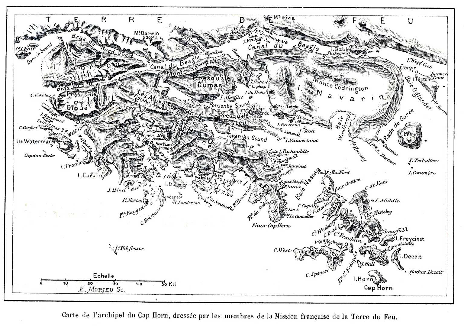
One of the many maps produced during the French Cape Horn Mission (1882–1883) led by Commander Martial
Indigenous Context and Cultural Memory
The First Inhabitants
Before European colonization (1860–1920), the Cape Horn region was solely inhabited by the Yaghan people (also Yámana) — marine nomads who navigated these waterways in bark canoes. These hunter-gatherers developed an extraordinary maritime culture adapted to the severe subantarctic climate.
The Cape Horn promontory was called Loköshpi in the Yaghan language, reflecting a rich indigenous toponymy. According to research by Karukinka Association, over 3,000 indigenous place names (in Yaghan, Haush, and Selk’nam) have been recorded in the area, revealing a detailed and sensitive knowledge of the landscape.
Preservation and Memory Work
For over a decade, the Karukinka Association, founded by Lauriane Lemasson in 2014, has worked to archive, preserve, and honor the memory of the indigenous cultures of the Cape Horn region. Their expeditions in the Patagonian channels, from Tierra del Fuego to Cape Horn, have contributed to sound archives, toponymic mapping, and cultural education.
This work is all the more crucial when one considers that these peoples experienced cultural genocide in the early 20th century, their population declining from over 10,000 individuals to fewer than 500 by 1920.
Contemporary Challenges and Futures
Tourism and Conservation
Cape Horn now attracts a growing number of expedition cruises, mostly departing from Ushuaia or Punta Arenas. While weather constraints limit visitor numbers, increased traffic poses conservation challenges for fragile ecosystems.
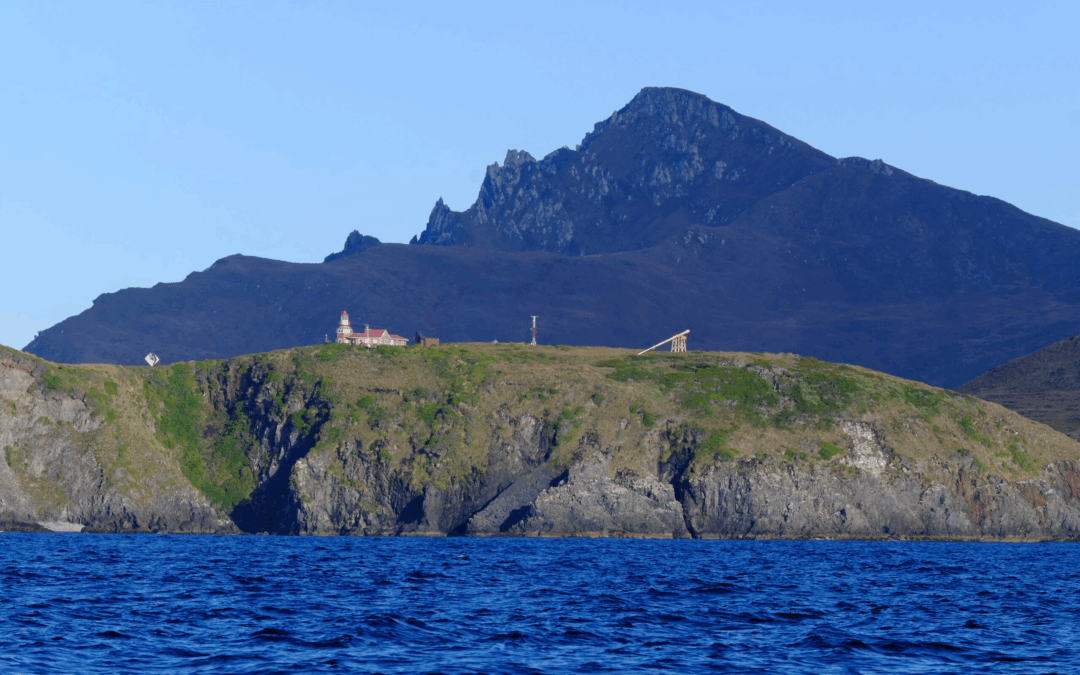
Chile maintains a military base on Horn Island, with a garrison, a chapel, and a lighthouse. The lighthouse keeper and their family constitute the only permanent inhabitants of this isolated place.
The Cape Horn lighthouse with the Cape promontory in the background during the rounding of Cape Horn by sailboat in April 2025 (Karukinka Expedition, sailing vessel Milagro)
Scientific Research
Cape Horn continues to be a site of important scientific research, particularly regarding climate change, oceanography, and subantarctic biodiversity. The work of the Karukinka Association and its partners contributes to the growing body of knowledge on extreme ecosystems undergoing rapid transformation.
Conclusion
Cape Horn occupies a unique place on the globe — both physically and symbolically. Situated at the southern tip of Horn Island in the Hermite archipelago, at 55°58′ South and 67°16′ West, it marks the symbolic point of convergence between the Atlantic and Pacific Oceans, between the Americas and Antarctica.
Its geographic position explains its extreme oceanographic and climatic conditions, forged over millennia of tectonic, glacial, and atmospheric dynamics. The Antarctic Circumpolar Current, the furious westerly winds, and the legendary nature of the Drake Passage make this one of the most dangerous maritime zones in the world.
Yet beyond the physical landscape lies a story of human history, resilience, tragedy, and conservation — from the Yaghan navigators to the Dutch explorers, from the age of sail to the fight to protect its fragile ecosystems.
To understand Cape Horn is to grasp the essence of a place where extremity meets universality, and where the end of the world becomes a mirror of the planet’s past, present, and future.
If you plan to go stop at La Rochelle this summer, don’t miss this trip to the end of the world! This sound and immersive fiction was created by Sébastien Laurier in collaboration with the Phare du bout du monde (Lighthouse of the end of the world) association and the town of La Rochelle: for one hour, you are transported into the far south of Patagonia, from the post-office of the tip of the Minimes harbour.
Several members of the Karukinka association took part in this project, among whom Mirtha Salamanca (Selk’nam woman, member of the Argentinian indigenous participative board), voiced in French by Marie-Pierre Lemasson, cash-flow manager of the association, who’s known by Mirtha since 2019 when she first came to France under the project Haizebegi. Indeed, our main protagonist, Lauriane, finds echo in Karukinka’s founder…
And if you wish to go further, come with us to visit the “real” lighthouse of the end of the world next winter and spring (North Spring!) (February-April 2025) onboard the association’s sailing ship: the Milagro. More information on: https://karukinka-exploration.com/patagonie-2025/
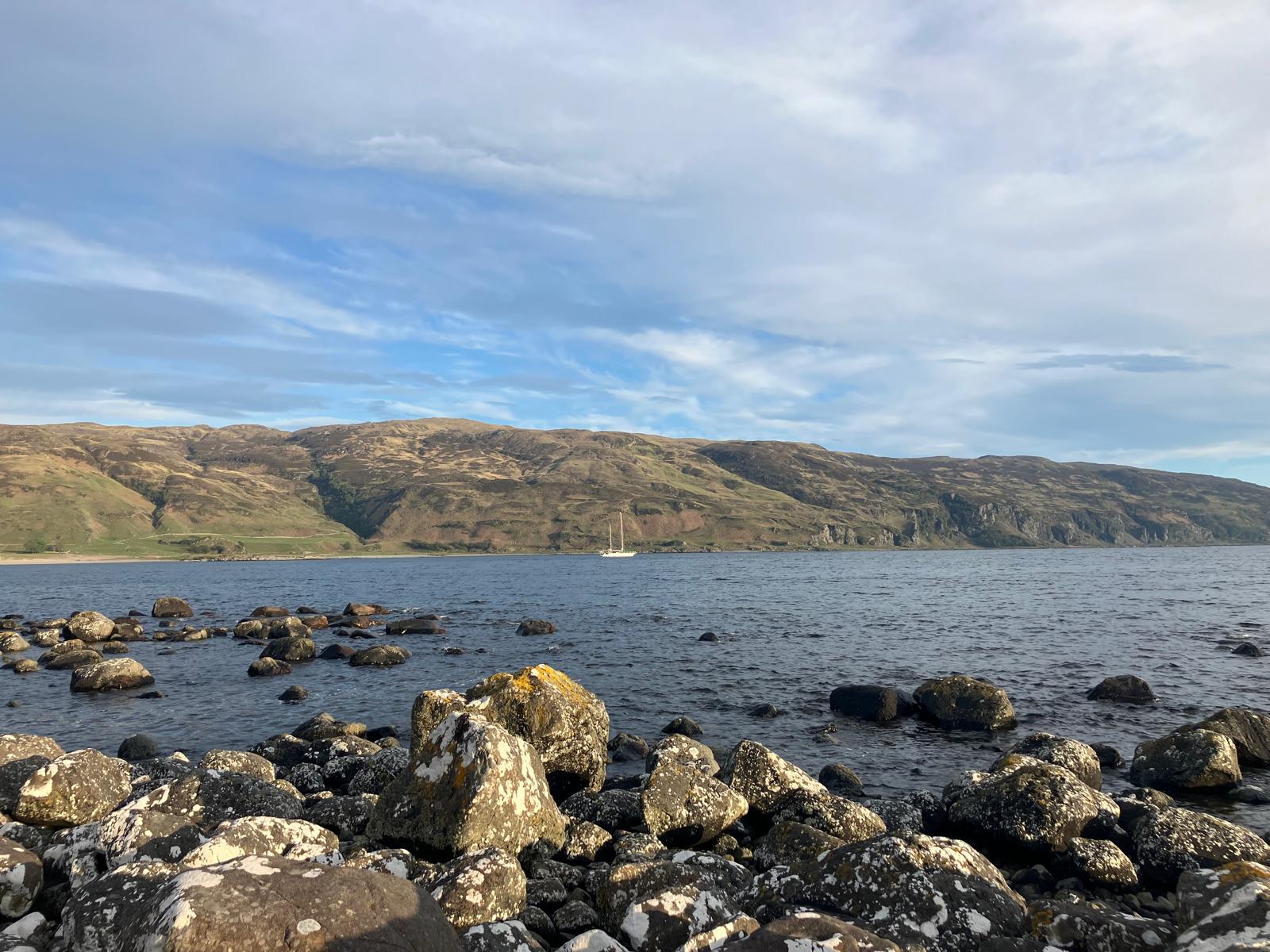
Early in the morning, we raise anchor at the still and at a few cable lengths from Castle Moy on Loch Buie (Isle of Mull). In this loch facing south-west, last night was moderately pleasant, due to a small swell from the south that came before the wind forecast in the same direction, forcing the Milagro to keep an annoying stand through this swell (and cradle us of course, but we would have gladly done without it!).
By accumulating starting the engine, lifting the anchor, cleaning the pile of gravel and sludge that stained the chain and anchor, and hoisting sails to be able to navigate only through them, we have set a new record of a minimum use of the engine: 20 minutes! We are able to leave the loch thanks to the mizzen mast and the yankee, at close, at 5.5 knots: what’s the use of pushing it?
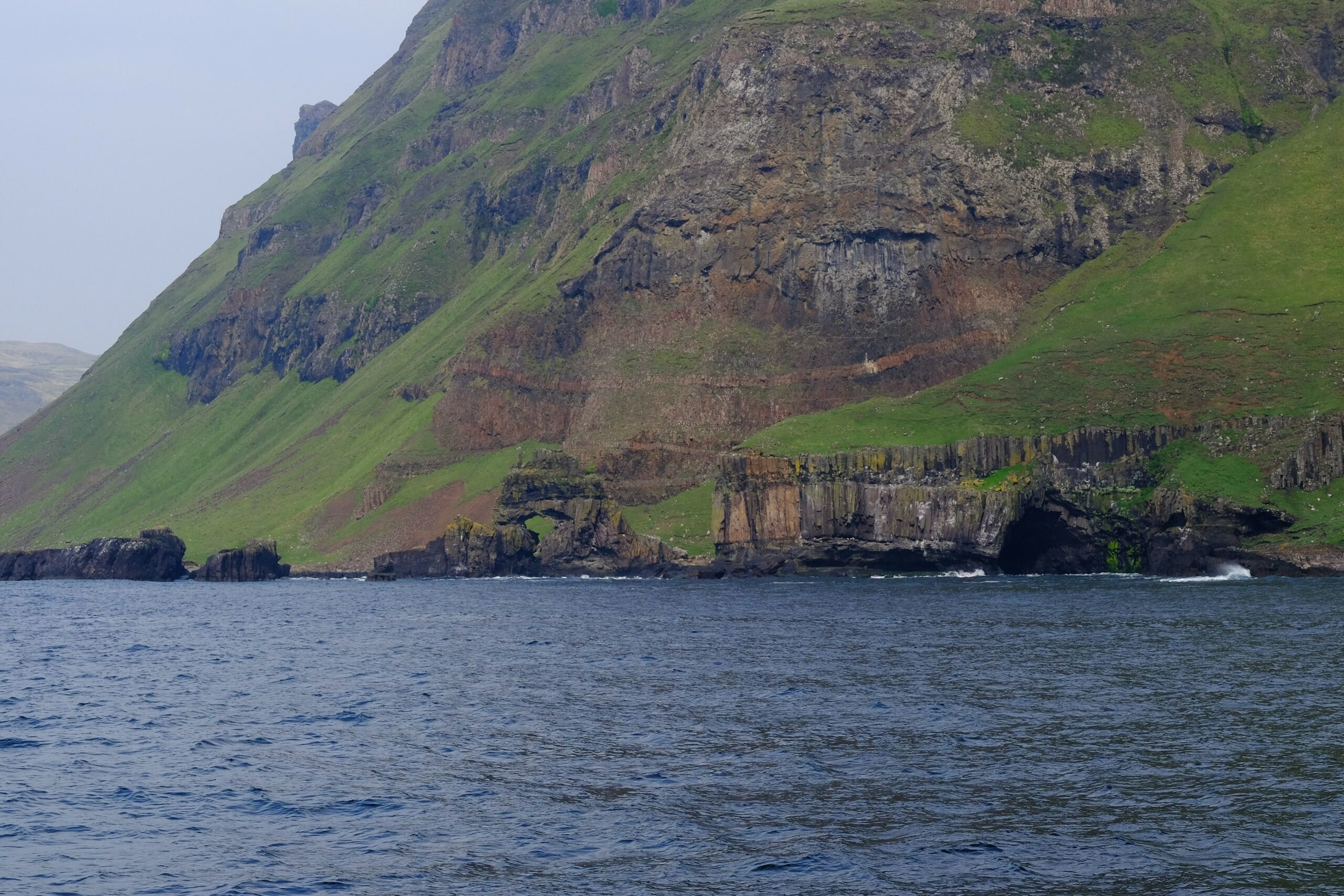
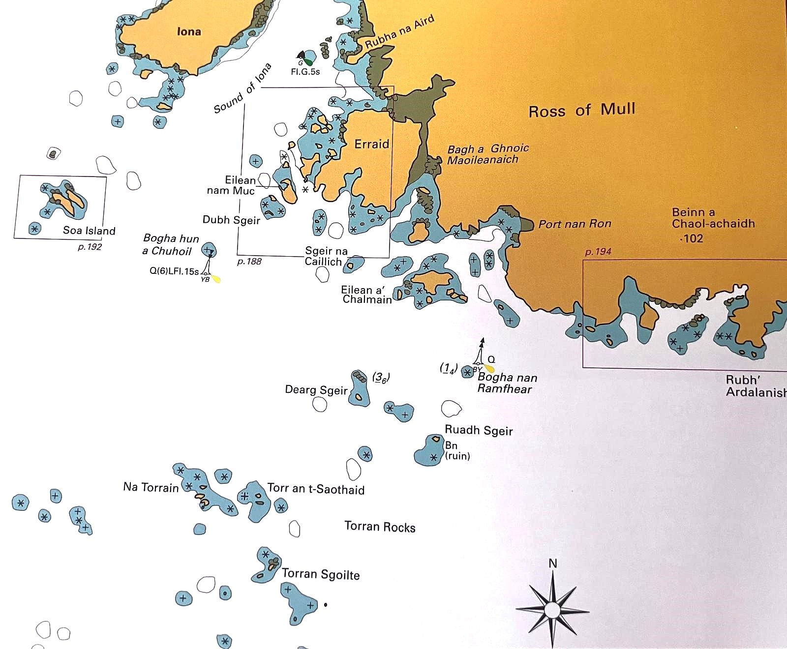
The forecast is good (South 3 to 5 going to 2 to 4 for a few hours, before going to 3 to 5 and move to North-West 4 to 6 south of the Isle of Mull. We make the most of the ebbing tide to keep at good distance from the southern coast, despite a closed haul. This part of the island situated between Loch Scridain (North) and the end of Firth of Lorn (South) form a peninsula called Ross of Mull. The further West we navigate, the more complex the bottoms get, with many reefs to go through to reach our goal: Iona.
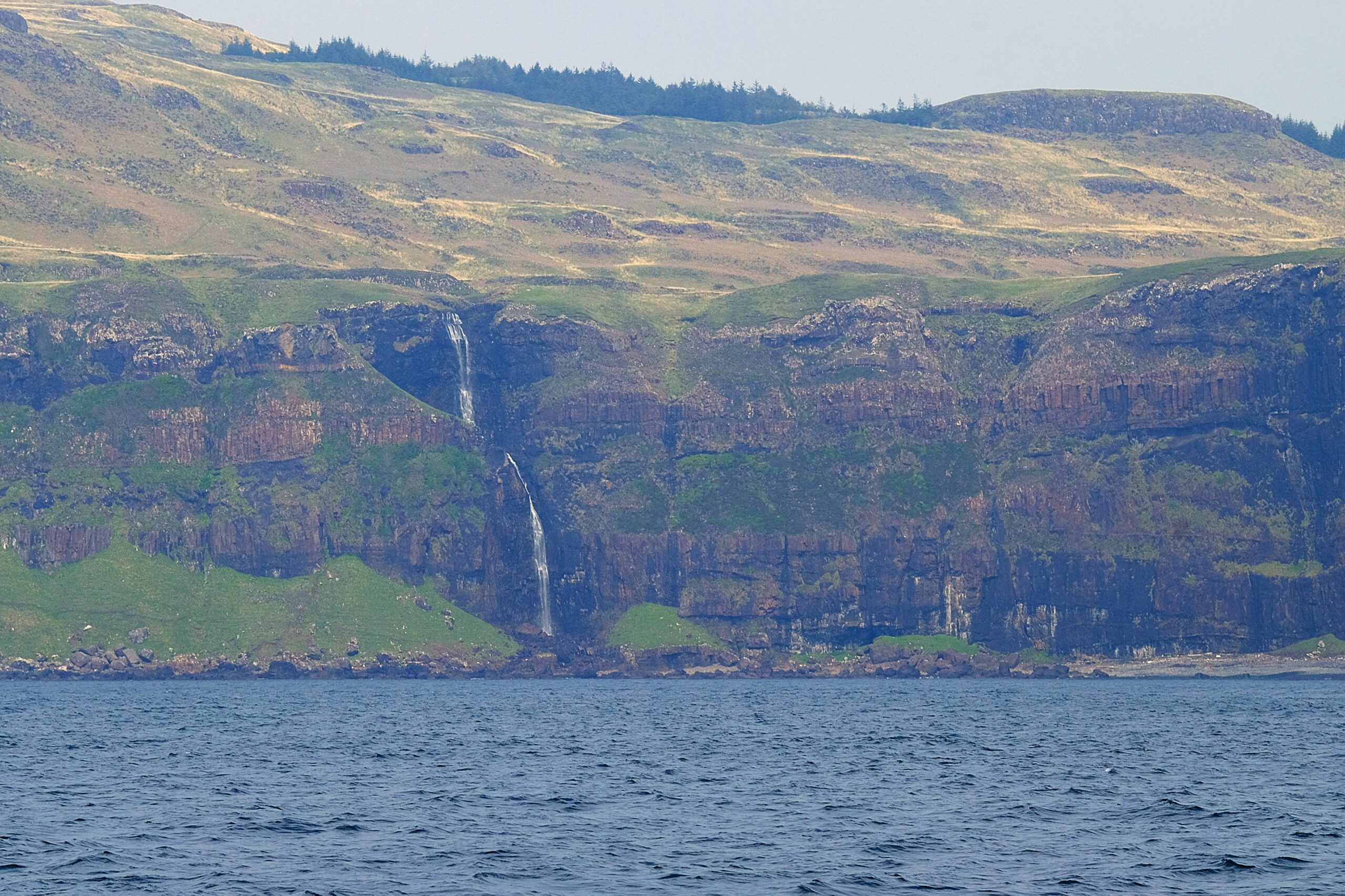
The basalt cliffs (palisades again!) are, at times, shaped into caves and arches sculpted by erosion and are interspersed by gorgeous turquoise waterfalls and creeks. Disregarding the water temperature (14 degrees), this colour could entice us to go swimming! We are stunned by the beauty of the landscape and change course to come closer, close-hauled to Malcom’s Point waterfall, before going back to our southern course.
Gradually, we come across more demanding passages, of which the Torran Rocks mapped by Bogha nan Ramfhear cardinal and the entry towards the south of the Sound of Iona. Once again, we experience many moments of solitude (and laughter obviously) which intersperse with the times when we name the rocks, bays, reefs, islands and capes! Our encounters with locals who didn’t speak Gaelic reassured us when we talked about it with them: they were only just about able to mumble a few words! If you want to get an idea of the moment, just look at the map of that area!
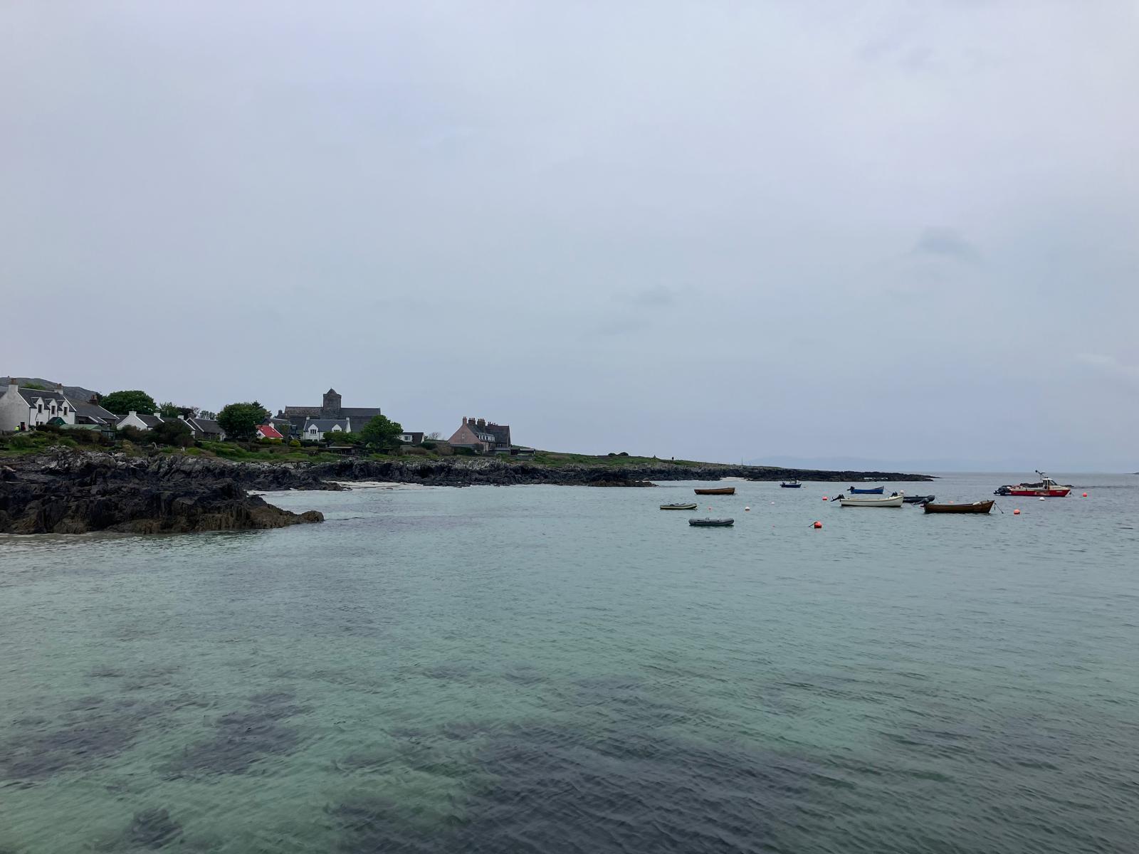
We enter the channel separating Ross of Mull from Iona by sail (close-hauled, 5.5 knots). Being the only sailing ship in this channel at the end of the afternoon, we decide not to set course north by means of the engine.
We prefer to take our time to study the map thoroughly and look for any visual signs onshore to successfully cross the channel by exclusively relying on the alignments (cathedral, Bull Hole…) and the sounder indicators, rather than following what’s on the screens. We prepare several recordings by means of the compass and jibing manoeuvres in relatively narrow passages to go round sounders of a sand and rock band between 10cms and 1m60, then sail starboard off Eilean nam Ban Island and its amazing colours. We arrive in a new area and reach anchorage of Port na Fraing and its white sand beach, just for ourselves and on 7m bottom! (those of Martyrs’ Bay or Bull Hole are more crowdy). The forecast 4 to 6 Beaufort arrive at the end of the day, yet we are safe in the channel, under Iona’s wind.
After a restful night, we leave on the boat towards Martyr’s Bay’s ferry dock to visit this sacred place of the Scottish history of which Vicky Gunn has told us about: she is medieval history research we had met in Loch Melfort.
Iona is a small island facing the Atlantic Ocean and has only one land at the surface towards the West at this latitude, given the dangerous surroundings of Skerryvore (next comes Canada). It’s surrounded with reefs of which the black rocks are set in contrast with the white sand beaches. Bestowed with a small village offering all the essential services (including a primary school) and several craftworkers (potters, wood sculptors, jewellery designers, basket makers, weavers…), Iona is considered one of the main spiritual places of Scotland. Many come in pilgrimage and/or to find peace during spiritual retreats.
Why is this small island so important, then? This is what we’ll share with you further in details thanks to the information given by Vicky during our visit, and through the reading and research that followed.
The first conclusion we can make is that the cultural and historical importance of Iona is totally out of proportion, given its size. It has been inhabited at least since the Bronze Age as can be seen with Blàr Buidhe site; but it is only from the 6th century that the importance of Iona was documented. Several toponyms are associated with the island, including “Ì”, “Ì Challuim Chille” (Iona of St Columba to avoid any confusions), “Eilean Idhe” (The isle of Iona) and “Ì nam ban bòidheach” (Iona of the beautiful woman in gaelic), and its inhabitants are called the Idheach.
563 saw the arrival of twelves disciples sailing on Columbia from the north of Ireland. They founded the second Christianisation mission of Scotland, one century and a half after the former one led by Ninian of the Isle of Whithorn in 397, and of which the precepts would have been conveyed all the way to the Shetland islands. It was a strategic move to establish a church and a monastery on Iona, since that island was situated on a waterway allowing passage from Inverness to Ireland but also the whole Celtic world. Like Holy Island and Portmahomack, Iona quickly became a source of dissemination of the Celtic version of the Christian religion and of new ideas and creations (including illumination/calligraphy, music, painting and art crafts). Choosing this place to do it was very efficient because it was situated on a main cultural and commercial axis at the time. The small community that had settled there also developed a subsistence economy with an important farming activity (cereal cultures and breeding), fishing and building. They were not completely self-reliant, since they used to import wine, pigments and oils from the south of France for liturgic purposes!
For 34 years, Columba developed close ties with royalty, converting, for example, King Bruce and the Picts to Christianism, following a spiritual battle he won against the referent of their kingdom. Columba also facilitated, until his death in 597, the establishment of an independent realm in west Scotland: Argyll. Most of this information reached us thanks to Adomnàn, a diplomat who succeeded to and was St Columba’s biographer, by leading the mission for 25 years, in the 7th century. He wrote several major works to understand that period, including “The life of Saint Columba” (“Vita Sancti Columbae”, circa 690) and “The Law of the innocents” (“Lex Innocentium” dated 697).
In the 8th and 9th centuries, the Vikings attacked Iona on several occasions, attracted by the treasures of the monastery. 825 saw one of the worst Viking raids: Father Blathmac and the monks with him were tortured for the purpose of getting them to reveal the place where the relics of St Columba were hidden, a poem mentioning they would lay inside a chest covered with gold and silver. When nothing was confessed, they were slaughtered in a bay later called Martyrs’ Bay. The fear of those raids and their repetitive nature was such that it had led to an exodus of many clergymen who made sure to take the rarest relics with them (including St Columba’s bones) and another treasure: the Book of Kells (created in Iona 200 years after St Columba’s death, this book is considered one of the most remarkable religious works of the time and can now be seen at Trinity College in Dublin). Despite these relentless attacks, the monastery remained active, and the frequency of the raids only decreased in the 10th century when the Vikings settled in the Hebrides converted to Christianism and adopted St Columba as their saint patron. Several engraved tomb stones preserved in the museum show the Viking influence with inscriptions in rune.
In the 11th century, Iona and most of the western Scottish isles were under the power of the king of Norway. The distance made it quite complicated to rule the region, the king entrusted a Norwegian-Gaelic warrior with the task: Somerled. He became the first Lord of the Isles, controlling a region spreading from Kintyre to the Inner Hebrides. His descendants were the MacDougalls of Lorn, MacDonalds of Islay and MacRuairis of Garmoran, several of them having played a major role in the 14th political manoeuvres and independence wars.
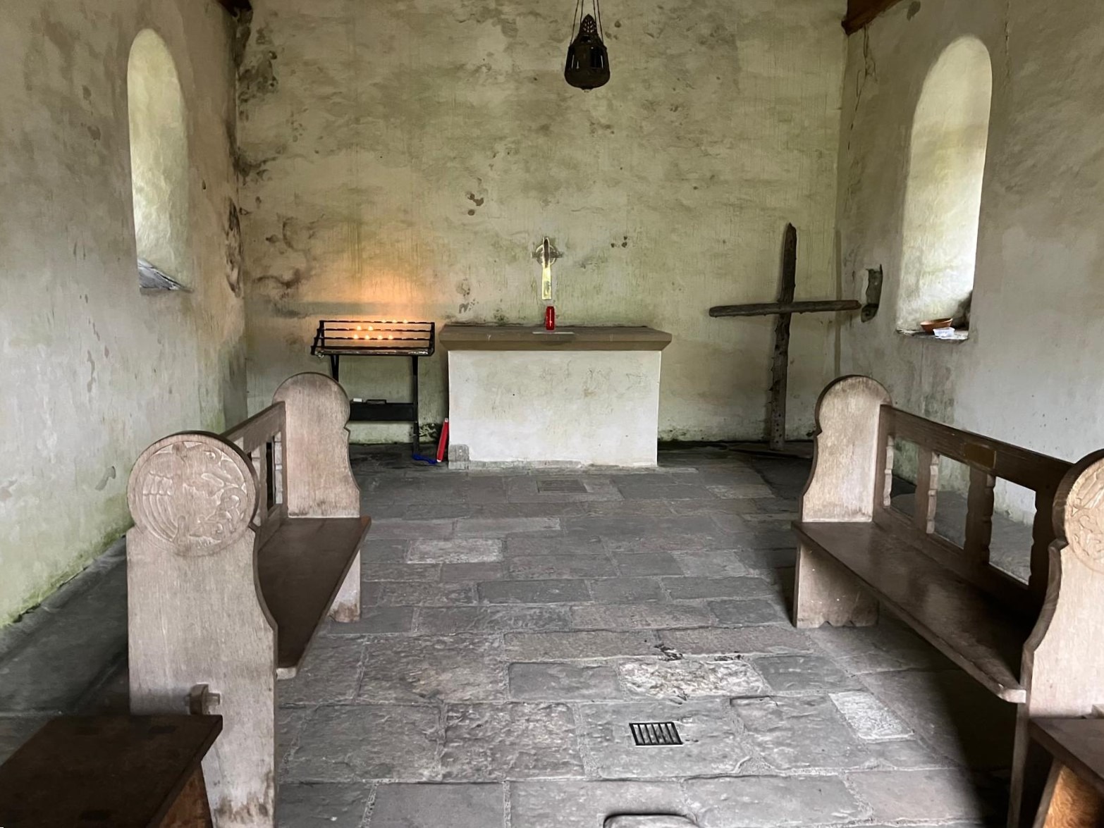
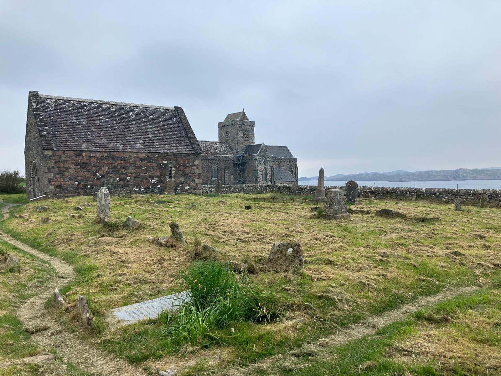
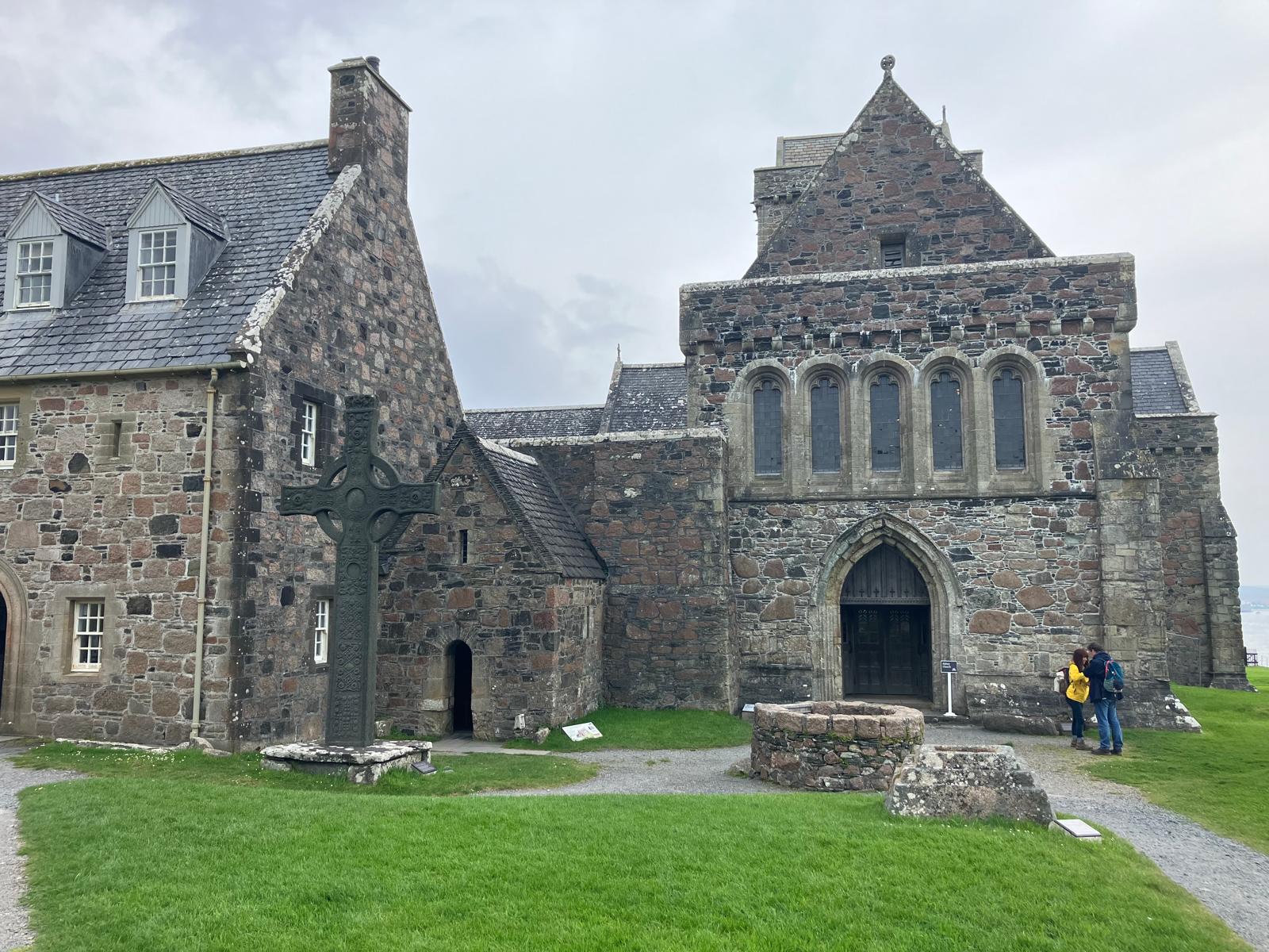
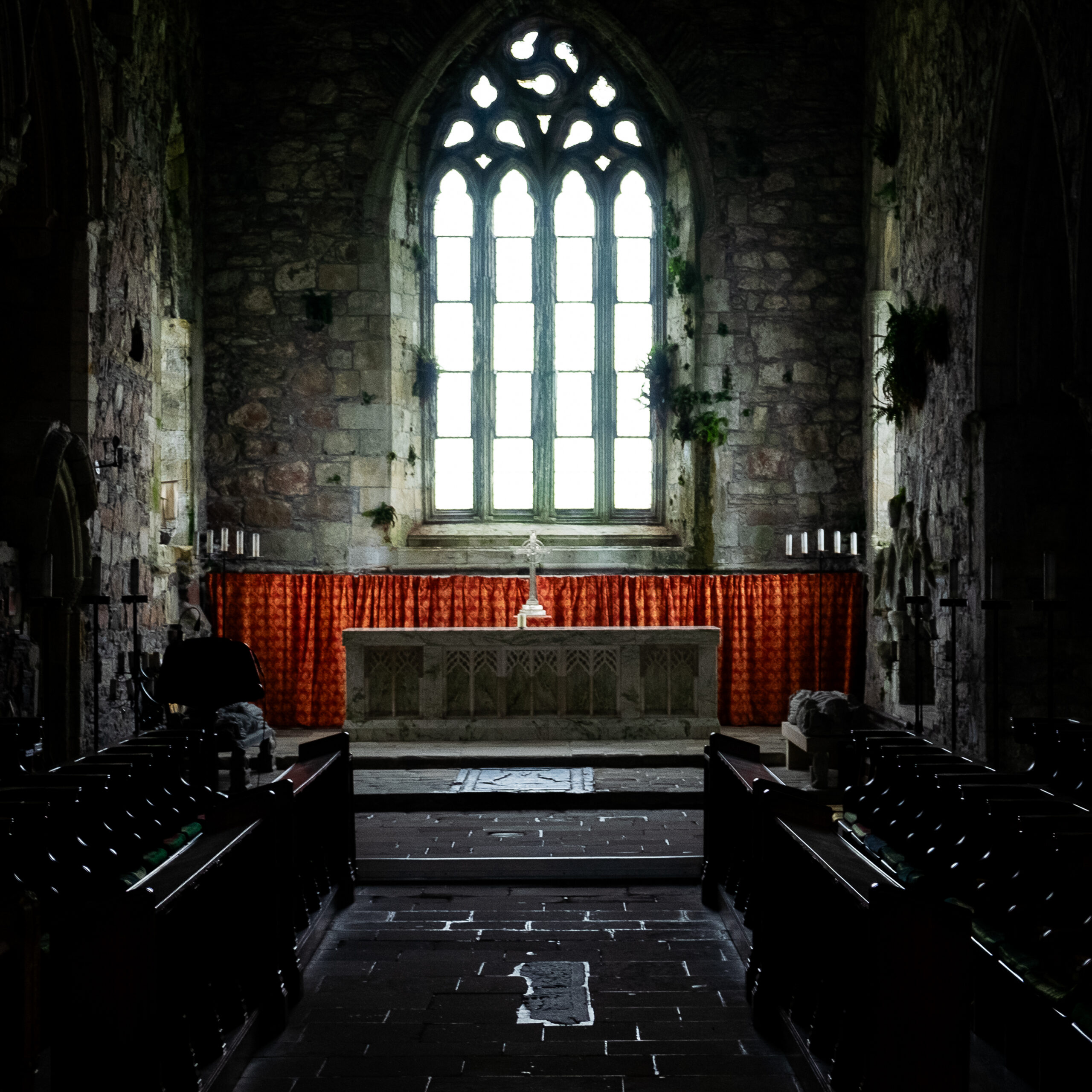
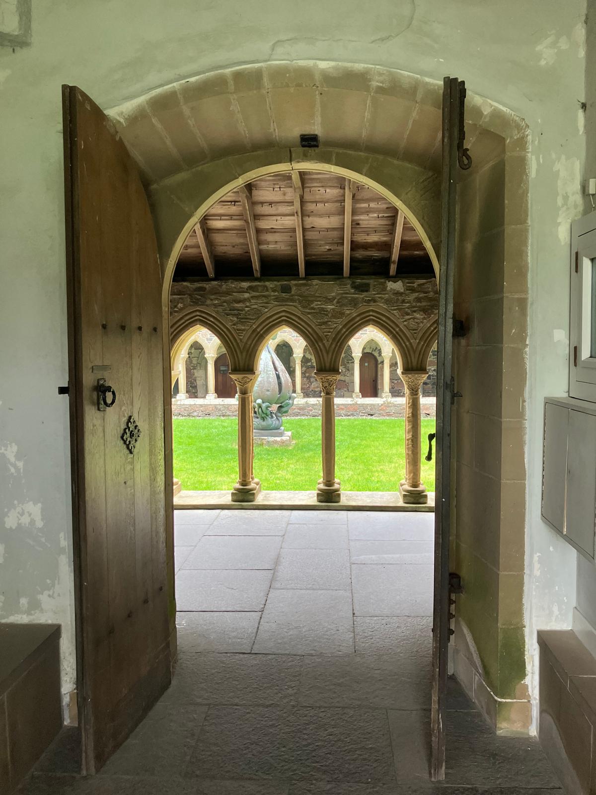
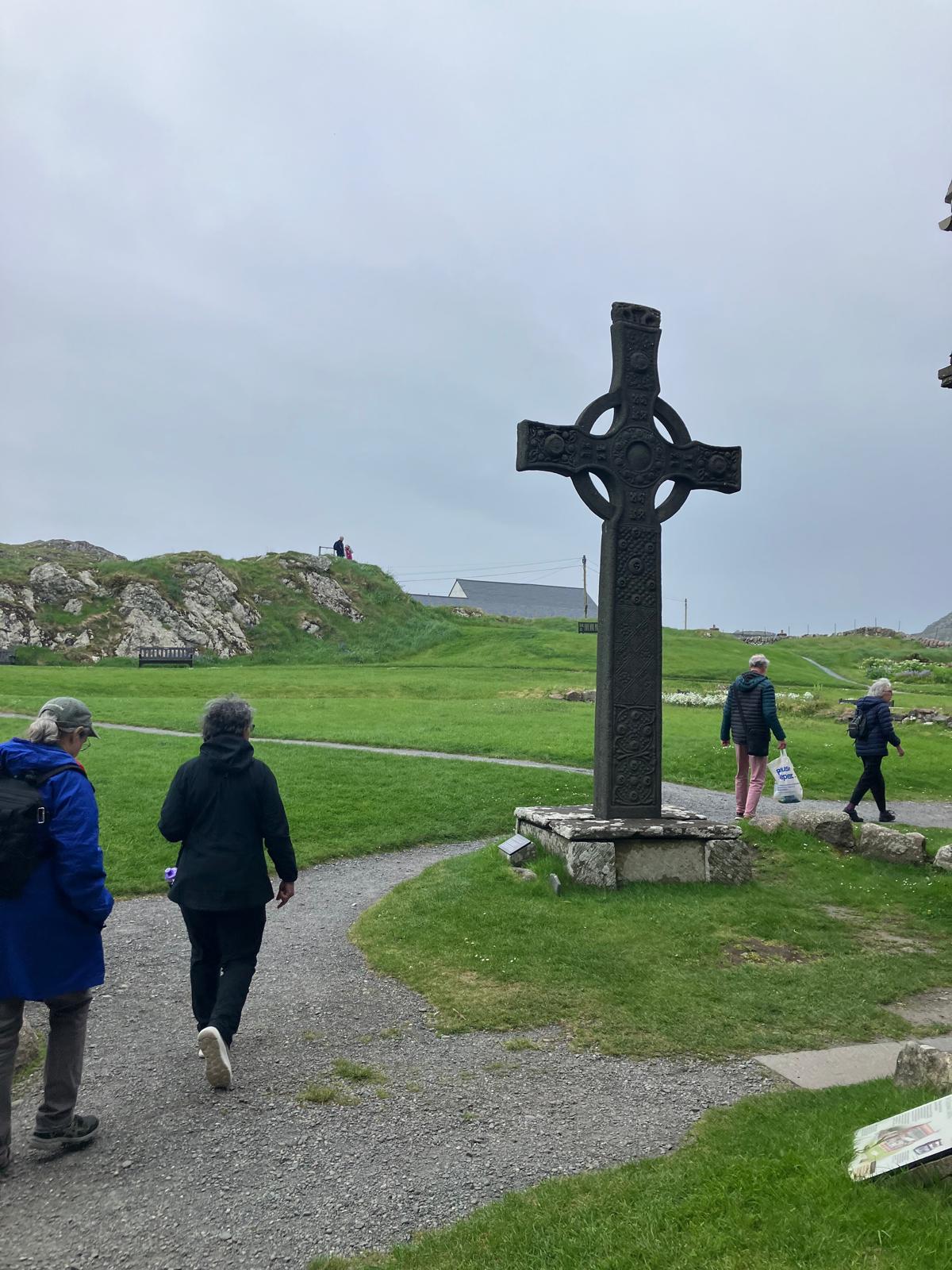
During our excursion onshore and on our way to the abbey, we walked across the ruins of a convent and followed the Road of the Dead (“Sràid nam marbh”), a road paved with pink granite and connecting the Martyr Bay with St Columba’s tombstone situated at the centre of the benedictine abbey built in the 15th century. This route was the very same one followed by pilgrims and during the processions dedicated to the graves of important actors of the Gaelic world in the cemetery of Reilig Odhrain surrounding St Oran chapel which was built in the 12th century (the oldest intact structure of the island). It is said that, in this cemetery, would lay 48 Scottish Kings (among whom Macbeth / Mac Bethad), members of the clan of MacDonald Lord of the Isles, some of whom with Norse ascendents (MacKinnons, MacLeans and MacLeods) and, in a small chapel so simple it is baffling, the bodies of the most important lord and war chiefs of the western Scottish islands. Many old, sculpted tombstones are still in this cemetery, while others have been moved to the museum of the abbey cloister to ensure their preservation. It is said that the first crosses on the tombstones, considered rather conventional nowadays, would have appeared in Iona approximately in 600, as shown with the oldest crosses ornate with sophisticated symbols and bearing various designs as shown by the various examples seen in the museum next to the abbey.
Afterwards, we leave this cemetery and walk to the rocky headland called Torr an aba, facing the abbey and where Columba used to work. This site offers an outstanding view on the Sound of Iona, the far end of Ross of Mull and the small chapel containing St Columba’s tomb and situated just behind the replica of an impressive granite, sculpted cross dedicated to St Jean (the original one is in the museum). This abbey was built in the 13th century after the arrival of benedictine monks and Augustinian sisters invited over by Ranald, the Lord of the Islands and descendant of Somerled, with the purpose of revitalising religious life on the island, while being offered more subsequent means of subsistence. Several armed attacks sabotaged this new monastery, as several Irish religious chiefs would not accept to lose their ties and influence on Iona. Following the Treaty of Perth (1266) between Norway and Scotland, Iona went back to the kingdom of Scotland, and progressively became an important pilgrimage place until the Reformation of 1560 which saw the end of the monasteries in Scotland.
Several restoration attempts were then carried out without any success, and progressively transformed the buildings into ruins by the end of the 19th century, as shown by several photos taken before some important work. The 8th Duke of Argyll, owner of the island, commissioned an architect to consolidate the ruins, then sold the abbey, the cemetery and the convent to Iona Cathedral Trust in 1899. Several renovation works were launched, and 6 years later, a first service was able to be performed in the partially renovated church. As the decades went by, dedication focused on restoring the monastery and the whole west part of the cloister, at the instigation of Iona Community, a Christian community that works towards peace and social justice and whose members are disseminated around the world. In 2000 Iona Cathedral Trust ended up selling the abbey, the cemetery, Saint Ronan’s church and the convent to Scotland’s historical monuments. Today the cathedral is still in good shape and well-kept by means of the revenues generated from the visits and donations.
Anyway, as you may have gathered, Iona is the place to be when you go to the Hebrides. It is to Scotland what St Jacques de Compostelle is to France and Spain, and if you really want to do the pilgrimage, we would recommend you do it sailing rather than walking. Even if you are not passionate about history, the sheer beauty of the monument and its surroundings is outstanding: they create a parenthesis where you are transported at different times and allow you to look at those islands with a different eye. Iona really does create room for the imaginary, eventually echoing everything we also look for in the navigation and the lengthy disconnection from the uproar it procures, being in harmony with, yet depending on the elements. This feeling can also be found in the words of the composer Felix Mendelssohn in 1829 featured on one of the exit walls of the cloister: “When in some future time I shall sit in a madly crowded assembly with music and dancing round me, and the wish arises to retire into the loneliest loneliness, I shall think of Iona.”
Time flew and we didn’t notice, and we came back to the Milagro only late afternoon and quickly nibbled on something before raising anchor, to make the most of the good conditions to reach Staffa, then Ulva before nightfall.
A small bonus: the sunset lights on the reefs and ocean spray southwards of Iona a couple of weeks later, departing the Treshnish islands.
Do you enjoy reading our projects? You can give us a hand:
It is after a superb stopover made up of encounters as beautiful as the surrounding landscapes that we leave Loch Melfort to head towards the south of Mull Island. To do this, several options exist and we choose that of Cuan Sound, a (fairly) narrow channel separating Seil Island from its southern neighbors, Luing and Torsa. The conditions being too calm to advance solely under sail and arrive in time for the right moment of tide, it is with engine support that we enter the channel. The “eddies” (eddies) indicated on the map are there, accompanied by fairly anarchic current veins as they pass through the north of An Cléiteadh. The crew of the small Cuan ferry, connecting Seil and Luing, greets us and, past some ruins at the exit of the channel where sheep and cattle graze, we enter the inland Firth of Lorn (“Ann Linne Latharnach” in Gaelic), hoist the sails and let’s turn off the engine to cross this bay downwind and under full sail, under a big cloudless blue sky.
The Firth of Lorn(e) is a bay located in the continuity of the Great Glen fault (that of the Caledonian Canal). This place has been classified, taking into account the diversity of landscapes and species that inhabit it, as a protected area since 2014. As shown in the bathymetric maps of the Firth of Lorn, the relief of the seabed is similar to that of the surface. : cliffs, flats and peaks. All this contributes to creating very diverse conditions where species reaching their northern or southern migration limits respectively meet. The morphology of the seabed and its opening towards the Atlantic mean that it is better to go there in good weather to avoid static waves and whirlpools. The effects of the tide are strong there, with significant currents from the Great Race. In our favor during the crossing, this current accompanies us towards Loch Spelve.
We enter under sail in the evening, along green cliffs and revealing the first evidence of active volcanism more than 40 million years ago: columns of basalt (from lava) to the east and to the south of the loch and a mixture of granophyre (quartz-containing) and olivine-encrusted sandstone (sandy sedimentary rock) to the west and north.
We leave sea farms on either side and drop anchor at the bottom of the west loch, to the sound of the cries of flying oystercatchers and the bleating of sheep. The calm is total and not a stir breaks the nighttime tranquility.
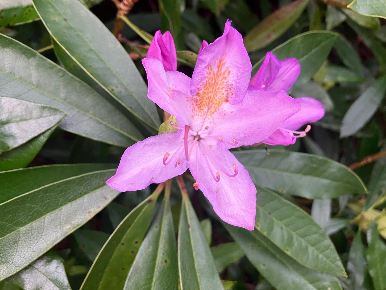
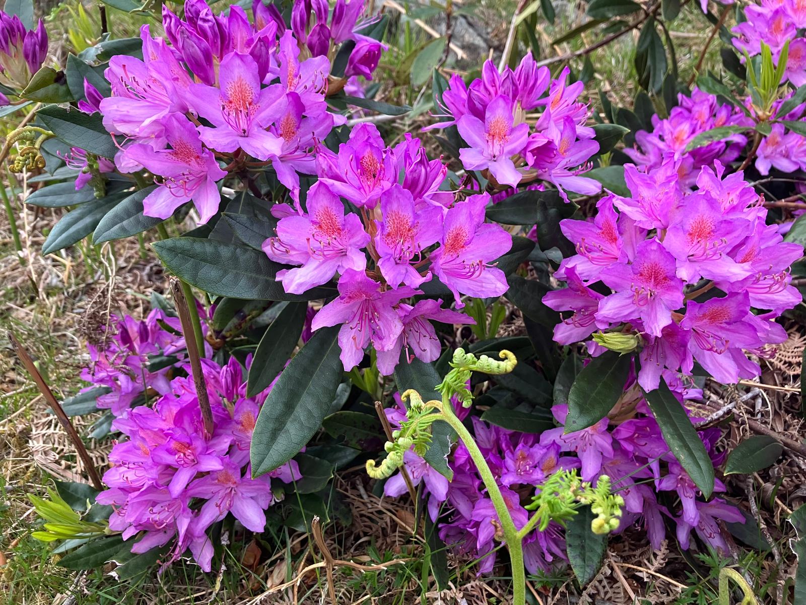
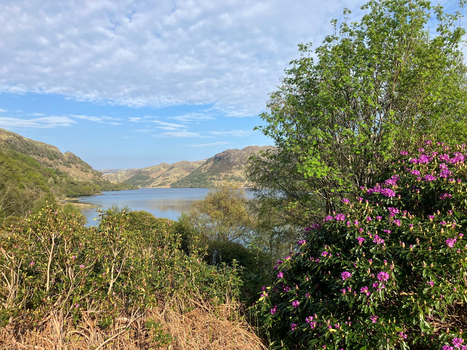
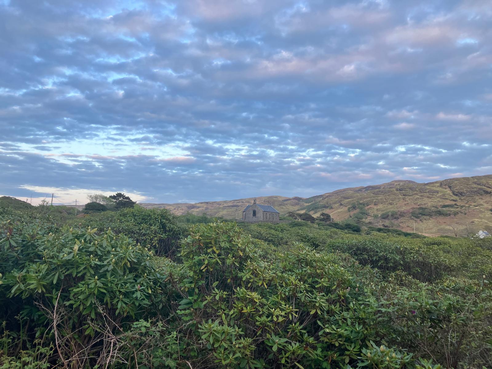
The next day we set off on foot for Loch Uisg, a large lake located in the axis of the Great Glen fault and surrounded by Loch Spelve to the north-east and Loch Buie to the south-west. All along the way we marvel at the rhododendrons which, unlike at home where they are shrub-sized, are made of real dense and richly colored wood. Kinlochspelve church overlooks the east bank and opens before us the horizon of a body of water on which everyone imagines what sport they could practice there: windsurfing, kayaking, wingfoil, kite, dinghy… we aren’t in lack of ideas and the small pontoon next to a lodge confirms to us that we are really not the first to think of it!
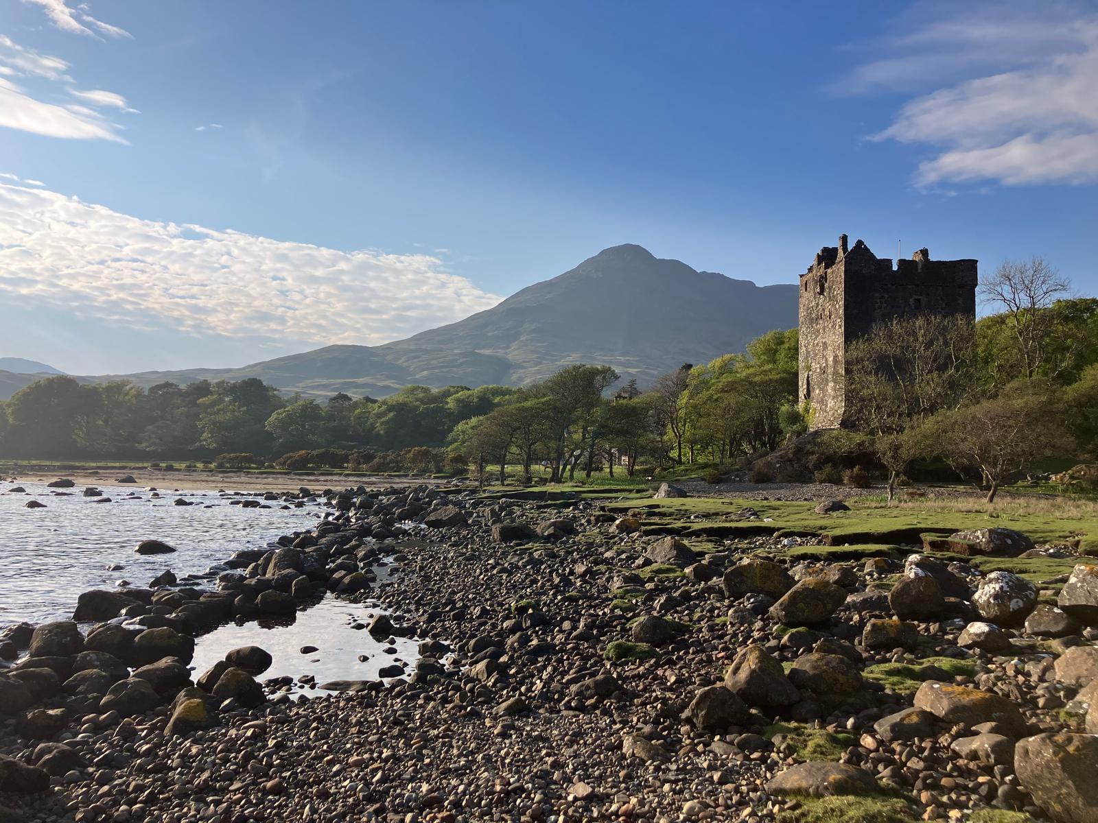
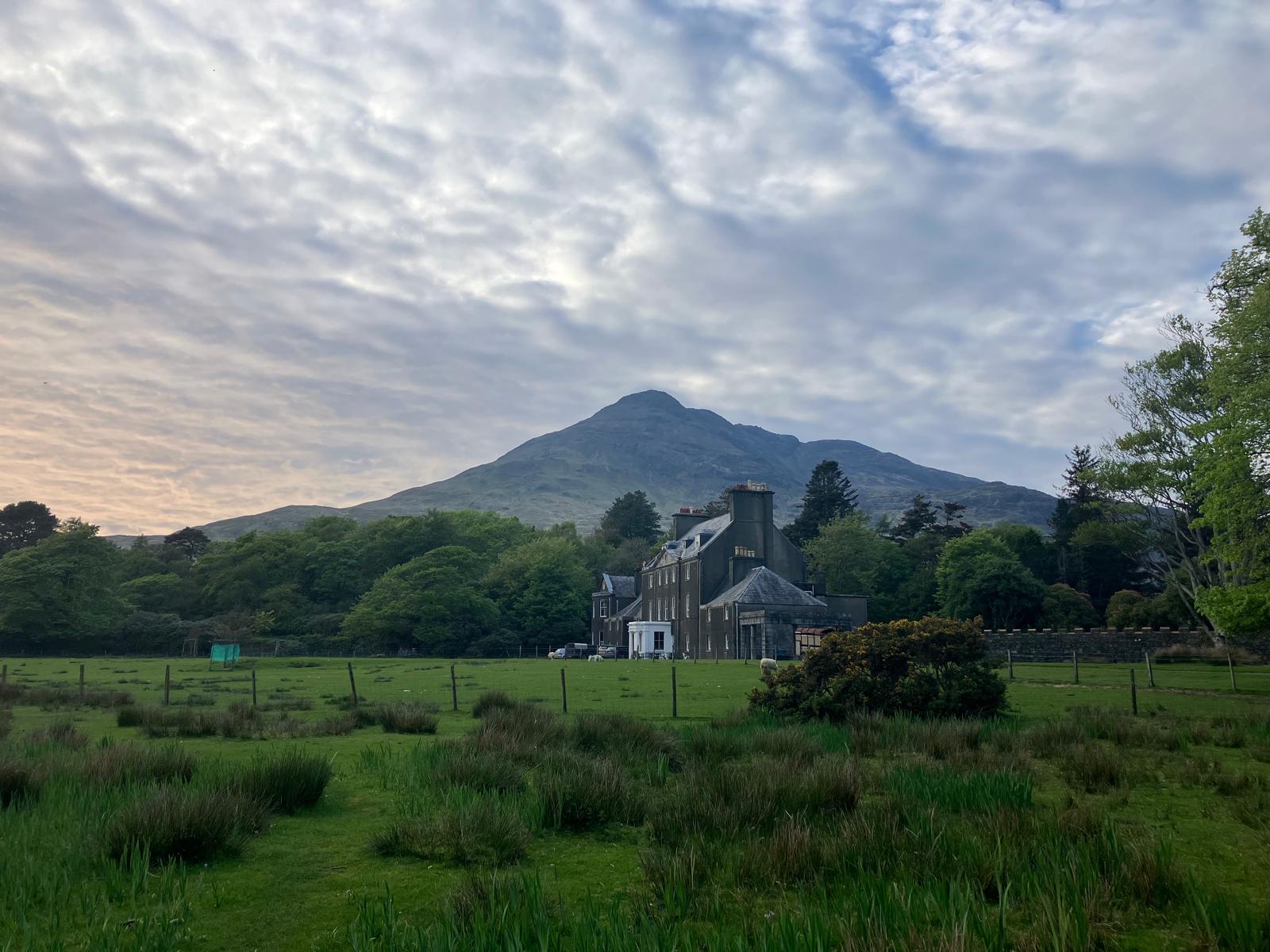
We continue our walk towards Loch Buie to visit Moy Castle of the MacLaine clan of Lochbuie. Built in 1450 by Hector Reaganach Maclean, this three-storey castle, directly supplied with fresh water on the ground floor, was recognized by the King of Scotland in 1494. It was erected a stone’s throw from the bank in order to allow ships to easily access it. A still visible arch of stones served as a fish trap and several large blocks facilitate landing from small boats. It was the scene of clashes such as during the Jacobite revolt of 1689. This castle had to be restored at the end of this period and was also modified over the centuries to improve comfort (e.g. installation of a fireplace in the 16th century). It was only in 1790 that the MacLaine clan of Lochbuie left it in favor of a more comfortable neighboring habitat, once more peaceful times had returned: the Moy house. For several decades the use of Moy Castle was reduced to that of its dungeon as a prison.
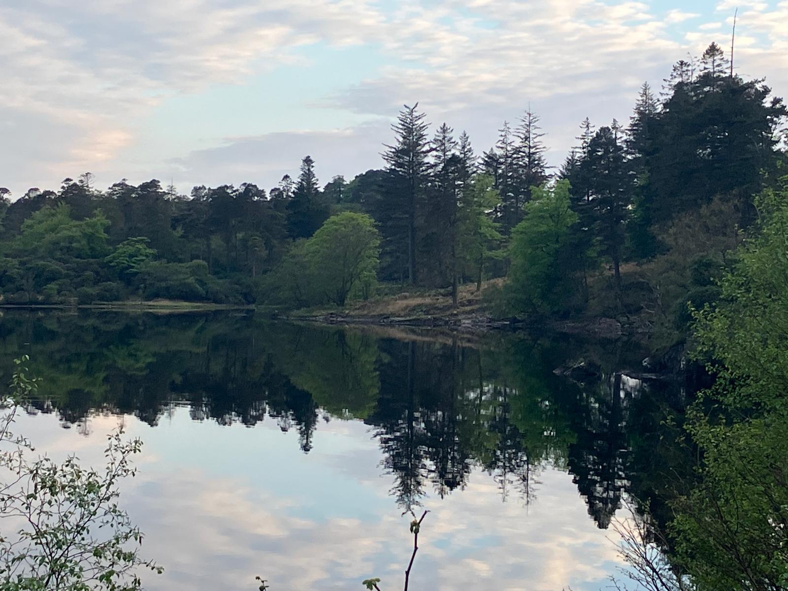
The loch is so beautiful that we decide to return there with Milagro and enjoy a new excursion the next day to the megaliths. On our return to Loch Spelve we are no longer alone at anchor and meet the friendly neighboring crew, a trio of Scots impressed by the size and line of our Milagro. We invite them on board for coffee the next morning, before weighing anchor towards Loch Buie.
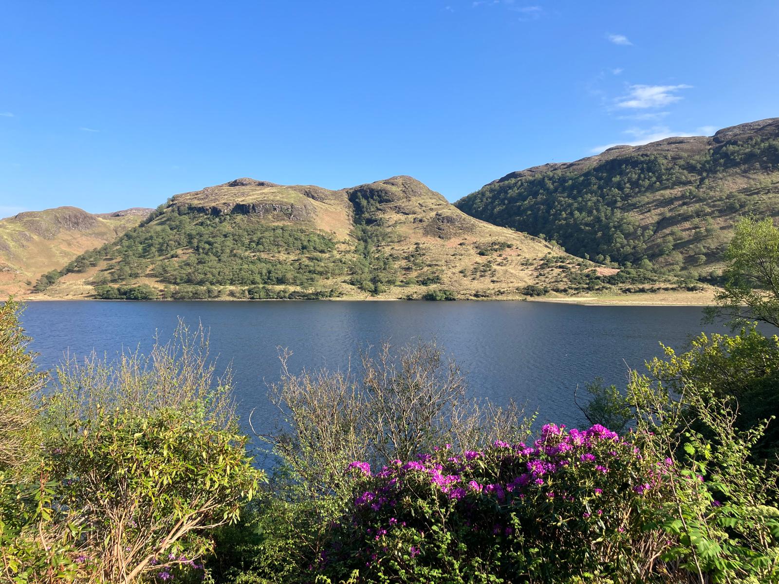
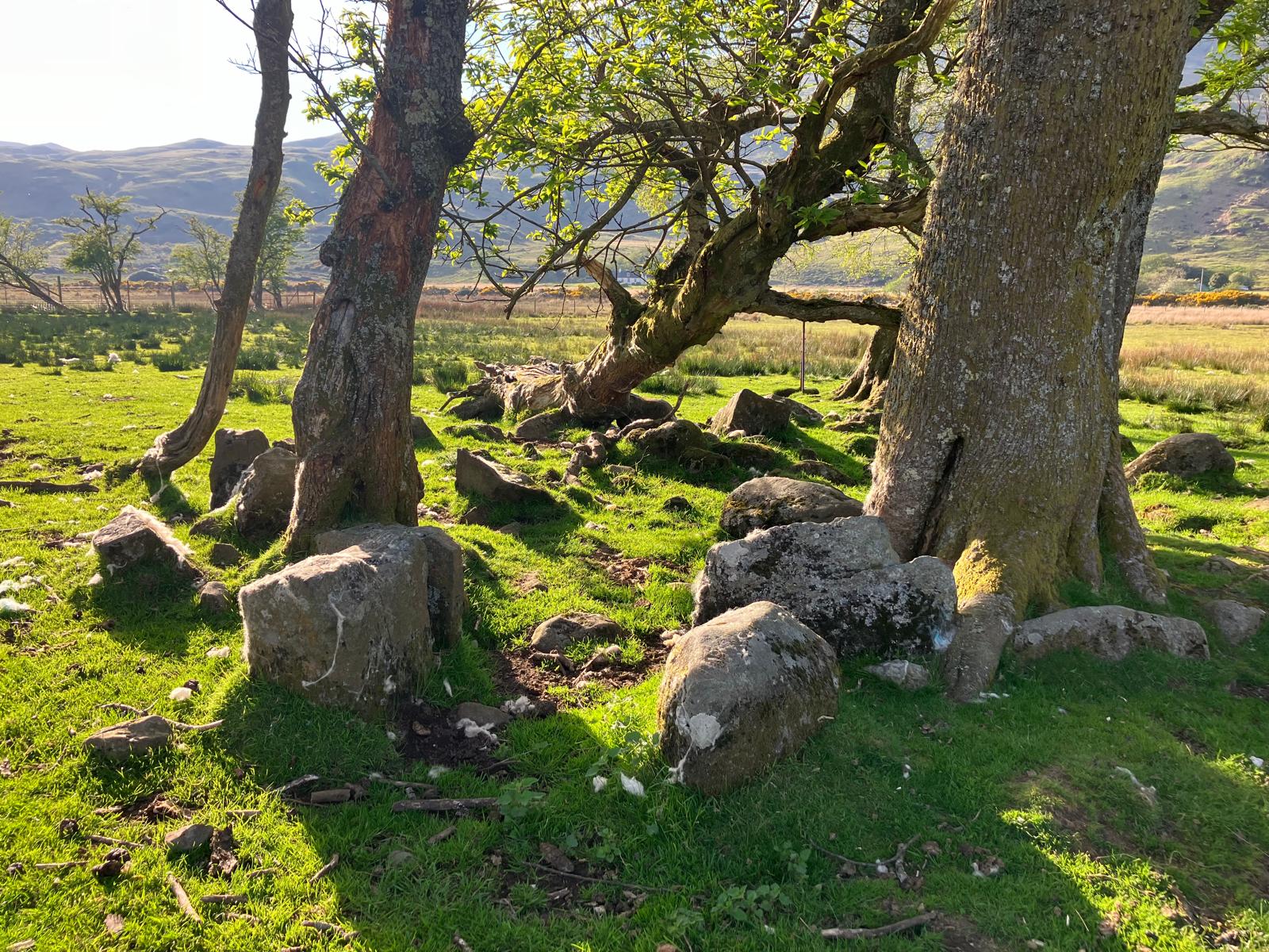
Navigation is across (4-5 Beaufort), leeward of Mull Island. We approach Moy Castle and enjoy a splendid view of the highest peak of the loch: Ben Buie (717m). We drop anchor in an indentation in the loch and disembark to see these famous megaliths. The weather is so beautiful that bathers are enjoying the nearby beach and we are quick to abandon the windbreakers and prefer t-shirts. The walk towards the megaliths leads us to the encounter of a meeting between deer and sheep. We follow the white stones showing us the way to the circle of megaliths. Before arrival, another site is spotted by Lauriane, a few hundred meters away, similar to certain tumuli-type tombs visible within the megalithic site of Saint Just in Brittany (composed of several rooms and an entrance corridor ). The sight of the circle of megaliths fascinates: what does it mean? The lack of scientific consensus on the subject allows everyone to project their imagination and see it as a ritual site, a monument linked to the alignment of the stars or even a gathering place to party!
After dinner at anchor the sky becomes thicker and a little rolling appears to lull us. We prepare for the next navigation to Iona, the sacred island.
Soon we will publish a short video summarizing our stops at Loch Spelve and Loch Buie and incorporating images of the megalith circle.


![[#8 – Ireland–Scotland 2024] from Loch Buie to the sacred Isle of Iona](https://karukinka.eu/wp-content/uploads/2024/07/Iona_LL-1080x675.jpg)