Karukinka will be represented by three members: Mirtha Salamanca (Selk’nam community), José German González Calderón (Yagan community) and Lauriane Lemasson (co‑founder and scientific coordinator). The colloquium will take place at the University of Montpellier, providing a privileged scientific and institutional framework for the presentation of Karukinka’s field‑based toponymy program in southern Patagonia and Tierra del Fuego.
This participation places Karukinka at the heart of a reflection on inclusive toponymy – that is, on the role of place names in the recognition of Indigenous languages, identities, and territories. The association’s work in the channels and fjords of Patagonia has long combined nautical exploration, archival research, and oral history, with the aim of restoring and re‑circulating the original Indigenous toponyms of the region.
In Montpellier, this project will be presented as a concrete example of how toponymy, understood not only as a technical or administrative matter, but as a symbolic act, can contribute to understand better the geographic space and to rehabilitate part of the Indigenous memory. The presence of Mirtha Selk’nam Salamanca and José German González Calderón, as representatives of peoples whose languages and territories were long invisibilized or erased, will give special weight to these words.
Karukinka’s participation in this UNESCO‑framed colloquium also highlights the interdisciplinary and transnational dimensions of its program: links between geography, anthropology, linguistics, history, cartography, and environmental science. By bringing the Patagonian and Fuegian landscapes into the university amphitheater, the association contributes to bridging field work and academic discourse, and to making the southern natives worlds more visible in the international scientific landscape.
The colloquium will thus be an opportunity to share the association’s methodology of collecting, verifying, and restoring place names, as well as to discuss the ethical and practical challenges of working with Indigenous peoples and state institutions. These reflections are intended to support the re‑indigenization of the toponymy of Patagonia and the Cape Horn Biosphere Reserve, and, more broadly, to inspire similar initiatives in other regions where the Indigenous presence has been historically neglected.
In this way, attending the UNESCO Inclusive Toponymy Colloquium in Montpellier is not only a scientific and institutional event for Karukinka, but also a continuation of its long‑standing commitment to the memory and heritage of Indigenous peoples, and to the re‑reading of the map from the perspective of the communities who have lived there for millenias.
The Southern Cross (Crux, Cruz del Sur or Croix du Sud) is one of the most famous, emblematic and culturally rich constellations in the starry sky of the southern hemisphere. Although it is the smallest of the 88 modern constellations, its history, its stellar composition, and its crucial role for southern navigation make it a fascinating subject of study.
Astronomical features
The Southern Cross is not technically a constellation in origin, but an asterism (a distinctive pattern drawn by particularly bright stars). It is now recognized as the constellation of the Cross (Crux). It consists of four main stars that form the ends of the cross, often completed by a fifth, smaller star located between the right arm and the foot of the cross.
Acrux (Alpha Crucis): This is the brightest star in the constellation and the 12th brightest star in the night sky. Located at the base of the cross, it is actually a multiple star system situated about 320 light‑years from Earth, with a combined apparent magnitude of 0.76.
Mimosa (Beta Crucis): Located on the left (western) arm of the cross, this is the second‑brightest star. It lies at about 280 light‑years and has a magnitude of 1.25.
Gacrux (Gamma Crucis): At the top of the cross, Gacrux is a red giant of spectral class M3.5 III. At only 88.6 light‑years, it is the nearest red giant to the Sun and the largest of the five stars. Its magnitude is 1.64.
Imai (Delta Crucis): This star forms the right (eastern) arm of the cross. Its apparent magnitude is 2.79 and it lies 345 light‑years away.
Ginan (Epsilon Crucis): Although often omitted in the strict shape of the cross, this star of magnitude 3.58 lies between Acrux and Imai, at 230 light‑years.
History and mythology
Indigenous cultural significance
Long before Europeans, the Southern Cross held a central place in the cultures of the southern hemisphere:
Aboriginal Australians: The stars of the cross appear in many Dreamtime stories and served as a calendar and seasonal guide. In certain traditions, the Cross and the “Dark Nebula” (a dark nebula nearby) form the head of the Celestial Emu.
Māori of New Zealand: In Māori culture, the Cross is known as Te Punga (“the anchor”), linked to the great canoe (the Milky Way) of Tama‑rereti.
Incas: The Inca Empire knew it as Chakana (the “stair‑cross”), a deep spiritual and cosmological symbol connecting the underworld, the earthly world and the divine.
European discovery
In antiquity, the Southern Cross was visible from the Mediterranean. The Greeks, including Ptolemy, regarded it as part of the constellation Centaurus. Because of the precession of the equinoxes (the slow movement of the Earth’s rotational axis), it gradually slipped below the European horizon and was forgotten.
It was “rediscovered” during the great European maritime expeditions at the dawn of the 16th century. The Venetian navigator Alvise Cadamosto noted it in 1455, calling it the carro dell’ostro (“southern chariot”), although his drawing was imprecise. The Portuguese astronomer and physician João Faras is generally credited with being the first European to draw it correctly in May 1500, from the coasts of Brazil. The Florentine navigator Amerigo Vespucci also described it in a letter in 1503.
An emblem of southern territories
Beyond its astronomical and nautical function, the Southern Cross has become a major emblem, serving as an identity marker for the extreme southern territories of the American continent. Its representation conveys a deep geographical and memorial rooting.
It thus appears at the heart of the official symbols of Patagonia and the Fuegian archipelago.
On the flag of the Chilean region of Magallanes and Chilean Antarctica, the white constellation stands out against a deep‑blue background, above snowy peaks and a golden steppe, symbolizing the southern position of the region.
Across the border, the flag of the Argentine province of Tierra del Fuego, Antarctic and South Atlantic Islands likewise displays the five stars of the Southern Cross tilted on a blue field, here associated with the silhouette of an albatross in flight, an allegory of freedom and local marine fauna.
In both cases, the Southern Cross functions as the seal of a shared belonging to the southern world and its maritime history.
In a more free‑flowing, contemporary vein, the Southern Cross appears even in the visual identity of our association, Karukinka. Without seeking the rigor of an official emblem, the logo pays it a clear tribute. This choice is no accident: it is an invitation to travel, a discreet reminder of our sub‑Antarctic fields of exploration and of our attachment to both maritime and Indigenous knowledge in this land at the end of the world.
An invaluable navigation tool
The major historical importance of the Southern Cross lies in its use for oceanic navigation. In the northern hemisphere, Polaris points precisely to the celestial north pole. The southern hemisphere lacks such a bright star near the pole, which made nighttime orientation complex for early sailors.
How to find the south celestial pole?
The Southern Cross serves as a “pointer” toward the south celestial pole. Mariners and navigators use a simple geometric method:
Draw an imaginary line joining Gacrux (the top of the cross) to Acrux (the base).
Extend this line downward by about 4.5 times the distance separating these two stars.
This imaginary point in the sky lies very close to the south celestial pole.
To confirm this point, navigators rely on two very bright neighboring stars, Alpha and Beta Centauri (the “Pointers”). By drawing a line perpendicular to the midpoint of the segment joining these two Pointers, the intersection of this line with the one descending from the Cross gives the exact location of the south celestial pole.
This technique was essential for Polynesian navigators during their incredible transoceanic voyages. During the first circumnavigation (1519–1522), Magellan’s expedition also learned and used these techniques based on the Southern Cross to navigate the vast expanse of the Pacific and the Southern Ocean. Argentine gauchos similarly used it to orient themselves at night across the vastness of the Pampa and Patagonia.
Today, the importance of the Southern Cross is such that it has become a national emblem. It features prominently on the flags of several nations in the southern hemisphere, including Australia, New Zealand (which displays only the four main stars), Brazil, Papua New Guinea and the Solomon Islands.
The association Cape Horn au Long Cours and the website Cap‑Horniers Français now represent one of the most valuable independent resources for understanding the epic of large French merchant sailing ships and the seafarers who crossed Cape Horn. Through meticulous, volunteer‑driven research, the site documents vessels, voyages and crews, restoring a voice to these long‑distance sailors whose memory might otherwise have remained confined to archives and a few museum cases.
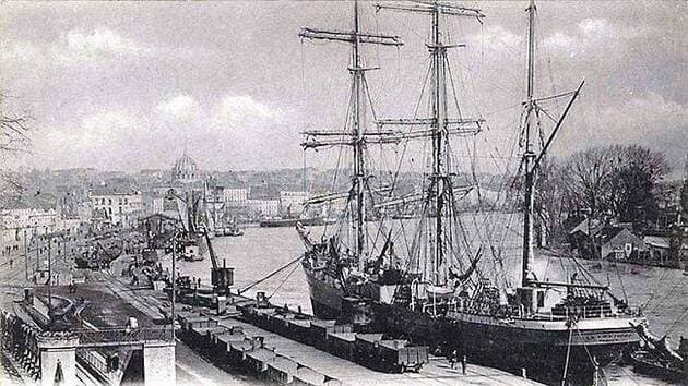
Nantes Port at the end of the 19th century (Quai de la Fosse) Le Coat Collection
A living memory of French Cape Horners
The term “Cape Horners” (or cap‑horniers) refers both to the large merchant sailing ships and the sailors who rounded Cape Horn between roughly the mid‑19th century and the 1920s, sailing between Europe and ports in the Pacific Ocean. These three‑ or four‑masted steel windjammers faced extreme conditions—fierce winds, heavy seas and freezing cold—especially when they beat against the prevailing westerlies to pass from east to west around the Horn.
For over a century, until the 1920s, the Cape Horn route was one of the great arteries of global maritime trade: French sailing ships carried guano and nitrates from Chile and Peru, cereals from Australia and California, lumber from North America, metals and nickel ore, among many other cargoes. Long before steam power and the Panama Canal, these tall ships shaped the commercial networks of the era, leaving behind a legacy of courage and endurance.
The Cape Horn au Long Cours association and its roots
The association Cap Horn au Long Cours (CHLC) inherits its spirit from the International Association of Cape Horn Captains (AICH), originally the Amicale Internationale des capitaines au long cours Cap‑Horniers, now dissolved along with the last generation of sailing‑ship masters who created it. Carrying on that legacy, CHLC has as its mission “to preserve and make known the heritage of the Cape Horners,” whether ships, routes, trades or human itineraries.
To fulfill this mission, the association launched and maintains the website caphorniersfrancais.fr, entirely devoted to French merchant sailors who sailed around Cape Horn under sail. The site states a clear, ambitious goal: to document, in the longer term, all the voyages of all the French Cape‑Horn sailors on all the French merchant sailing ships that rounded the Horn.
Independent, volunteer‑based documentation work
The work behind Cap‑Horniers Français is carried out in a fully independent, volunteer‑led manner. The team gathers and cross‑checks multiple sources: shipping company archives, logbooks, crew lists, travel journals, family photographs, private letters, and corrections or additions sent by descendants of sailors.
The site’s authors openly acknowledge the “monumental” scope of the task and the fact that it will take years of work, inviting the public to contribute documents, personal memories, or any corrections to existing entries. This participatory approach turns the project into a genuinely collaborative maritime‑history endeavor, where families, local historians and enthusiasts progressively enrich a unique documentary database.
Ships, voyages, crews: a growing corpus of documentation
One of the site’s main strengths is its effort to reconstruct, vessel by vessel and voyage by voyage, the itineraries and the lists of mariners aboard. The stated aim is to move Cape Horners beyond being anonymous silhouettes in old photographs and to see them as individual men, identifiable by name and placed back in the context of their long‑distance campaigns.
The site also highlights narratives and first‑hand accounts, such as the story of Captain Abel Guillou of the three‑masted steel ship Bretagne, wrecked at Cape Horn in August 1900 after two and a half months of battling the elements, with the crew later rescued by the British four‑masted windjammer Maxwell. These stories give concrete flesh to the dangers of the Cape Horn route and illustrate the values of courage, resilience and solidarity that the association wishes to transmit as part of the Cape‑Horners’ heritage.
Getting Cape Horners out of the museums
CHLC does not limit itself to an online database; it also seeks “to get Cape Horners out of museums” by bringing their stories directly to the public through conferences, temporary exhibitions, and various events held across France. These outreach activities rely on the association’s research to tell the history of long‑distance sailors beyond the display of objects, placing the human dimension—words, experiences and personal trajectories—back at the heart of the narrative.
This itinerant mediation helps reconnect port cities and maritime regions with their Cape‑Horn sailing heritage, especially in the towns and ports that played a significant role in the sail‑trade economy. It also offers descendants of sailors a space where they can rediscover traces of their ancestors and understand the concrete context of their voyages.
A major historiographical and heritage contribution
From a scholarly perspective, the work of Cap‑Horniers Français fills a gap between the “official” history of merchant shipping (statistics, fleet data, major trade routes) and the lived, often under‑documented history of crews at the individual level. By reconstructing voyages one by one and identifying the sailors, the association produces a fine‑grained micro‑history of sailing around Cape Horn.
This approach makes it possible to study recruitment networks, regional origins, the rhythm of voyages, long or short careers, wrecks and homecomings, and more broadly how the global economy of nitrates, cereals or timber translated into concrete human trajectories. It further provides a valuable resource for researchers in social history, maritime geography, port studies or maritime anthropology.
Cape Horn, a strategic node in global sail‑trade routes
To understand the association’s importance, it is essential to recall Cape Horn’s role in global maritime networks before the era of steam and the Panama Canal. From the late 15th century onward, and more intensively from the 19th century, powers seeking new maritime routes for spices, and later guano, nitrates and other raw materials, pushed their fleets south of the Americas.
Throughout the 19th and early 20th centuries, French Cape‑Horn windjammers regularly sailed between Europe and the Pacific, rounding Cape Horn twice a voyage in many cases. These routes were crucial for the nitrate and cereal trades, but they also demanded exceptional seamanship in the “Furious Fifties” and “Roaring Forties,” which explains the enduring prestige attached to Cape‑Horn sailors.
Nantes, a major ship‑owning port and Horn‑route hub
Within this story, Nantes occupies a special place as a major ship‑owning port and shipbuilding center on the Loire estuary. In the 19th century, shipyards around Nantes—including the Chantiers de la Loire and Dubigeon—built large steel sailing ships intended for long‑distance trade, including routes toward the Pacific and the Horn.
Nantes’ port landscape developed around the quays of the Loire, the activities of ship‑owners, river barge traffic, and large merchant vessels operating in an increasingly global economy. The presence of a Rue des Cap‑Horniers in Nantes symbolically underscores the city’s historic link with the sailors who departed on these extreme voyages.
The research carried out by Cap‑Horniers Français helps reconnect these port‑city realities with individual lives: many of the Cape‑Horn sailors, officers and captains featured on the site were from Nantes, Loire‑Atlantique, or other Atlantic ports, their careers scattered across registers, logbooks, and family testimonies that the association brings to light.
Saint‑Nazaire, an oceangoing gateway to the Horn
With the rise of the Port of Saint‑Nazaire in the middle of the 19th century under the Second Empire, the Loire estuary gained a modern oceangoing outport that gradually expanded and complemented the facilities further upstream. Created in 1856, Saint‑Nazaire became a key element of the greater Nantes–Saint‑Nazaire maritime port, featuring docks, dry docks, and later major shipyards.
Although Saint‑Nazaire is now best known for large‑scale shipbuilding, including cruise liners, its origins lie in a broader maritime and long‑distance economy, including the transit and outfitting of sailing ships bound for the Atlantic and the Pacific. At the height of the sail‑ship era, the Nantes–Saint‑Nazaire port complex formed one of France’s main gateways toward the South Atlantic, the Pacific, and therefore the Cape Horn route.
The work of Cap‑Horniers Français—by documenting ship by ship the campaigns to the Pacific—helps highlight this dimension: one can follow vessels built or owned in the region, crews recruited from coastal villages along the Loire, and the long journeys that ultimately led them to round Cape Horn.
A resource for researchers, institutions and families
The site is freely accessible and serves as a premier‑quality resource for historians, students, maritime museums, but also for genealogists and families seeking to trace an ancestor’s seafaring career. The fine‑grained level of information—ship names, campaign dates, itineraries, onboard narratives, testimonies—allows for both detailed and cross‑cutting kinds of research.
By making this corpus available, Cap‑Horniers Français also contributes to the valorization of maritime heritage for local authorities, ports, and memory‑related sites, which can draw on the data for exhibitions, urban routes, commemorations, or educational projects. In doing so, the association positions itself as a bridge between archives, territories and the wider public.
A call for contributions and the future of the Cape‑Horn legacy
With full awareness of the immensity of the task, the association emphasizes that this work is evolving and incomplete, inviting anyone who possesses documents, photos, notebooks, crew lists, or family stories to contact them and help enrich and correct the published information. This openness underlines the collective nature of the project: the history of Cape Horners is no longer reserved for specialists alone, but becomes a shared memory to which everyone can contribute.
At a time when commercial sailing has vanished before the rise of mechanical propulsion, this independent research stands as a bulwark against the forgetting of a maritime world now gone, yet one that has shaped French port cities, estates and coastal cultures from Nantes and Saint‑Nazaire to the distant shores of the Pacific. By rigorously documenting Cape‑Horn sailing ships and their crews, Cap‑Horniers Français provides an irreplaceable tool for understanding this history and transmitting it to future generations.
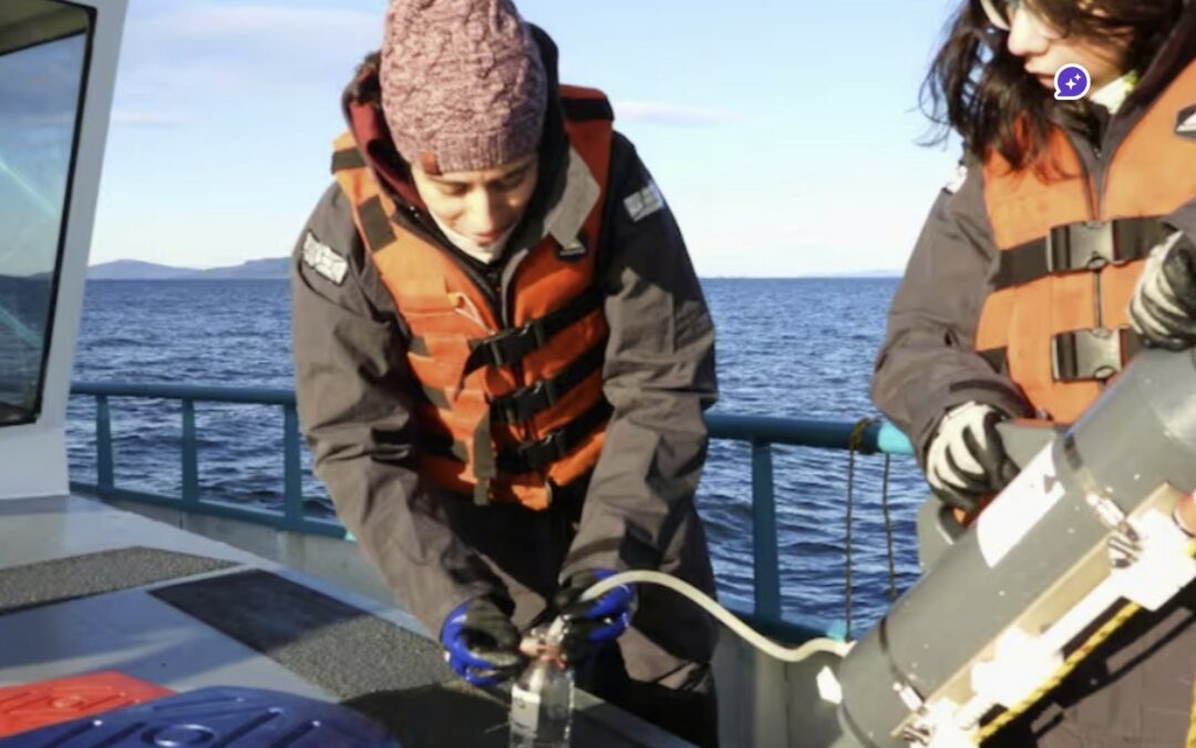
A study conducted by Conicet in the Beagle Channel could be a turning point for aquaculture production in Tierra del Fuego. The analysis of variables such as water temperature, salinity, and oxygen concentration aims to lay the foundations for the first industrial-scale mussel farm in Ushuaia, as part of a project led by Newsan Food. #mussels Beagle Channel
The study is led by Irene Schloss, a specialist in biological oceanography, with a team from the Southern Scientific Research Center (Cadic). The researchers are studying environmental conditions in areas near Puerto Almanza, where mussels already grow naturally, and evaluating other areas with production potential. This species is native to the Beagle Channel and has great potential for regional aquaculture.
The work is part of a High-Level Technological Service (STAN) requested by Newsan Food, which has been developing fishing activities in the province for 15 years and, in the last five years, has made progress in aquaculture for domestic supply according to a sustainable model. Last February, the company led by Rubén Cherñajovsky launched the first national production of industrial mussels.
“Mussels are sensitive marine organisms that require optimal environmental conditions to grow and thrive. It is therefore essential to understand and evaluate the environment in which their cultivation is planned, to ensure the long-term success of the productive activity,” explains Schloss.
The study considers key environmental and biological variables: temperature, salinity, oxygen and ammonium concentration, presence of chlorophyll and phytoplankton, with an emphasis on toxin-producing species (red tide). All this aims to determine whether the conditions in the channel are suitable for the development of this industry.
“Studying the marine environment of the Beagle Channel is important for many reasons, but it is even more valuable that these studies can have a real impact on productive activities in the southernmost region of the continent. When we work together, everyone wins: better decisions are made and science translates into concrete results for society,” adds the researcher.
For field operations, the Scientific Research Vessel (BIC) Shenu serves as a base for navigation and surveys, with a monthly campaign at five coastal stations between Puerto Almanza and the east of Gable Island, opposite Puerto Williams (Chile). The project plans twelve campaigns until October. The ship is equipped with multiparameter instruments (CTD, light and chlorophyll sensors) as well as equipment for storing and processing samples taken at depths of between 5 and 8 meters, which are then analyzed in Cadic's laboratories.
On the Newsan Food side, director Fabio Delamata explains: “The company's objective is to conduct a study of the marine environment to consolidate the creation of an aquaculture development hub based on sustainability, environmental protection, and an industrial perspective. Working with Conicet means relying on data and information to achieve a solid, reliable, and long-term result.”
The company has invested nearly $10 million in cultivation lines, boats, and harvesting and seeding platforms, as well as an operational hub in Puerto Almanza. The overall plan calls for a $17 million investment to expand production with new collection and breeding lines.
The project aims to meet local demand, which fluctuates between 300 and 400 tons of mussels per year, currently imported from Chile, and to open the door to exports. Last summer, Newsan sent a batch of 10 tons of mussels cultivated in the Beagle Channel to Buenos Aires, whole, frozen, and pre-cooked in the channel's water.
The results of Conicet's research could not only diversify Tierra del Fuego's productive matrix, but also generate employment and raise environmental awareness in the community. “This would strengthen environmental awareness as an alternative for diversifying the productive matrix and encourage sustainable development in Almanza,” emphasize Cadic members.
The Beagle Channel, known to the Yaghan people as Onashaga (“channel of the Ona hunters,” i.e., their Selk'nam neighbors from Tierra del Fuego), is one of the planet’s outstanding maritime passages. This interoceanic strait, approximately 270 kilometers long, connects the Atlantic and Pacific oceans at the very southern tip of South America, separating the main island of Tierra del Fuego from an archipelago of smaller islands between 54°50′ and 55°00′ south latitude.
The east part of the Beagle channel (c) Karukinka
For us, who regularly sail these legendary waters, Onashaga—the Beagle Channel—means much more than a simple maritime passage: it’s a world of its own, where two oceans meet and where seven millennia of Yagan navigation still resonate.
Table des matières
The genesis of the landscape: a glacial heritage
When ice sculpted the channels
The formation of the Beagle Channel is a prime example of Quaternary glacial sculpting, which has shaped one of the most spectacular southern hemisphere landscapes. During repeated Pleistocene glaciations, glaciers hundreds of meters thick excavated valleys like Carbajal and Lake Kami (Fagnano), creating the region’s complex topography.
Photography of the Carbajal Valley by Lauriane Lemasson, during the 2013 expedition in Argentine Tierra del Fuego
The glacier responsible for forming the Beagle Canal moved from west to east, fed by the Darwin Range, where glaciers and snowfields—remnants of this genesis—can still be seen today. This glacial process left behind moraine deposits in the shallower areas, especially around Gable Island and off the Ushuaia Bay, creating today's bathymetric complexities.
The tectonic structure underlying the channel is a longitudinal tectonic valley, later modified by glacial action. The combination of tectonic and glacial processes resulted in a morphology with semi-isolated basins as deep as 400 meters, separated by shallow topographic sills that control water mass circulation.
A complex submarine architecture
The Beagle Channel’s bathymetry reveals a complex architecture dominated by a series of shallow sills, dividing the channel into several distinct micro-environments. In the western sector, the Diablo Island sill (approx. 50 meters deep) and the Fleuriais Bay sill (about 100 meters) separate the northwestern and southwestern branches from the central sector.
This bathymetric setup generates a complex circulation system, with sills acting as barriers that limit the exchange of deep water masses, creating micro-environments with distinctive physical, chemical, and biological properties.
It is this diversity of habitats that makes the Beagle Channel such a rich and unique ecosystem, as explained by Centro IDEAL researchers who have studied these waters for years.
East part of the Beagle channel
Hydrographic system
The meeting of oceans
The Beagle Canal acts as an interoceanic corridor that facilitates the transport of surface waters from the Pacific to the Atlantic, a flow mainly driven by the difference in sea level between the two oceans and the influence of strong westerly winds within the Antarctic Circumpolar Current.
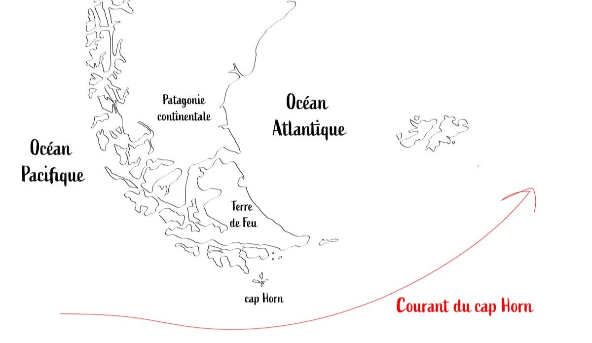
The Cape Horn current is the primary source of water entering the channel, bringing subantarctic water (SAAW) at depths greater than 100 meters along the edge of the Patagonian Pacific shelf. This water enters via a submarine canyon at the western mouth of the channel, characterized by temperatures of 8–9°C, salinity above 33, and relatively low oxygen concentrations.
Map illustrating the Cape Horn current (c) Karukinka
Waters that tell the story of the climate
Freshwater input from the Darwin Cordillera icefield generates a two-layer system, with a pronounced pycnocline separating vertical phytoplankton fluorescence. This estuarine water is cold (4–6°C), nutrient-poor, and highly oxygenated.
Time series analyses reveal that the annual cycle explains 75–89% of ocean temperature variability, while the atmospheric cycle explains 53% of its variability.
These data allow us to understand how the channel reacts to climate change, emphasize oceanographers monitoring these waters.
A sanctuary for marine biodiversity
The realm of marine mammals
The channel hosts an exceptional diversity of marine mammals, internationally recognized as an important marine mammal area (IMMA), covering 26,572 km² from the channel to Cape Horn. This area is home to at least eleven primary marine mammal species, plus eight supporting species.
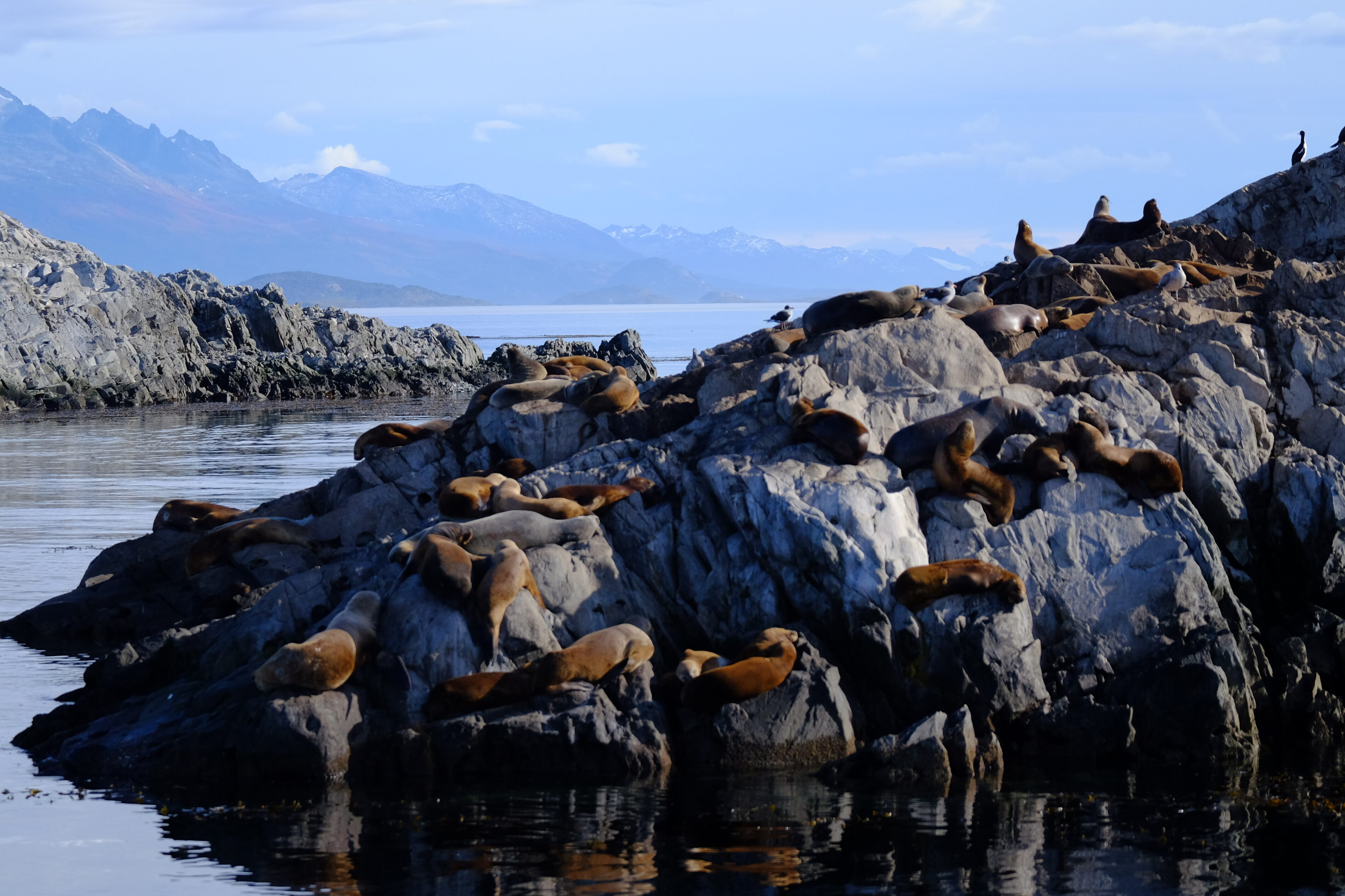
Among the year-round resident species are three small cetaceans: the Peale’s dolphin (Lagenorhynchus australis), the dusky dolphin (L. obscurus), and the Burmeister’s porpoise (Phocoena spinipinnis), along with two pinnipeds: the South American sea lion (Otaria byronia) and the South American fur seal (Arctocephalus australis).
Colony of South American fur seals in the Beagle Channel, near Ushuaia Bay, photographed in April 2025 during a sailing expedition
We have had the chance to observe these Peale’s dolphins during our voyages across Patagonia’s channels, from the channel’s eastern mouth to Cook Bay at its southwestern end. Their close association with kelp forests is fascinating: they undertake 40.5% of their feeding and 14.3% of their hunting behaviors there.
The underwater kelp forests
The underwater forests of Macrocystis pyrifera, locally known as “cachiyuyos,” are among the channel’s most important ecosystems, extending from the Valdés Peninsula to Tierra del Fuego. These forests provide a critical habitat, acting as nursery grounds, refuges, and feeding areas for an exceptionally diverse range of marine species.
Doctoral research by Adriana Milena Cruz Jiménez revealed the complexity of fish assemblages associated with these forests, examining various strata: the lower area at the holdfast and the mid-water area at the fronds.
The ichthyological diversity found in these kelp forests highlights their vital role in marine biodiversity, explains this specialist.
A delicate balance under threat
The pattern of nutrient distribution in the Beagle Channel varies distinctly among its water masses. The system is notably nitrate-limited, with an N:P ratio of 8.42, consistent across all water masses. This directly influences the channel’s primary productivity.
Phytoplankton biomass is generally moderate and limited to the upper pycnocline in the western sector, while mixing over sills disrupts stratification, pushing phytoplankton cells beneath the photic zone, which can limit primary production.
Local scientists insist that understanding these mechanisms is crucial to preserving the unique balance of this ecosystem.
The Yagan cultural heritage: the Onashaga (Beagle) Channel
Seven millennia of navigation
The name Onashaga means “channel of the Ona hunters” in the Yagan language and reflects the profound connection between this maritime people and these waters for around 7,000 years. The Yagan developed a nomadic culture based entirely on exploiting marine resources and constant navigation of the Fuegian archipelago, adapting to an environment Europeans found utterly inhospitable.
When we sail these waters, we still feel the presence of those ancient navigators, as our crew members testify. Their traditional territory extended from the southern coast of the main Tierra del Fuego island (Onaisin) to the Cape Horn archipelago, including the Onashaga. This toponym is one of the many native place names erased from official maps by colonization, which we must now reclaim to restore meaning rooted in the land’s first inhabitants.
The channel as an archaeological witness
Archaeological evidence along the Beagle Channel reveals human occupation stretching back millennia, with shell middens, lithic tool workshops, fish traps, and ancient campsites.
Notable archaeological sites include evidence of ancient Yagan settlement at places like Wulaia Bay on Navarino Island, indicating occupation over 7,000 years ago.
The legacy of great explorations
In the footsteps of Darwin and FitzRoy
The channel is named after HMS Beagle, the British ship that conducted the first hydrographic survey of southern South America’s coasts from 1826 to 1830. The European discovery of the channel occurred in April 1830, when the Beagle was anchored in Orange Bay (southeast Hoste Island).
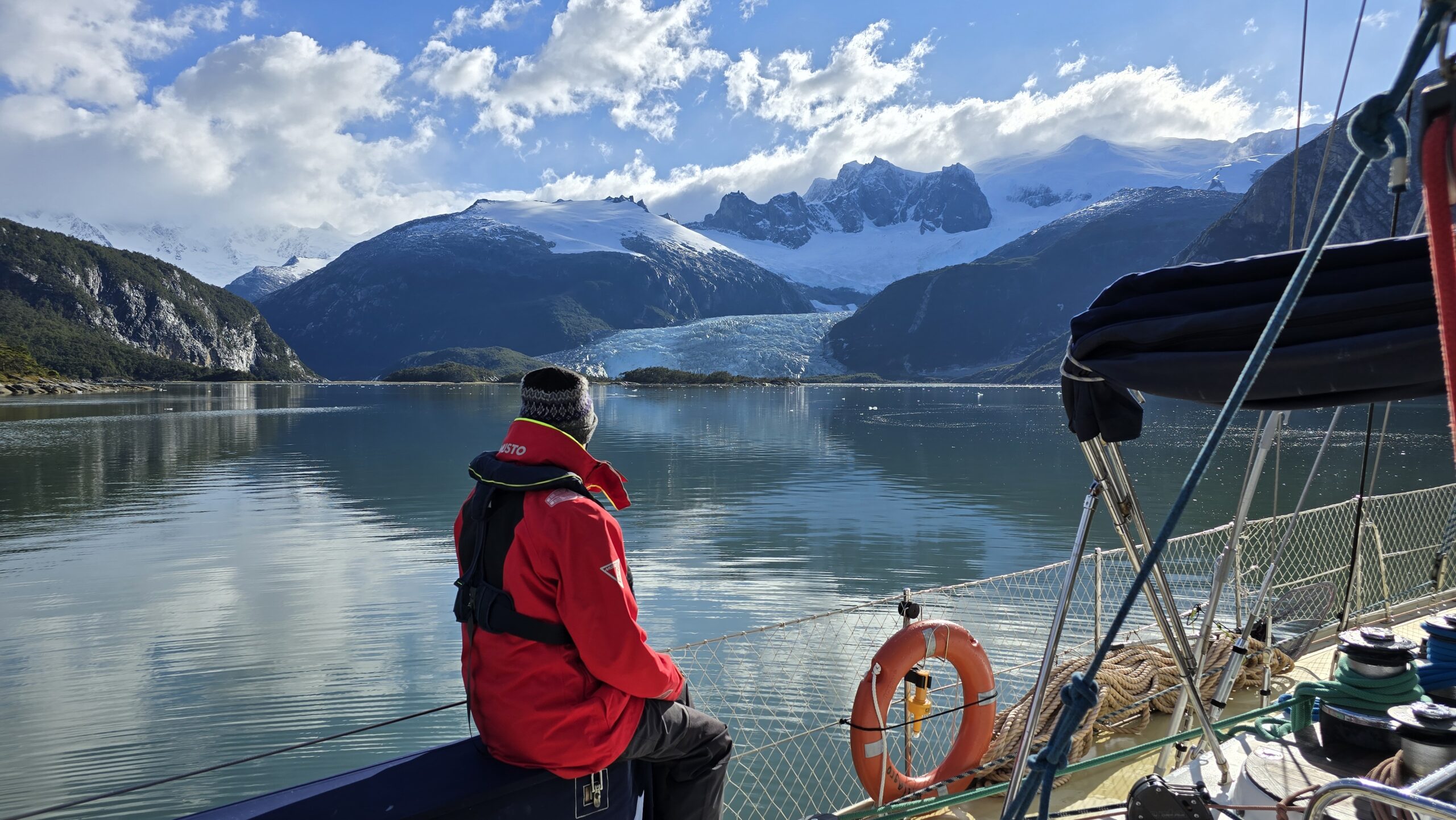
During the second expedition (1831–1836), FitzRoy brought along Charles Darwin as a self-financed naturalist. Darwin saw his first glaciers there in January 1833, writing in his journal: “It is almost impossible to imagine anything more beautiful than the beryl-blue of these glaciers, especially contrasted with the dead white of the upper snow stretches.”
And to travel there regularly... it is always a wonder! Patagonia sailing expedition, February 2025 (Karukinka)
Darwin’s meticulous observations of the region’s geology, fauna, and indigenous populations provided key evidence for his understanding of adaptation and geographic species distribution.
The channel thus became one of the seminal natural laboratories in the history of natural sciences.
From mapping to geopolitical conflict
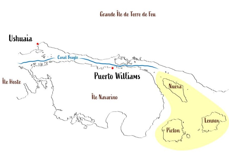
The hydrographic surveys by Captain FitzRoy and crew laid the groundwork for modern navigation in the region, followed by those from the Cape Horn Scientific Mission. However, this mapping precision also revealed the strategic importance of the channel, which would become a historic source of geopolitical tensions between Chile and Argentina.
The Beagle conflict of 1978 brought the nations to the brink of war over three small islands—Picton, Lennox, and Nueva—whose sovereignty would determine control over vast maritime territories. The dispute was resolved by papal mediation, with Pope John Paul II playing a crucial role, leading to the treaty of peace and friendship of 1984.
In yellow, the islands involved in the Beagle Conflict of 1978
Modern science in the service of knowledge
A monitored natural laboratory
Today, the channel is one of the best-studied subantarctic marine systems, serving as a comprehensive regional sentinel of global change. Since October 2016, Chile’s Austral University’s Centro IDEAL has conducted annual hydrographic transects from the western end to Yendegaia Bay.
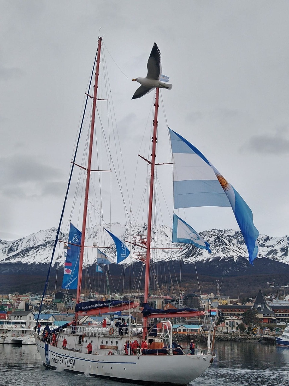
A major milestone was achieved in July–August 2017 with the first complete, high-resolution oceanographic survey along the entire channel, carried out through cooperation between Centro IDEAL and an Argentine expedition on the research vessel Bernardo Houssay. This international collaboration generated, for the first time, a complete hydrographic section of the channel, say the researchers involved.
The sailing vessel Bernardo Houssay, of the Argentine Naval Prefecture, upon its arrival at the port of Ushuaia in 2021 (source)
Unique scientific challenges
Research in the Beagle Channel faces unique challenges due to its remote location, complex geomorphology, and shared jurisdiction between Chile and Argentina, historically limiting coordinated research. Future needs include studies on processes within each semi-enclosed basin and implementation of coupled atmosphere-ocean-glacier models to determine residence times.
Such research is crucial to understanding how this ecosystem will respond to future climate change.
Threats and conservation issues
The challenges of climate change
This channel faces unprecedented threats from climate change: rising temperatures, shifting precipitation patterns, and ocean acidification, all threatening the ecosystem’s delicate balance. Glacier retreat has accelerated dramatically in recent decades, altering freshwater contributions and potentially affecting marine productivity.
Changes have already been observed during our expeditions: the retreat of glaciers between 2018 and 2025 left a lasting impression. Scientists closely monitor these changes, using the region as a natural laboratory to understand wider impacts of climate change.
The salmon farming controversy
The expansion of the salmon farming industry into the region has been categorically rejected by organizations grouped within the Forum for the Conservation of the Patagonian Sea, which express concern over potentially catastrophic and irreversible damage to one of the region’s most precious marine ecosystems.
We strongly support this position: the channel’s pristine waters are home to one of the world’s greatest biodiversity reserves, with great heterogeneity in coastal-marine habitats containing numerous understudied marine invertebrates and vertebrates. Introduction of non-native species such as salmon is considered “terrible and risky” for this ecosystem by leading researchers. Fish-farm salmon escapes upstream have led to “wild salmon” appearing in the Cape Horn Biosphere Reserve, now threatening endemic species such as robalo.
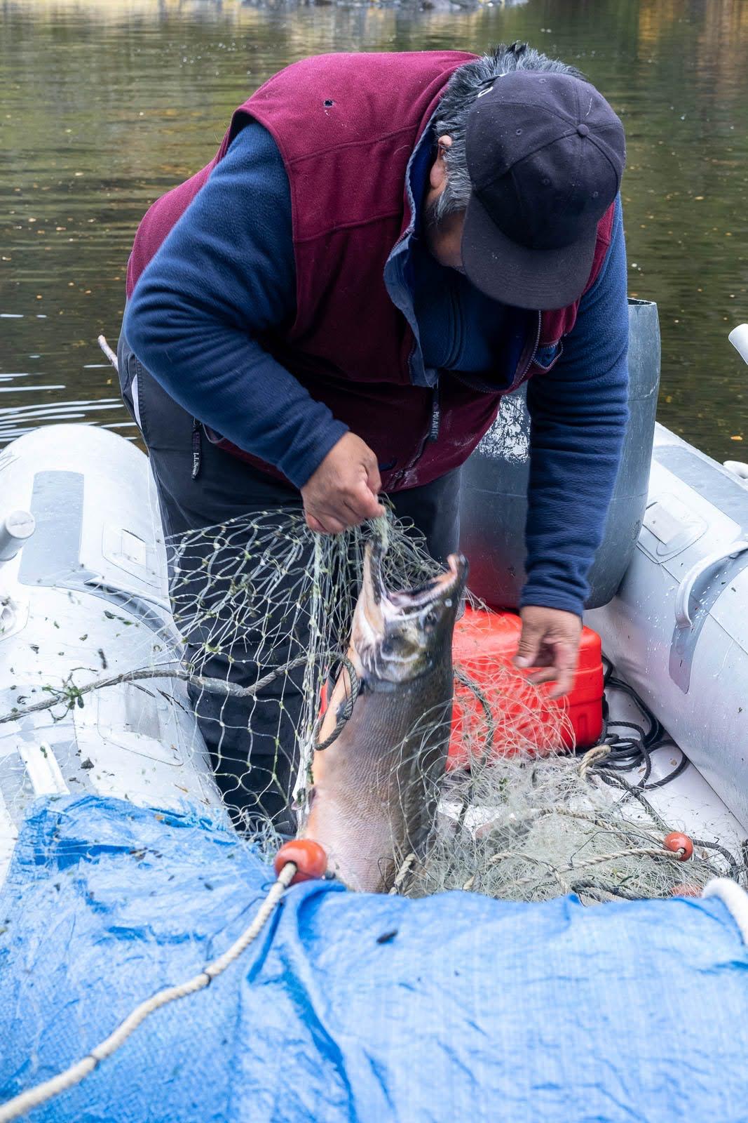
An example of a salmon caught by José near the northern arm of the Beagle Channel during one of our sailing expeditions in 2025 (photo Christine Stein, Karukinka Association
A challenge of international and multicultural preservation and cooperation
Since 2005, in order to preserve this natural marvel, most islands south of the Beagle are part of the Cape Horn Biosphere Reserve, managed by UNESCO, CONAF, and the Chilean Navy. This designation acknowledges the ecosystem's outstanding importance and establishes long-term conservation frameworks.
We believe that preserving Yagan culture and integrating their ancestral knowledge is essential to understanding and protecting this unique ecosystem. Including Yagan traditional ecological knowledge in contemporary environmental management represents an opportunity to develop innovative approaches to conservation. Knowledge of navigation, climate observation, marine resources, and seasonal cycles forms a scientific heritage of great value, complementing modern research methodologies.
Bibliography
Scientific sources
Ferreyra, G. & González, H. “General hydrography of the Beagle Channel, a subantarctic interoceanic passage at the southern tip of South America.” Frontiers in Marine Science, September 30, 2021.
Marine Mammal Protected Areas Task Force. “Beagle Channel to Cape Horn IMMA – Marine Mammal Protected Areas Task Force.” Marine Mammal Habitat, March 18, 2024.
Lodolo, E., Menichetti, M. & Tassone, A. “Shallow architecture of Fuegian Andes lineaments based on marine geophysical data.” Andean Geology, vol. 45, no. 1, 2018.
Institutional publications
Yaghan’s, explorers and settlers.Museo Yaganusi, Government of Chile. PDF document, 2021.
Canal Beagle sin salmoneras.Mar Patagónico, regional declaration, 2024.
The Beagle Channel free from salmon farming.Mar Patagónico, regional statement, 2024.
Phytoplankton biodiversity and water quality in the Beagle Channel, Argentina, 2017–2021.Government of Argentina, PDF document.
Articles
El Rompehielos. “The importance of marine biodiversity in the Beagle Channel.” January 29, 2020.
Radio del Mar. “Beagle Channel is a key research ecosystem for marine biology.” May 22, 2023.
Centro IDEAL. “Scientists unravel the structure of the Beagle Channel.” November 11, 2021.
Audiovisual docs
“Discovery of the Beagle Channel.”YouTube, June 20, 2021.
“The importance of marine biodiversity in the Beagle Channel.”YouTube, January 29, 2020.
Conservation organizations
Rewilding Chile. “Beagle Channel: exploring the end of the world.” September 3, 2023.
Rewilding Chile. “Canal Beagle: explorando el confín del mundo.” September 3, 2023.
Table of content : sailing patagonian channels part 1
Tuesday, January 28, 2025: Departure of the sailing expedition in the Chilean Patagonian Channels
A tough wake-up this morning; the night was short and the previous day was busy, as always before an 18-day sailing expedition in the Cap Horn biosphere reserve, the southern Chilean fjords : provisioning, supply runs… a host of things that, of course, can only be done last minute in Ushuaia!
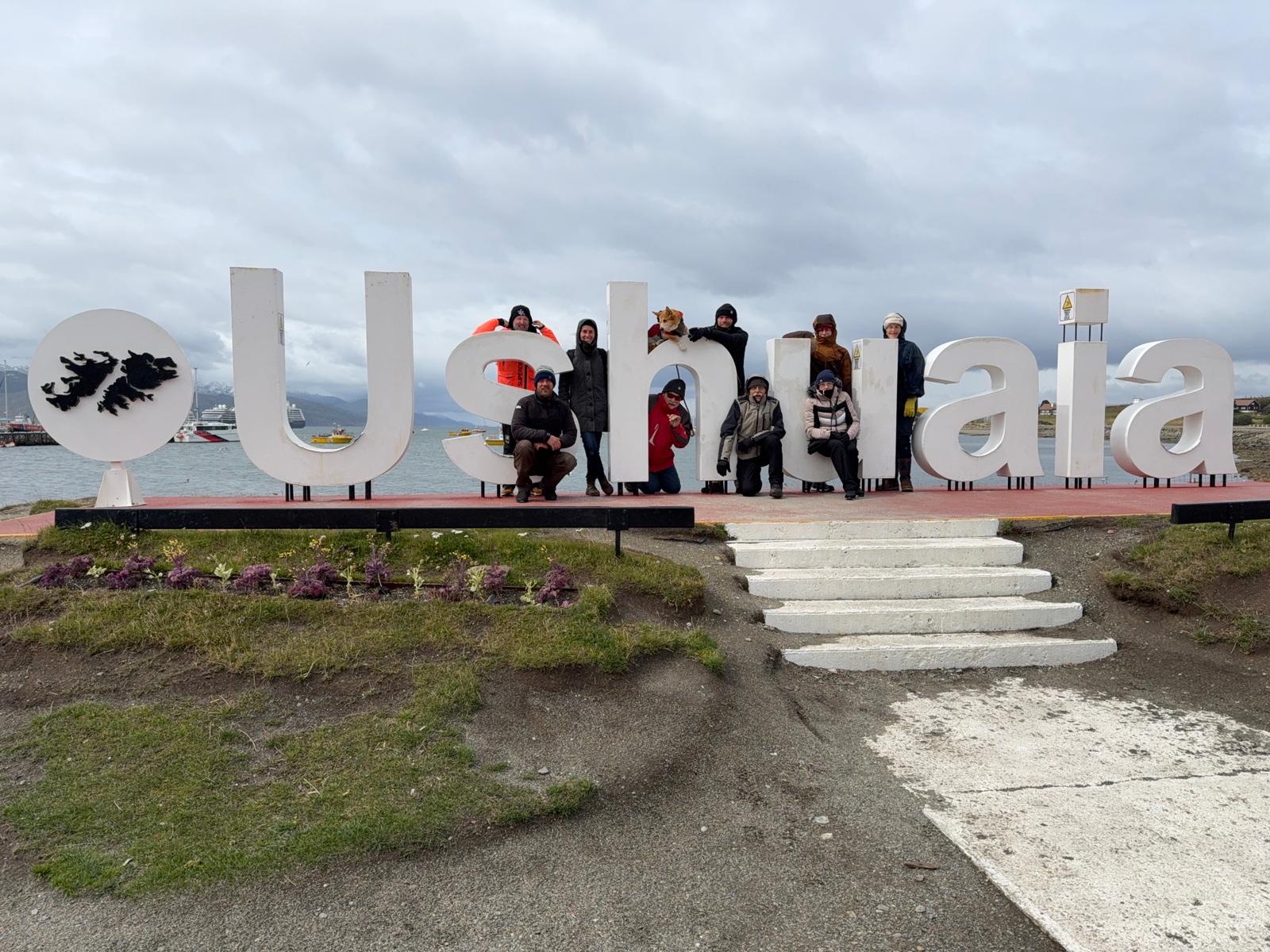
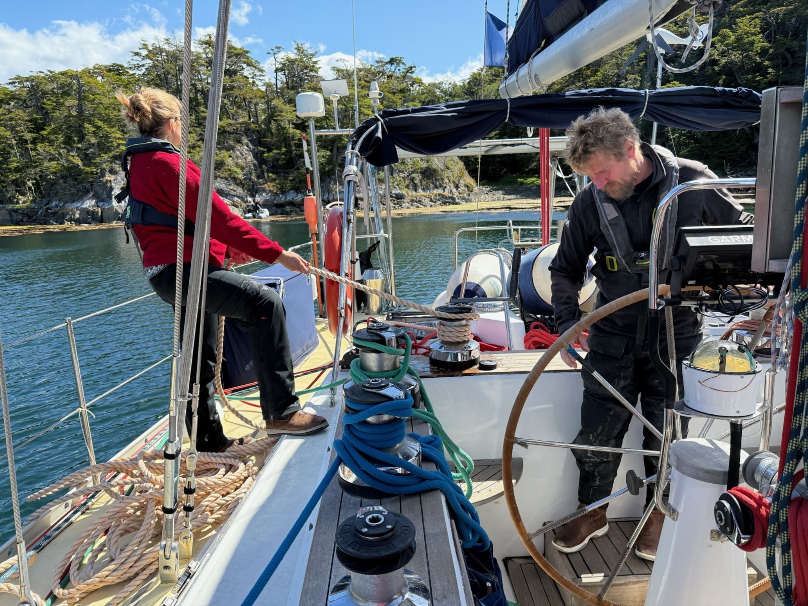
The crew of Milagro, association Karukinka, in Ushuaia (Photo Pascal Madert)
So, 8 a.m., breakfast, and quite a crowd for this breakfast. Yesterday, we welcomed 5 new crewmates: Annick and Jacques, the Gers natives aboard, Pascal from Grenoble, Alain from Vannes, and Françoise from Paris; their common point: they’re all happy retirees! With Aude, who simply refuses to leave the boat, Damien, Lauriane, and myself, that makes 9 crew members!
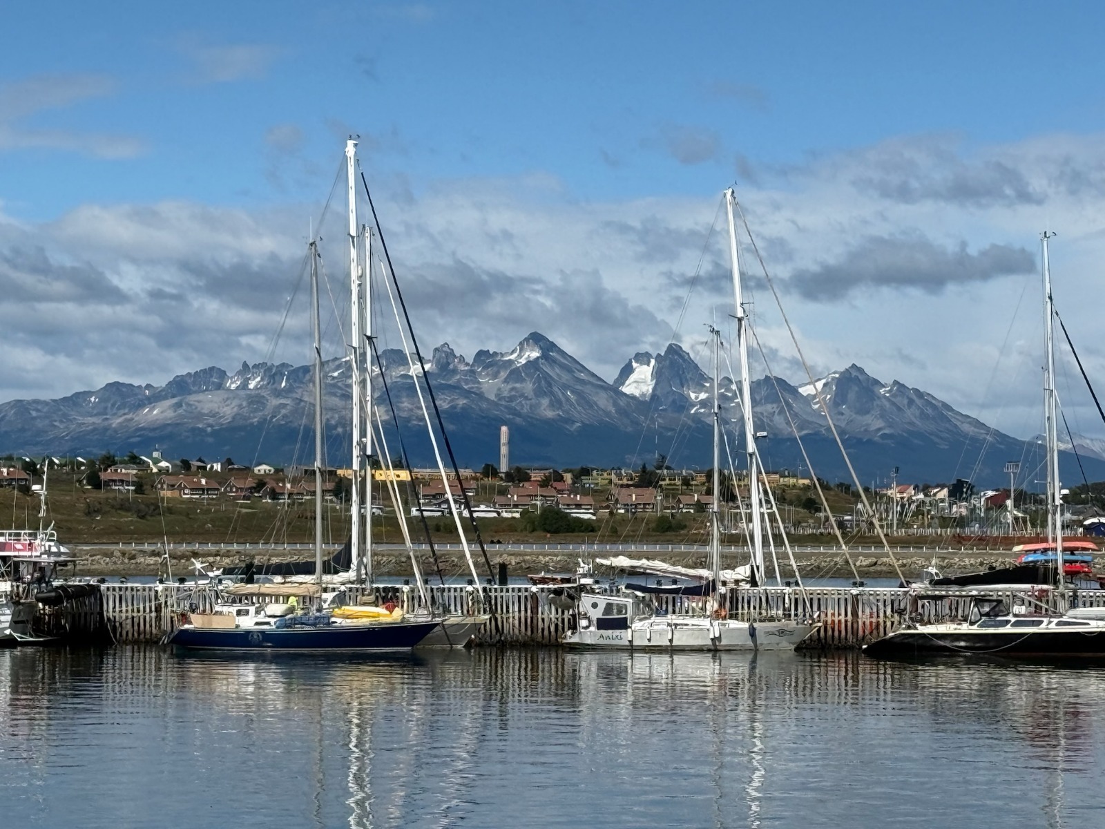
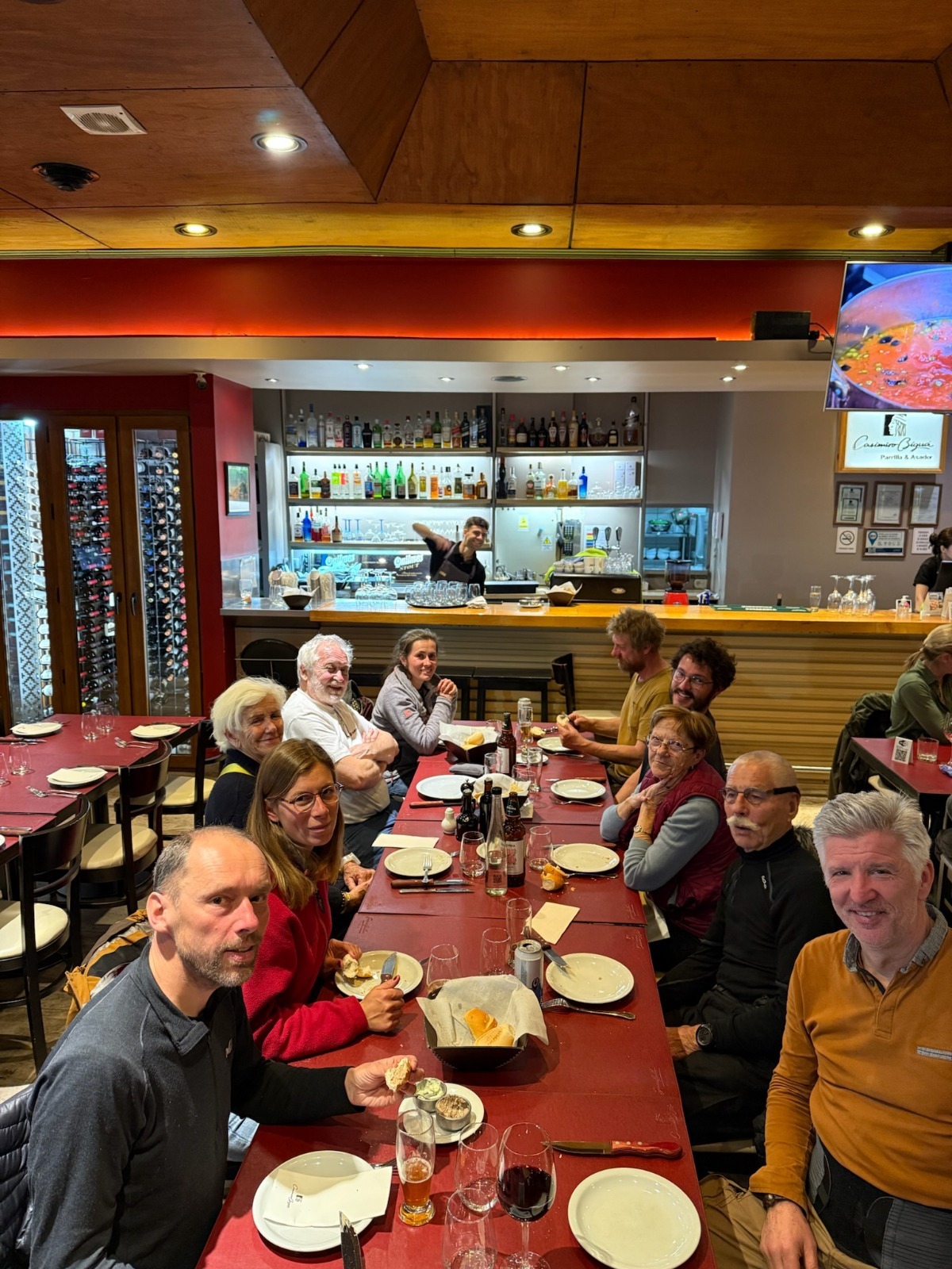
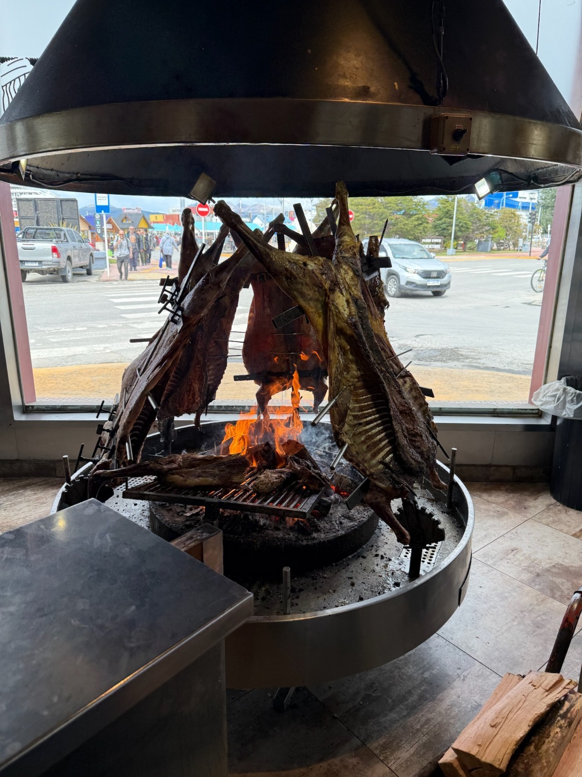
Sailiboats at the pontoon in Ushuaia Nautical club (P. Madert)Departure dinner ! (P. Madert)The traditional fuegian asado (lamb) (P. Madert)
Once everyone is settled, the ritual begins: completing formalities with the local authorities in Ushuaia. For every trip, you have to visit the naval prefecture, immigration, and customs, both on the Argentinian and Chilean side! After this, we get a standard inspection, as often happens, such as at Bahia San Blas during our offshore cruise along the Argentinian Patagonia from Buenos Aires. Usually, it’s mainly a check of the boat’s papers, communication, and safety equipment… and it always goes smoothly!
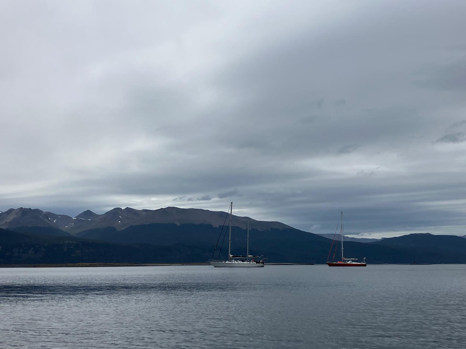
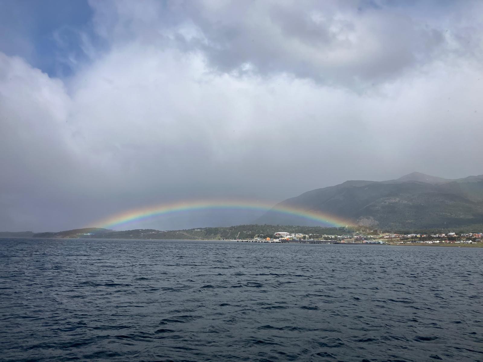
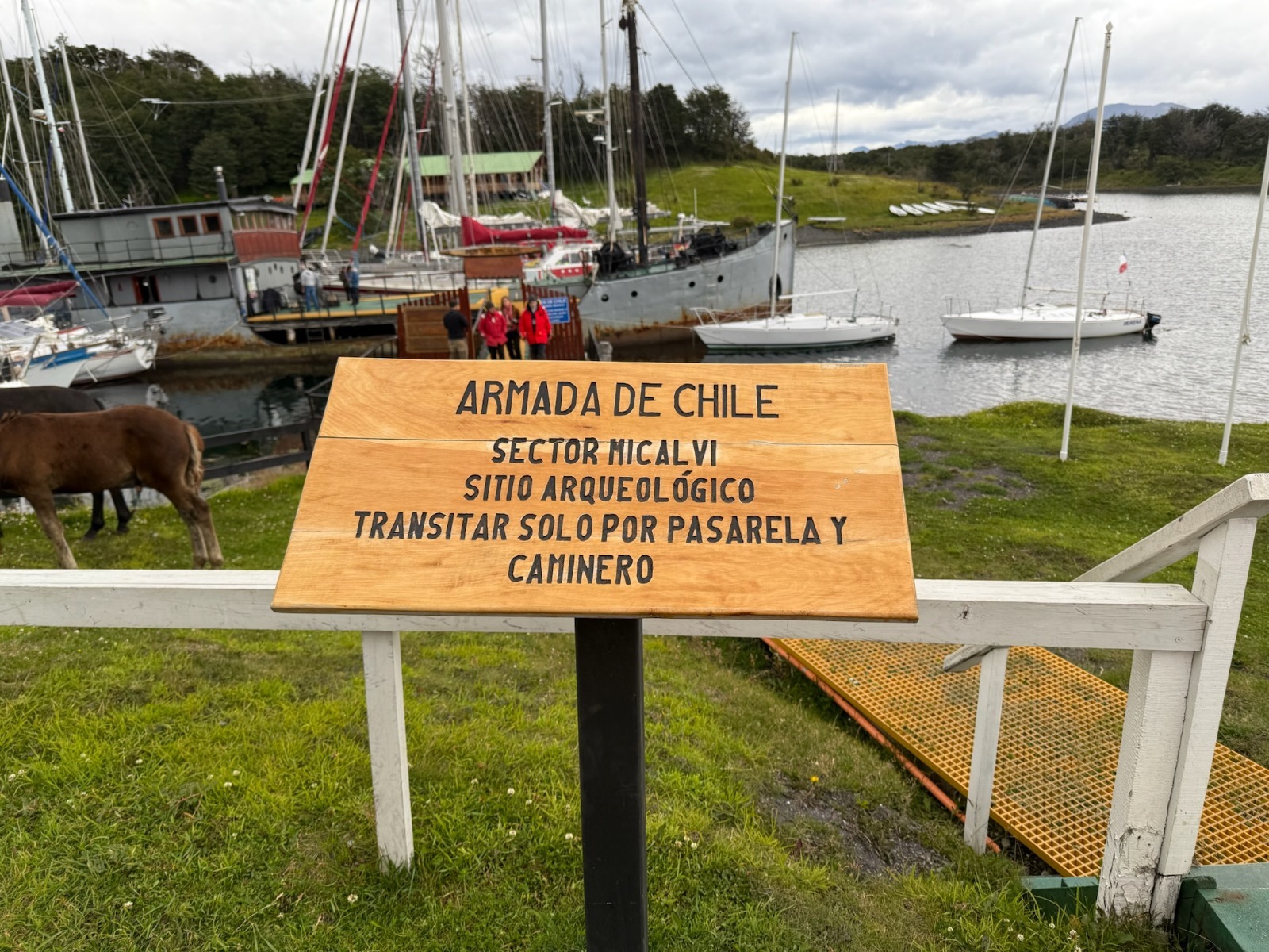
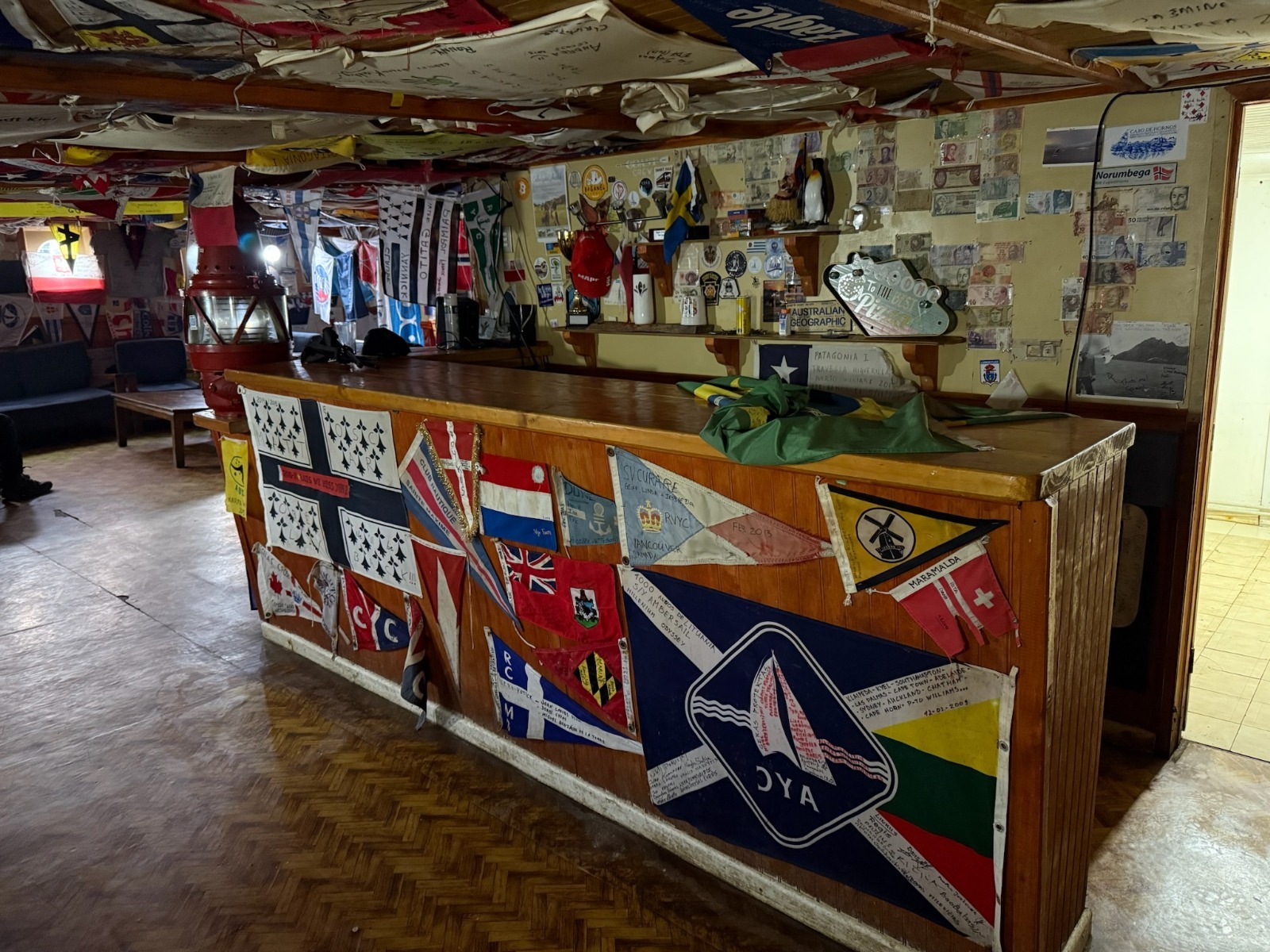
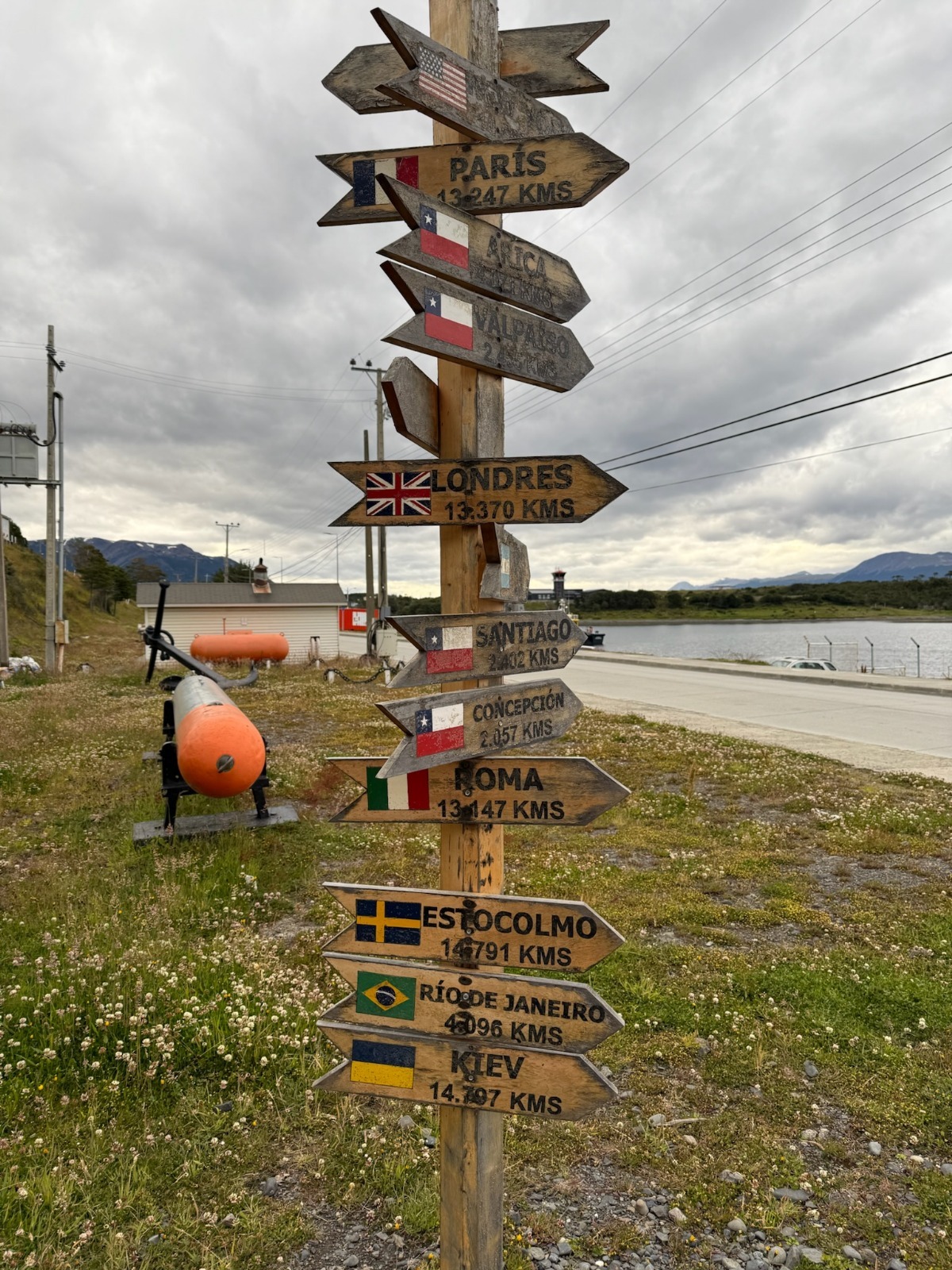
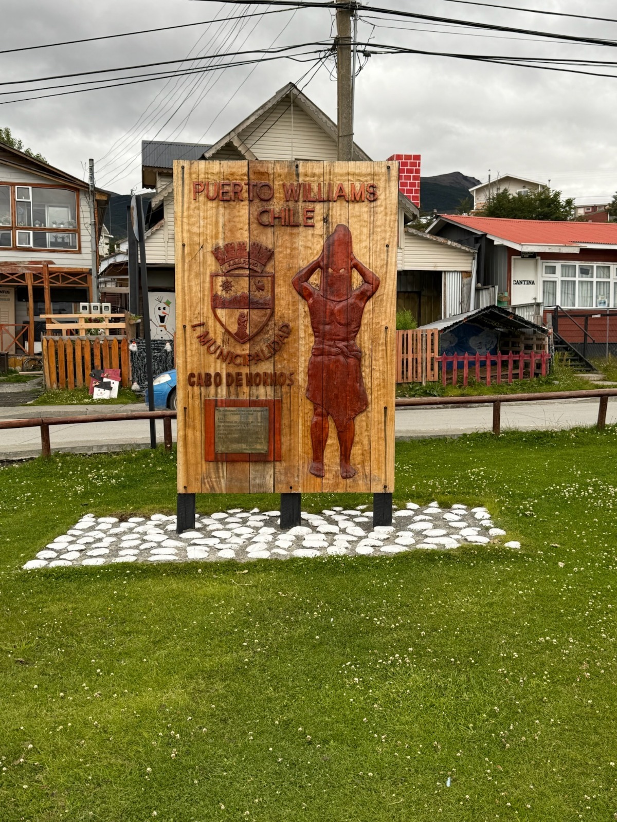
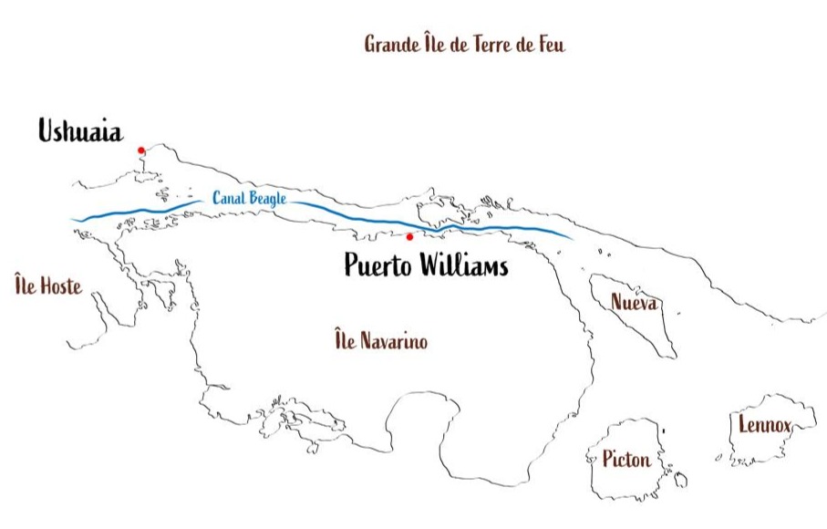
With all these requirements, we don’t leave Ushuaia until 1 p.m., arriving at Puerto Williams, the southernmost city in the world, on Navarino Island (province of Cape Horn and Chilean Antarctic), after a smooth crossing. We anchor in front of the city, as there is no space at the fishing port, and near the famous Micalvi, the pontoon-boat and historic local heritage known to sailors passing through before heading further south. A bit later, another French sailboat, which has been in the region a long time, anchors next to us: the Podorange.
The sailing yachts Milagro and Podorange anchoring in Puerto Williams bay (Cabo de Hornos, Chili)Rainbow over the city of Puerto WilliamsThe Micalvi marina (P. Madert)The inside of the Micalvi, several tens of sailing expeditions represented (P. Madert)The end of the world ! (P. Madert)Puerto Williams, city of the Cape Horn and Chilean Antarctic region (P. Madert)
Wednesday, January 29, 2025: Awaiting formalities → hiking on Navarino Island!
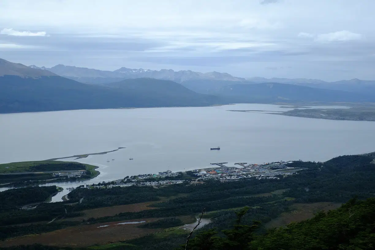
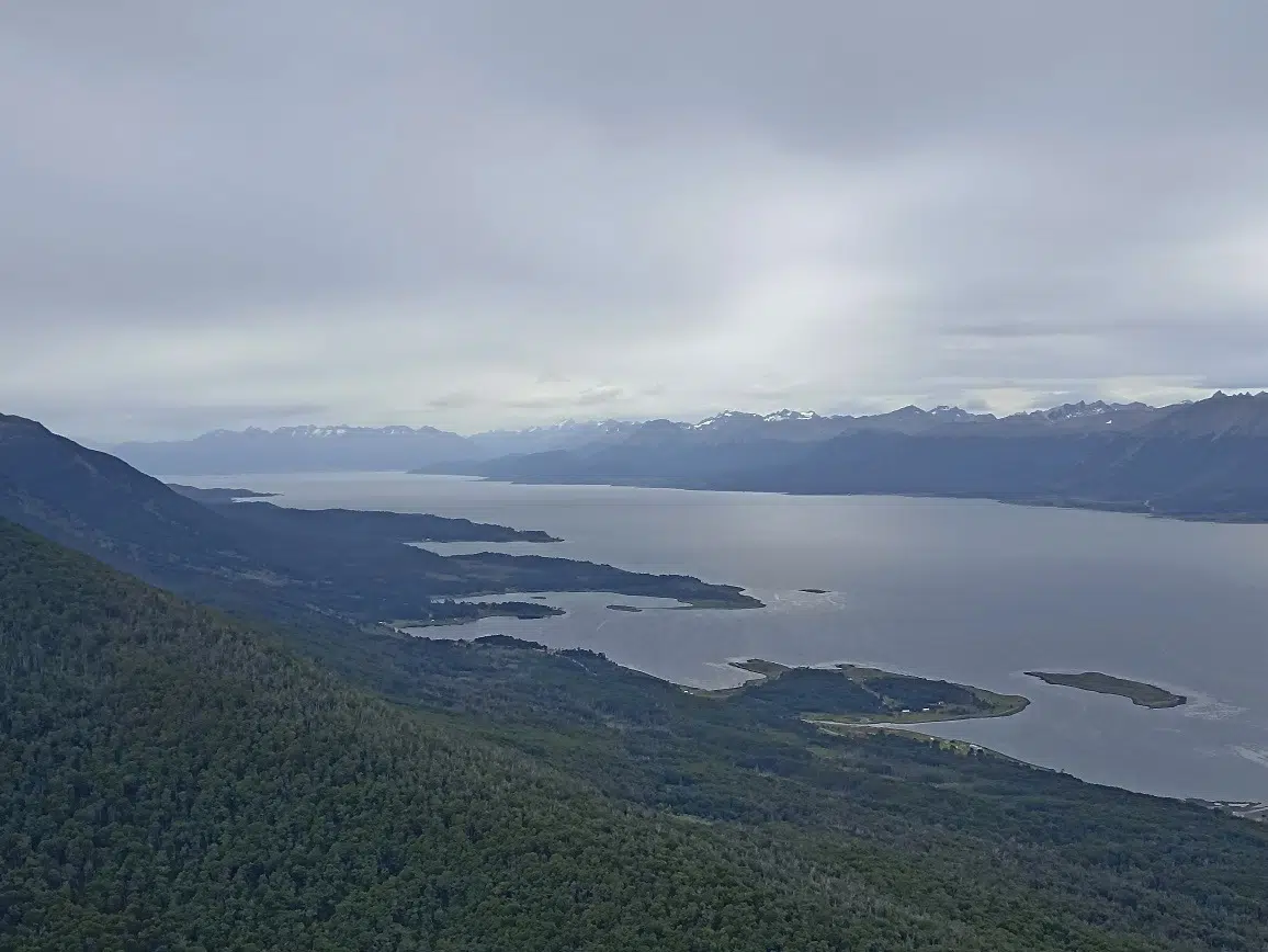
This morning, and since we’re in Chile, it’s back to entry formalities with the various authorities. So, a day on land for everyone: Lauriane and Damien tackle the paperwork marathon, Alain and Annick go for a walk along the Beagle Channel shore, and Pascal, Françoise, Jacques, Aude, and I set out to climb the “school” summit above the village: Cerro Bandera. This 600m peak offers a panoramic view of the surroundings.
Access to this summit is an exception in the region: it’s one of the few with a well-maintained, marked trail, making the climb easy. Most of the time elsewhere, you have to find your own way – nature is everywhere and only reveals itself after real effort!
It’s a beautiful ascent, pleasant after leaving a 4x4 track: we cross remarkable Fuegian forest, then low, dense shrubs battered by winds, before reaching the bare mineral zone, where only moss survives – nearing the summit. The sky is overcast but calm, and visibility excellent. From various points, you admire, at different elevations, the channel and surrounding peaks…
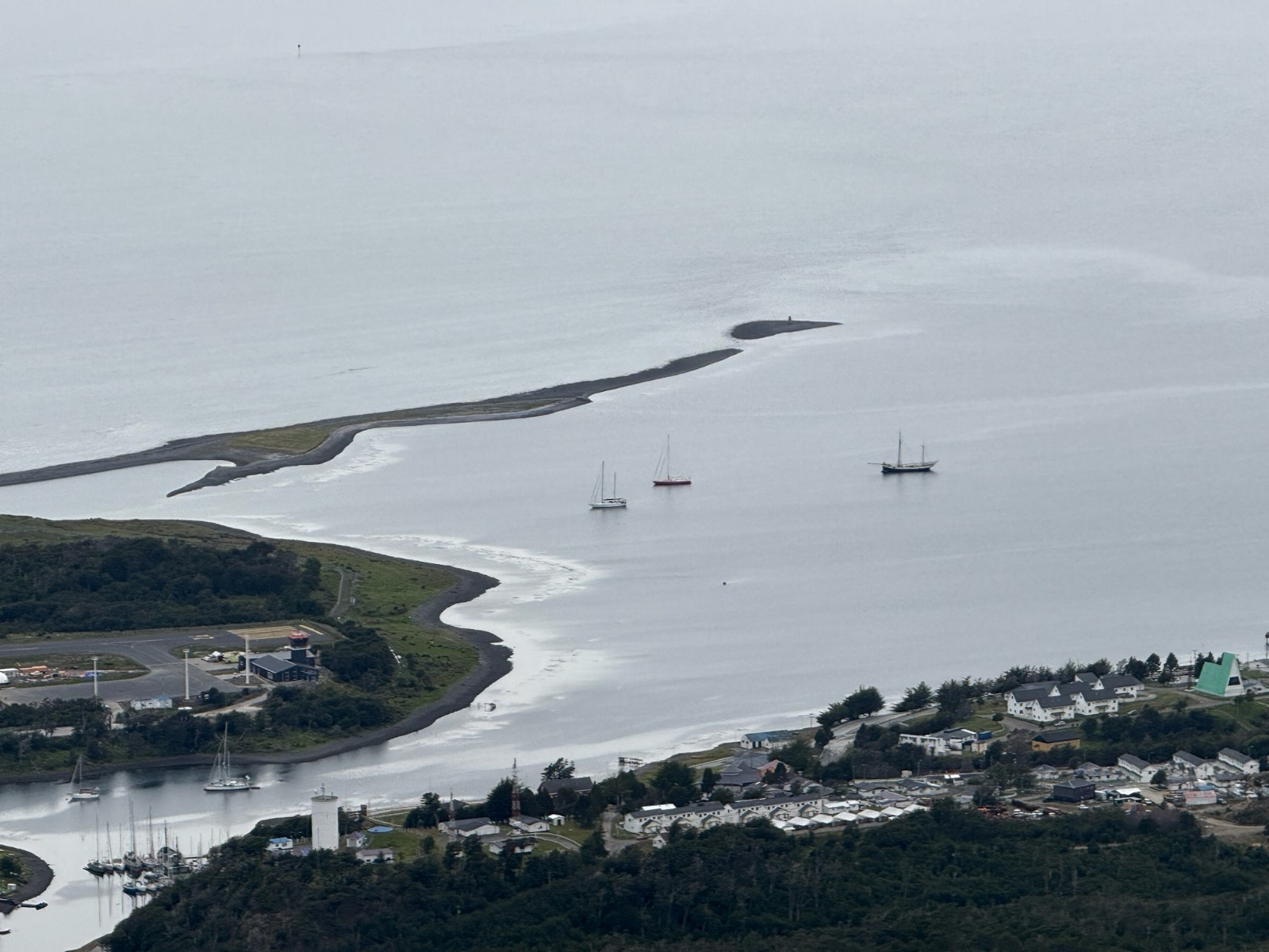
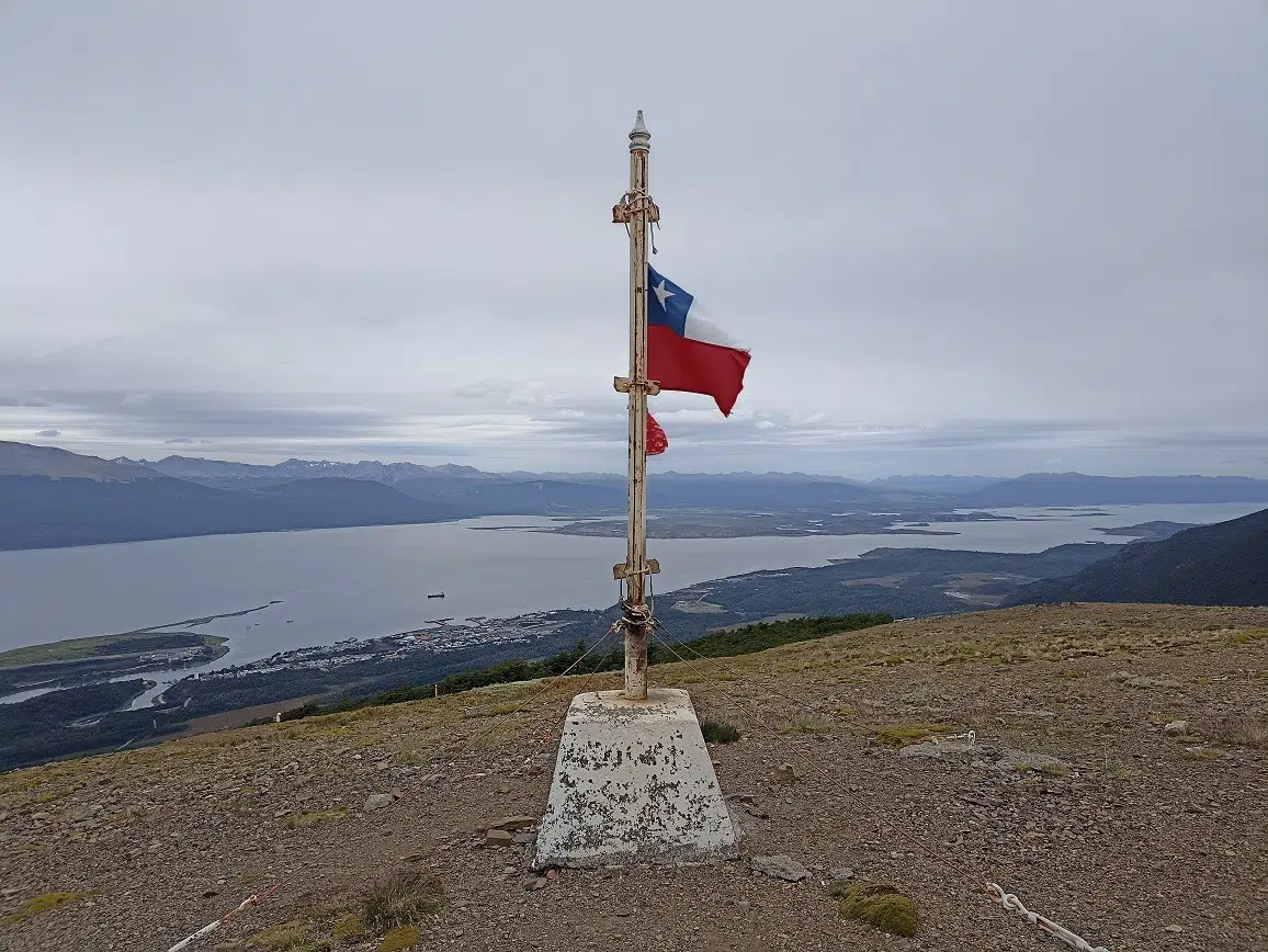
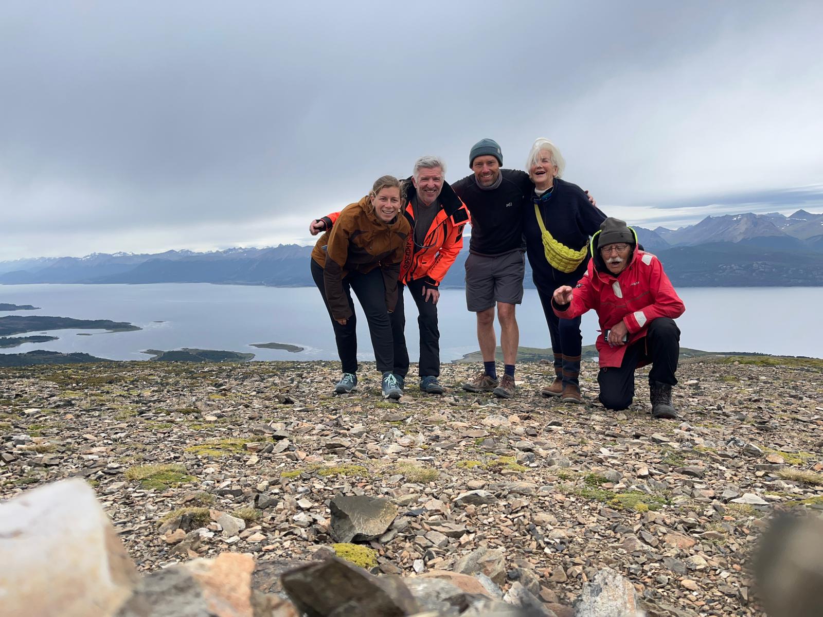
View of Puerto WilliamsIn the middle, on the left side : our Milagro ! (P. Madert)The Onashaga (Beagle channel) separating Navarino island and Tierra del Fuego islandThe summit of the cerro BanderaPart of the crew at the summit of Cerro Bandera (Navarino island, Chile) Photo Aude Grillault-LarocheThe flora on the summit of cerro Bandera (P. Madert)
Everyone climbs at their own pace and meets at the top, marked by a cairn capped with a Chilean flag. From the summit, you see various trails suggesting many multi-day hikes to explore this island; it’s quite stirring…!
The kind weather means we have a picnic and a restorative nap, before heading back down the same way, ending up in a cozy tea room. Back on board by 6:30 p.m. for a quiet evening after a great walk.
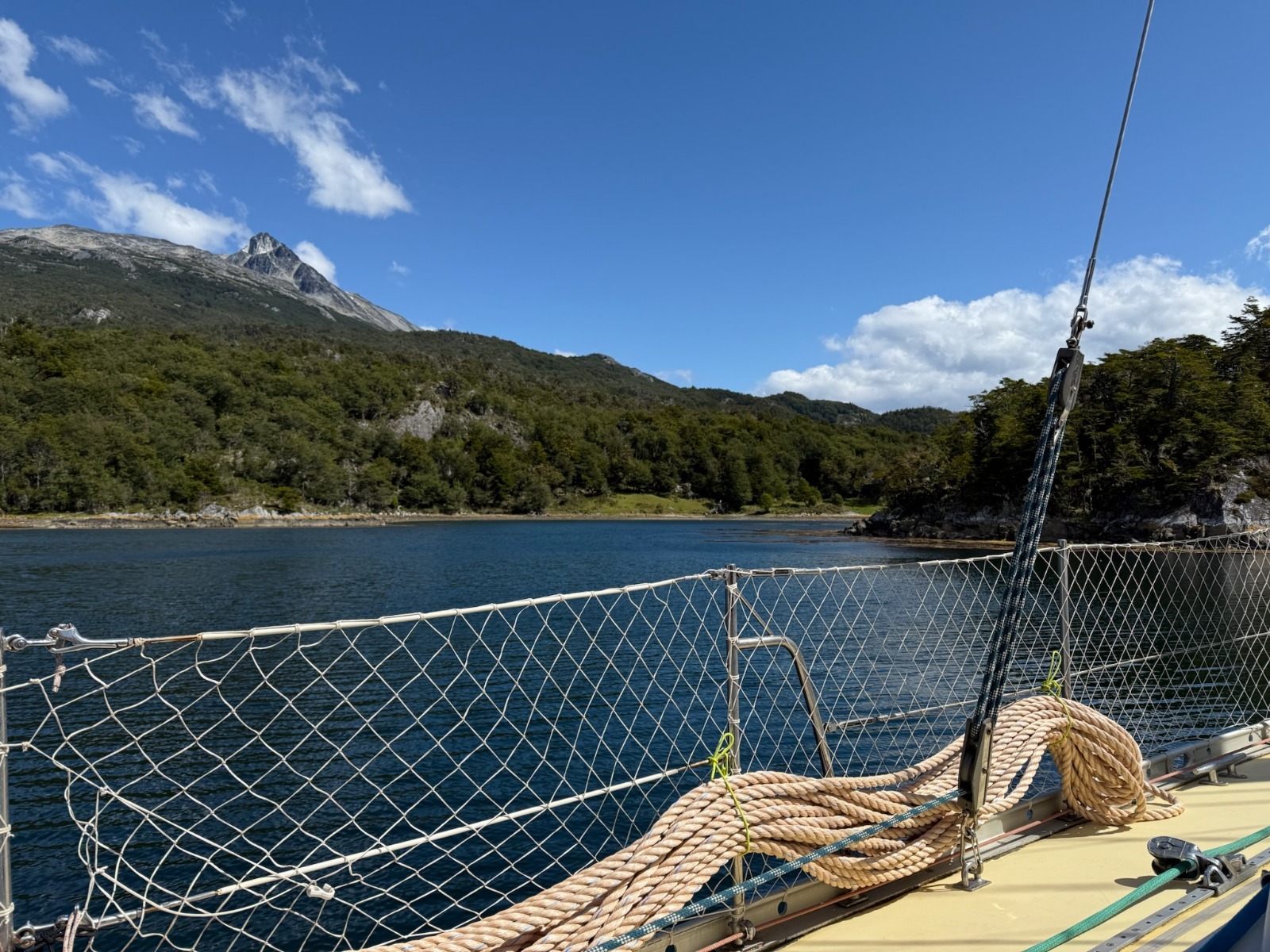
Thursday, January 30, 2025: heading west in the Beagle channel, toward Hoste island
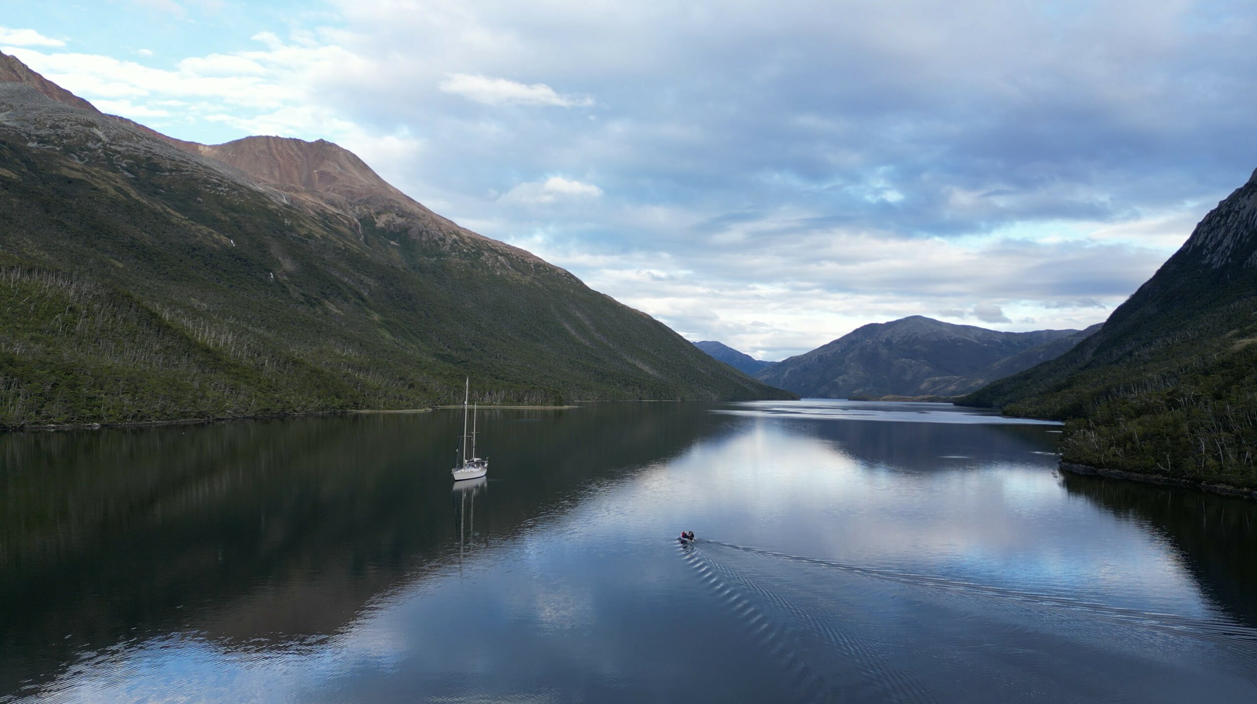
Up at 6 a.m., departing at 7 a.m., we have a long way to go: we head west again, pass Ushuaia and continue to Hoste Island. Sailing is calm, motoring for lack of wind. In early afternoon comes a surprise: the wind picks up, stormy, gusts up to 45 knots, the Beagle Channel reveals its bad-weather face, and it’s impressive. Only one sensible solution instead of motoring head-on: take cover.
We head for Caleta Letier (Dumas Peninsula, Hoste Island, Chilean fjords). The place is beautiful, a small, well-protected bay with forest trailing right to the shore. Anchoring, though, is less idyllic… The anchor doesn’t catch – so much kelp on the bottom that it’s impossible; it comes up covered with mountains of kelp and a bit of mud. Everything has to be cut away before trying again—exhausting and messy!! Finally, success: Milagro is secure at anchor! Phew!!
Some lines on land to secure the anchoring in the caleta (P. Madert)et on reprend le mou à bord, sans laisser la tension sur le winch en fin de manoeuvre ! (P. Madert)
Good thing too, because the unforecast storm is fierce: gusts at 40 knots, strong and sudden, tip Milagro on its side, sheltering in the bay. In the channel it’s worse: gusts top 50 knots, the water turns white, wave crests are blown into a whiteout over the sea. The Chilean Navy bans navigation for now, and Ushuaia and Puerto Williams ports close.
Anchorage in the caleta Letier (Hoste island, Cape Horn and Chilean Antarctica province, 30/01/2025)
The place is harsh but gorgeous: coves, forest, and mountains everywhere….
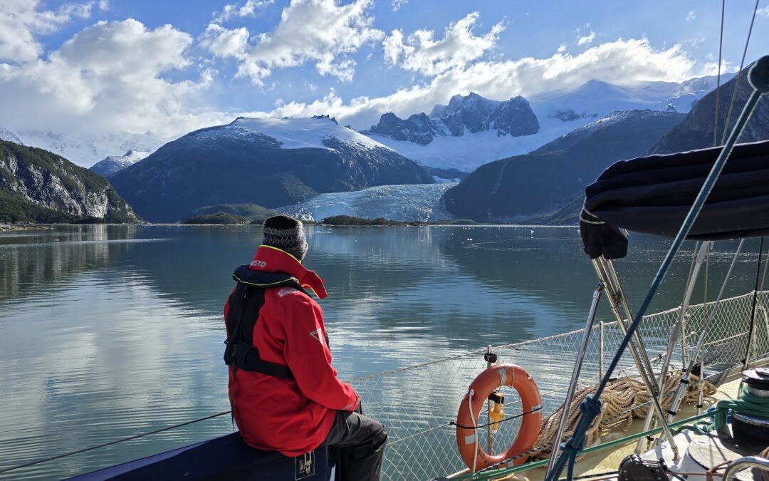
Friday, January 31, 2025: First glimpse of the Darwin Cordillera glaciers and anchoring in a bay on Gordon Island
8 a.m.: a morning stroll on deck – magnificent! The wind is down, even the channel is calm. A delicious moment of peace, alone at the end of the caleta.
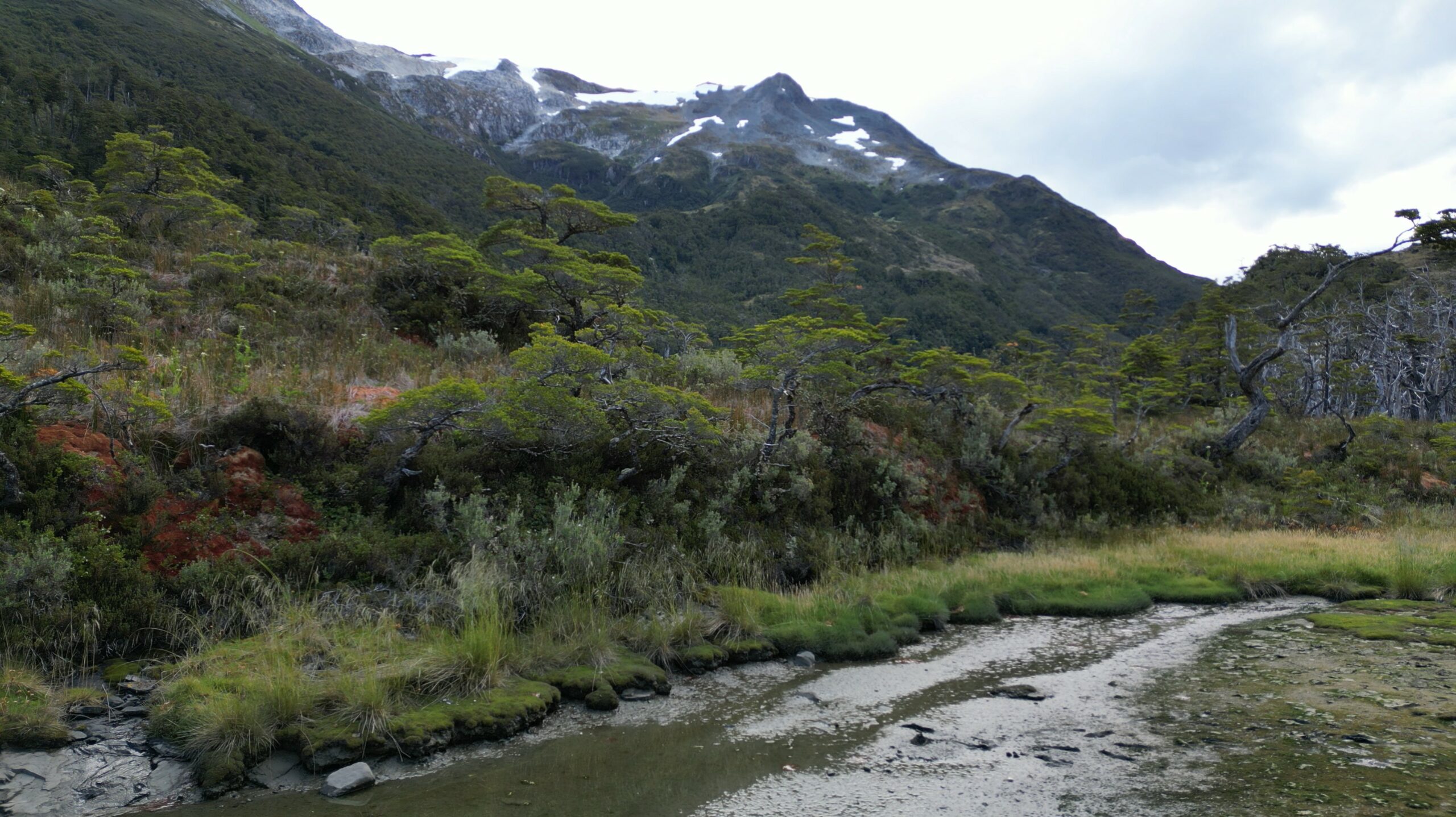
We head west, Hoste Island to port, Tierra del Fuego to starboard, and in the distance, Darwin Range glaciers sparkle in the sun. The scenery is breathtaking – channels bordered by dense Fuegian subantarctic forest, mountains, and glacier-topped peaks. It’s extraordinary to be in one of the last places on Earth where nature reigns and humans are nearly absent.
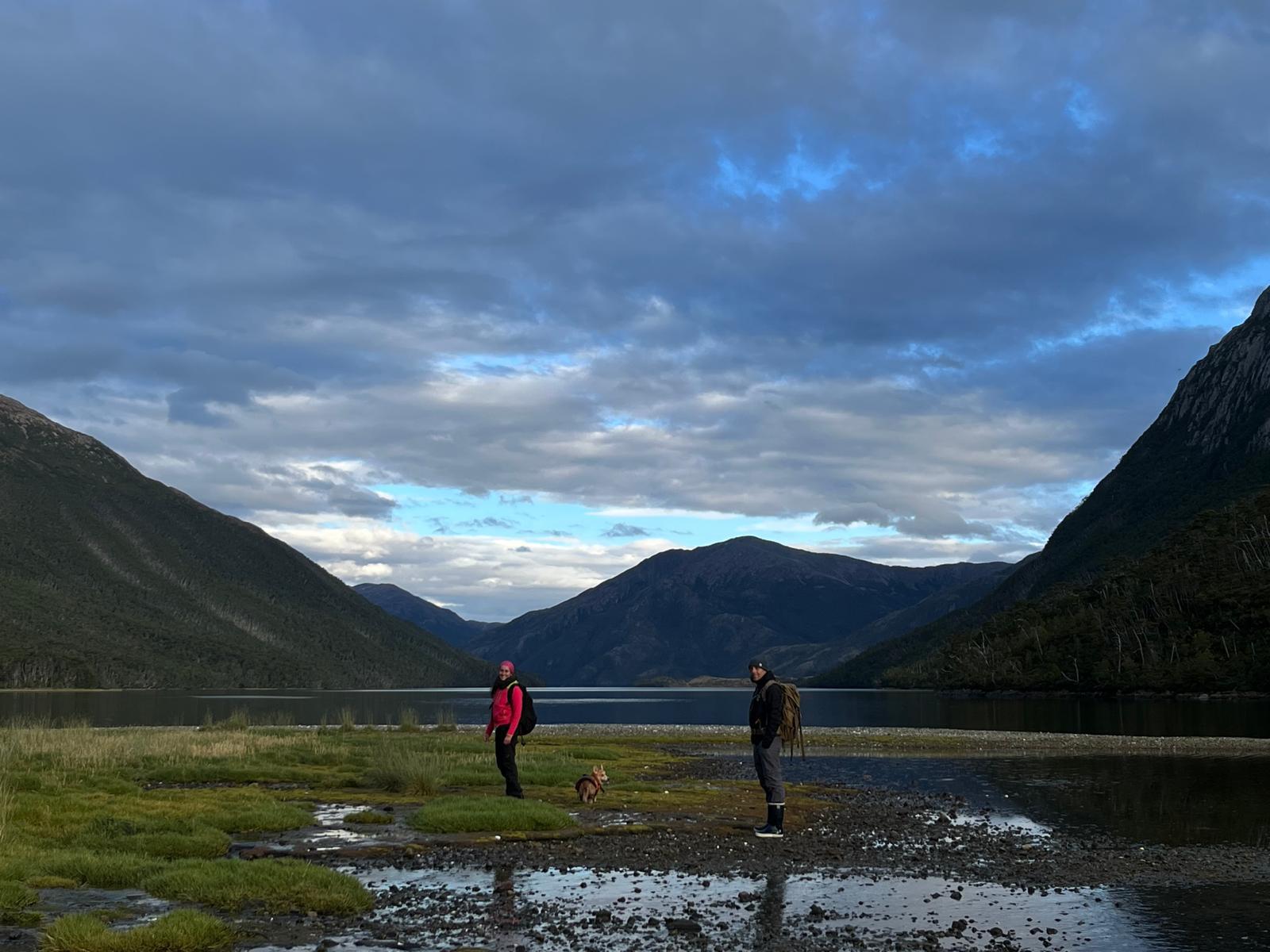
We enter the southern arm of the channel; Hoste Island remains to port, and now, to starboard, the Gordon Island coast follows Tierra del Fuego. We pass tall glaciers, hugely diminished by climate change: like the mountains, polar zones are most affected…. We turn into an unmapped fjord and follow it up several km to anchor at its end, beneath a waterfall and a stream from a melting glacier. The glacier towers above, fresh and grand: we are in Caleta Eva Luna. The place is sublime, and the joy on Lauriane’s face – who recorded sounds and took photos here in 2018 – says it all.
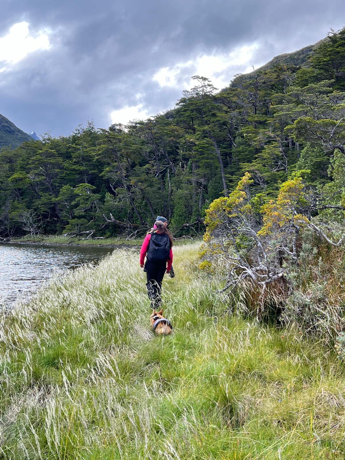
Walking in Eva Luna bay (Gordon island, Chile, 2025)Walk in Eva Luna Bay (Biosphere Reserve of Cape Horn, Chile, 2025)The subantarctic fuegian forest in Eva Luna bay (january 2025)And to see the same place in the middle of autumn photographed by Lauriane (mid-May 2018)
A short walk along the shore takes me back years too: the dense, impenetrable Fuegian forest, the waterlogged boggy ground, all as I remember. Toupie, our faithful four-legged mascot, delights in playing fetch with abundant sticks on the shore!
The sailing yacht Milagro anchored in Caleta Eva Luna, Gordon island, province of cape Horn and Chilean Antarctica, January 2025
It’s a quiet night; we rest up to keep going west tomorrow… To be continued in the next post ;-)
Karukinka, a non profit organization in Patagonia, invites you to write the next chapters of this unique epic — where maps still read “unmapped.” Joining Karukinka is more than joining an association: it’s embarking on an exceptional human and maritime adventure, reconciling modern exploration with ancestral memory.
Our association now gathers a hundred members of 12 different nationalities, united by a passion for extreme lands and a strong commitment to Indigenous cultural preservation. Whether you are an experienced sailor, scientist, artist, or simply fascinated by wide spaces and just causes, Karukinka offers the unique chance to join sailing expeditions and a cartographic exploration project that will make history.


![[Sailing Patagonian channels] Sébastien’s Logbook part 1](https://karukinka.eu/wp-content/uploads/2025/08/Caleta-eva-luna_012025_Karukinka4-1080x675.jpg)