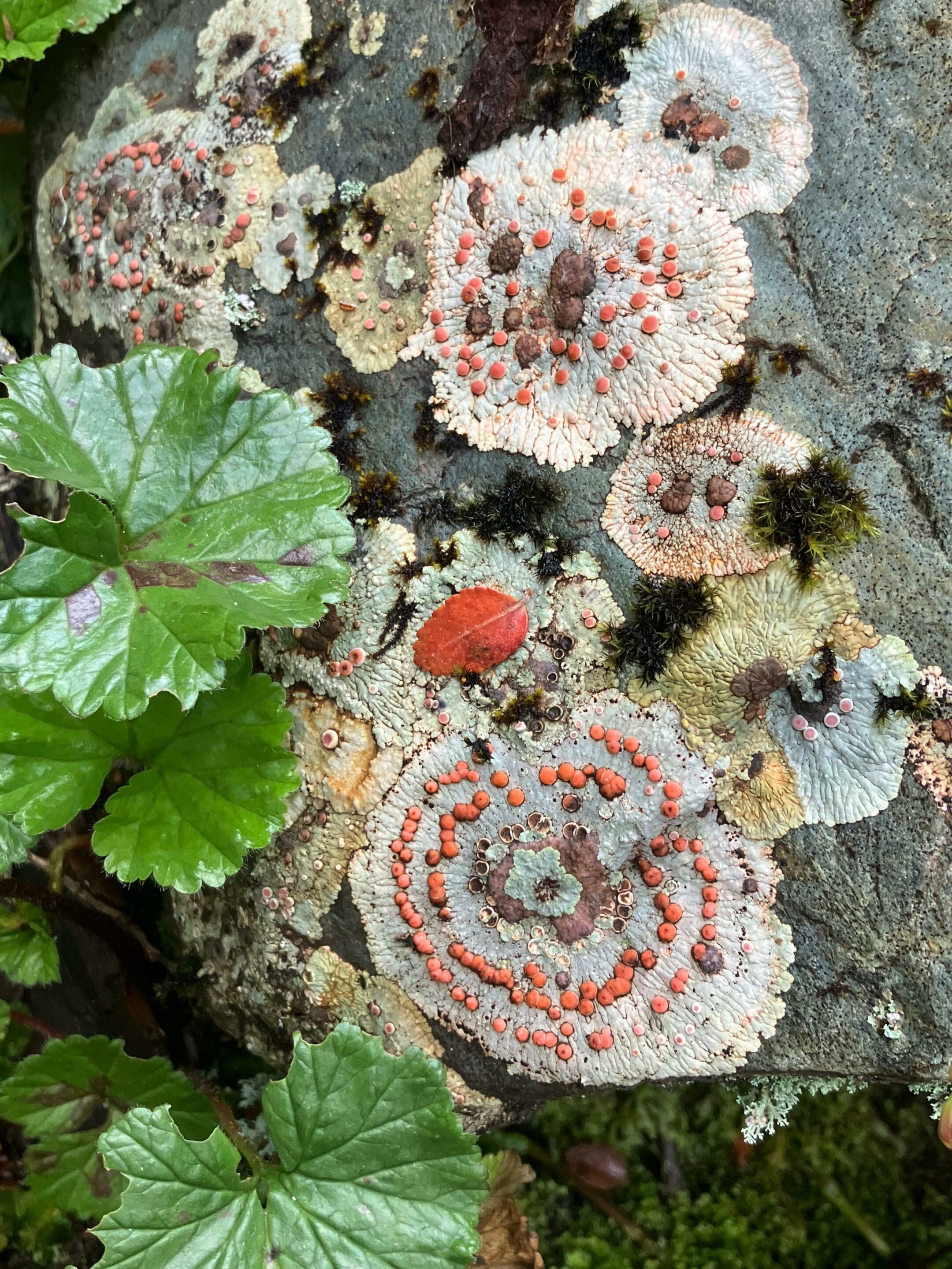
The yellow powder that Puerto Williams residents have always seen on the trunks of lenga beech (Nothofagus pumilio) had never received a scientific name: Candelariella magellanica. In January–February 2005, and again in January 2008, an international team of lichenologists conducted the first intensive floristic survey of the lichen flora of Navarino Island in the Cape Horn Biosphere Reserve. The result: 416 taxa recorded — and two species proposed as new to science.
Editorial note: This article draws directly on the open-access PDF of the reference publication: Etayo et al. (2021), Catalogue of lichens (and some related fungi) of Navarino Island, Cape Horn Biosphere Reserve, Chile, Anales del Instituto de la Patagonia, 49. DOI: 10.22352/AIP202149013. The article is freely available on the Cape Horn International Center website.
Table of content
The first intensive inventory of Navarino
For decades, Navarino was the poor relation of subantarctic lichenology. The Swedish botanist Rolf Santesson had made the first collection in 1940 along the northern coasts of Hoste and Navarino islands, but his specimens were never published during his lifetime. In 1977, Redón and Quilhot listed 56 species for the island. By 2008, Etayo and Sancho had raised this count to 113 through work on lichenicolous fungi. The 2021 catalogue multiplied that total in a single publication to 416 taxa, thanks to two field campaigns during the southern summers of 2005 and 2008, covering 46 sites across all major habitat types on the northern and northwestern part of the island — evergreen forests, deciduous forests, Magellanic moorlands, high-Andean habitats, coasts, and lakes.
This richness places Navarino Island (2,514 km²) above the Falkland Islands (more than 12,000 km²) in terms of recorded lichen taxa: the Falklands, lacking native trees and subject to a more extreme climate, count only around 353 species. The reason is structural: the southern beech (Nothofagus) forests of Navarino offer a diversity of substrates — bark, dead wood, stumps, mosses, rocks, soils — and constant humidity that enables an exceptionally dense epiphytic community to establish: a single trunk can host more than a hundred species of lichens and bryophytes.
The seven lichen habitats of Navarino
The study described seven major habitat types supporting lichen communities on Navarino Island:
This vertical and lateral gradient makes Navarino Island a particularly suitable space for studying the adaptation of lichens to subantarctic constraints: permanent winds, frequent freeze-thaw cycles, and precipitation ranging from 500 to over 1,000 mm depending on slope aspect.
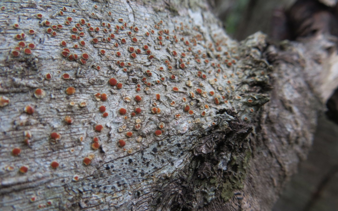
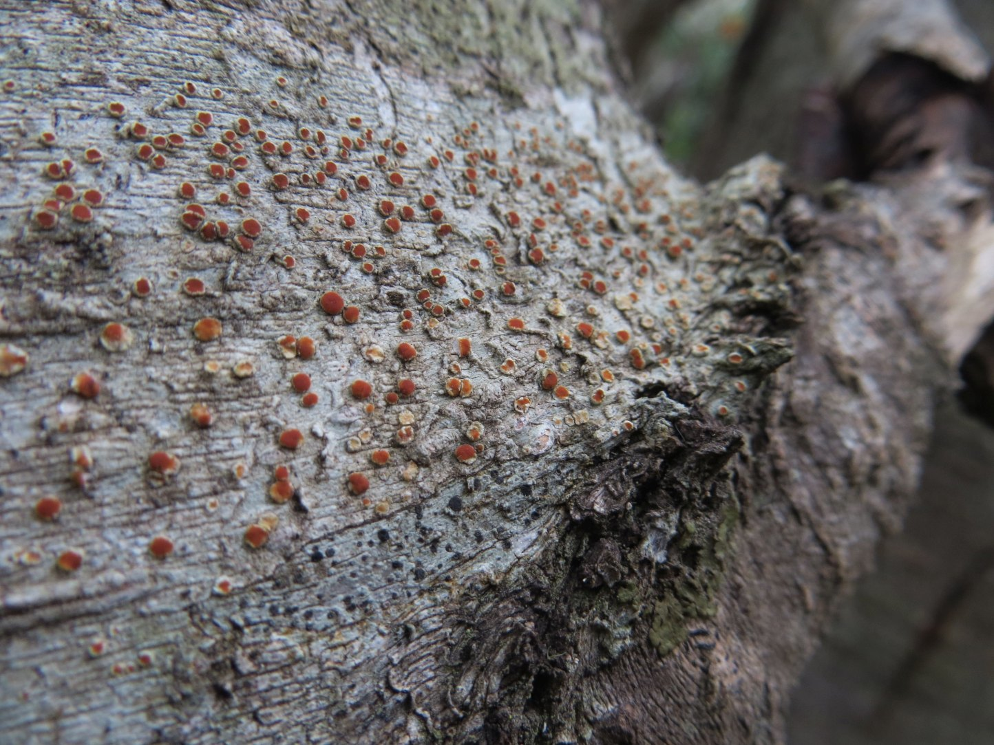
Candelariella magellanica: description of the new species
Candelariella magellanica Etayo sp. nov. is a sulphur-yellow corticicolous lichen producing powdery propagules known as soredia, rather than conventional fruiting bodies. It colonises the bark of old Nothofagus pumilio in the deciduous forests of Navarino, at altitudes ranging from 86 to 560 metres. The formal description distinguishes it from the closest related species, Candelariella xanthostigmoides, by larger-diameter apothecia and spores frequently divided into two cells.
To the naked eye, C. magellanica appears as a thin layer of yellow powder on bark — virtually invisible without a hand lens. Yet it is present on numerous trunks in N. pumilio forests across the island, as observations along the Cerro Bandera, Cerro Ukika, and Lago Róbalo trails confirmed. It is precisely this visual inconspicuousness that explains why this locally frequent species remained unknown to science until 2021.
Sclerococcum nothofagi: an undescribed saprobic fungus
The second new species described in the catalogue is a saprobic fungus — not a lichen but a fungus associated with lichens — named Sclerococcum nothofagi Etayo sp. nov. It grows on the thick, aged bark of Nothofagus pumilio, alongside corticicolous lichen species. Its muriform spores (forming a network of cells) distinguish it from all known species in the genus. Its name directly references its exclusive substrate: the bark of southern beeches of the genus Nothofagus.
Alongside these two new species, Tremella haematommatis Diederich was recorded for the first time in South America, parasitising Haematomma nothofagi — itself a lichen endemic to Nothofagus forests.
The 2021 catalogue demonstrated that the Cape Horn Biosphere Reserve is not only a global hotspot of bryophyte diversity — already established by the Omora Park team's earlier work — but also a first-order lichen hotspot for the Southern Hemisphere. The authors note that only the northern and northwestern half of the island was covered during both campaigns; the southern section, logistically difficult to access, remains to be surveyed and likely holds further discoveries.
The ecotourism with a hand lens developed at Omora Park now guides visitors towards these barely visible yellow coatings on lenga trunks, revealing to them that they are looking at a species known nowhere else on Earth — an invitation to shift perceptual scale in one of the remotest places on the planet.
Bibliography
Etayo J., Sancho L.G., Gómez-Bolea A., Søchting U., Aguirre F. & Rozzi R. (2021). Catalogue of lichens (and some related fungi) of Navarino Island, Cape Horn Biosphere Reserve, Chile. Anales del Instituto de la Patagonia, 49. https://doi.org/10.22352/AIP202149013
Etayo J. & Sancho L.G. (2008). Lichenicolous fungi from the Southern Hemisphere. II. Some new species and records from South Shetland Islands, South Georgia Island and Tierra del Fuego. Nova Hedwigia, 86 : 135–172.
Goffinet B., Rozzi R., Massardo F., Buck W. & Leiva M. (2012). Miniature Forests of Cape Horn: Ecotourism with a Hand Lens. University of North Texas Press.
Redón J. & Quilhot W. (1977). Líquenes del archipiélago del Cabo de Hornos. Boletín del Museo Nacional de Historia Natural de Chile, 35 : 53–71.
Rozzi R. et al. (2008). Changing lenses to assess biodiversity: patterns of species richness in sub-Antarctic plants and implications for global conservation. Frontiers in Ecology and the Environment, 6(3) : 131–137.
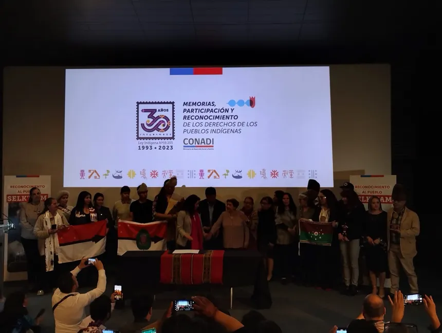
In 2023, Chile officially incorporated the Selk'nam people into Indigenous Law 19.253, nearly a century after the waves of mass violence that swept across Tierra del Fuego. Behind this legal reform lies a long process of memory work, advocacy, and cultural self-affirmation led by Selk'nam families themselves.
Table of content
A people long absent from indigenous law in Chile
Since 1993, Law 19.253 has recognised a list of "indigenous peoples or ethnicities" in Chile and established CONADI, the National Corporation for Indigenous Development. For thirty years, this list included the Mapuche, Aymara, Rapa Nui, Atacameño, Quechua, Colla, Diaguita, northern Chango people, Kawésqar and Yagán — but not the Selk'nam.
Yet the memory of Chilean Tierra del Fuego remains deeply shaped by the Selk'nam presence: a people of nomadic hunters whose world stretched across steppe, forests and shores. In the accounts of explorers, missionaries and travellers such as Darwin, this people appears on the margins, already caught up in forced displacement or extermination. In law, they vanished entirely: Chile built an indigenous policy without ever mentioning the descendants of this people of the Great Island.
From parliamentary motion to law 21.606
The path to recognition runs through a bill, registered as Boletín 12.862-17 in the Chamber of Deputies. Carried by a cross-party group of parliamentarians, it proposed a targeted amendment: the explicit inclusion of the Selk'nam people in Article 1 of Law 19.253. The process involved years of patient work in committees, hearings and technical redrafting.
In August 2023, the Senate debated the bill. Senators and senators emphasised the historical debt owed by the State — its responsibility for declaring this people "extinct" while their descendants were living in Tierra del Fuego, in Porvenir and across other cities in the country. They approved a version introducing the Selk'nam into Article 1 and updating the law's terminology by speaking of "peoples" rather than merely "ethnicities".
On 4 September 2023, the Chamber of Deputies adopted the bill at third reading. According to the official record, 117 deputies voted in favour, with a single abstention, and the text was definitively approved. The Selk'nam became the eleventh indigenous people recognised under the Indigenous Law and the third people officially recognised in the Magallanes Region, alongside the Kawésqar and the Yagán.
A recognition described as a "historical debt"
Once passed, the law was promulgated and published in the Official Gazette on 19 October 2023, as Law 21.606. The new wording of Article 1 now lists, after the other peoples, the Selk'nam among "the main indigenous peoples or ethnicities of Chile". In the text, the State affirms that it values the existence of these peoples as "an essential part of the roots of the Chilean Nation, as well as their integrity and development, in accordance with their customs and values".
From the government's side, the Ministry of Social Development presented this reform as a form of reparation. Minister Javiera Toro spoke before Congress of a "historical debt" owed to the Selknam, recalling the State's responsibility in the policies that denied this people's existence and rendered their descendants invisible. On the occasion of the 30th anniversary of Law 19.253, CONADI chose to highlight this recognition as a "doubly historic" moment: the anniversary of the Indigenous Law, and the entry of the Selk'nam into the list of recognised peoples.
This institutional gesture is built on years of work by Selk'nam families. In Porvenir, the Covadonga Ona indigenous community — made up of Selk'nam descendants in Chilean territory — established the Corporación del Pueblo Selk'nam en Chile to represent the people on legal and political matters. Its mandate: defend collective rights, support legislative processes, and carry the voice of the families into spaces of negotiation with the State.
As early as 2019, the corporation submitted a bill specifically seeking to include the Selk'nam in Indigenous Law 19.253, with the support of indigenous legal scholars such as Ariel León Bacián. In parallel, other collectives — including the Telkacher community and the Fundación Hach Saye — were conducting fieldwork: language workshops, family research, and the reclaiming of narratives about the genocide and forced displacements.
A recent study, carried out in collaboration with the Fundación Hach Saye and the University of Chile, shows how these families mobilise law, art and ethnography to generate "new forms of struggle". Legal recognition becomes a lever for questioning access to ancestral territories, the restitution of indigenous place names in Tierra del Fuego, and the way Selk'nam history is taught in schools.
Selk'nam voices: between joy, caution and memory
In indigenous and allied media, the 2023 recognition is often described as "historic", but never as an endpoint. Servindi sums up the significance of the law by recalling that the Selk'nam become the eleventh indigenous people officially recognised by the Chilean State, after decades of official denial. This new visibility exists in dialogue with a history of violence: bounty hunts, forced displacements, confinement in missions and estancias, which marked the Great Island of Tierra del Fuego and the surrounding archipelago.
In an interview broadcast by El Mostrador and republished by Karukinka, young Selk'nam man Mauricio Astroza (Asamblea Telkacher) stresses the symbolic weight of this moment. For him, the legal recognition opens doors, but the challenge now is to defend a living culture, prevent the appropriation of Selk'nam symbols by institutions that do not work with the families themselves, and correct the notion — still present in some school textbooks — that the people has "disappeared".
At an official ceremony, the president of the Selk'nam Telkacher community, Ana María Muñoz, spoke of "mixed feelings": the joy of being recognised by the State and by Chile's other indigenous peoples, alongside the memory of generations who kept customs, stories and place names alive in a context of invisibilisation. The law has changed, but the work of reparation remains to be built, step by step, on the ground.
After recognition: what horizons?
Law 21.606 does more than add a name to a list. By updating the terminology of Law 19.253 towards "indigenous peoples", it brings Chilean law closer to the language of international instruments such as ILO Convention 169 and the United Nations Declaration on the Rights of Indigenous Peoples. This vocabulary opens the door to a more collective understanding of rights: political participation, territorial ties, protection of languages and knowledge.
Within this new framework, Selk'nam organisations are already advocating for concrete projects. In Tierra del Fuego, indigenous mapping projects for Selk'nam, Yagán and Haush territories explore how to rename landscapes using indigenous languages and historical pathways. A touring light artwork — Obra lumínica por el reconocimiento y la reparación del pueblo selknam — brings these questions of memory and justice to Porvenir and other southern cities, linking contemporary art, archives and family voices.
For the Selk'nam, the 2023 recognition thus marks a change of scale: from a people long described as "disappeared" in official discourse, to a living people, bearer of rights, knowledge and possible futures on their own land. For the Chilean State, it opens the obligation to build public policies in dialogue with these communities — not in their place.
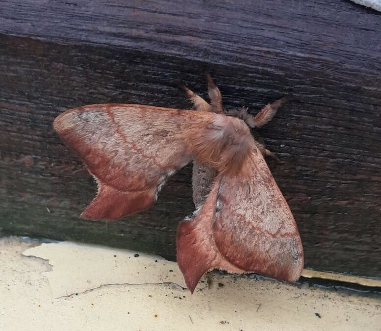
Once is not always the norm aboard the sailing vessel Milagro — and following Callisphyris leptopus Philippi: in mid-April 2026, with Ben, Milena, Gabriel, Damien and Lauriane, as we were leaving one of the arms of Bahía Tres Brazos, a bay located to the north-west of Gordon Island, we received a new visitor that would give us quite a headache: an adult male Cercophana frauenfeldii.
We will not hide from you that identifying this species was no easy feat — friends and acquaintances alike were all astonished by our photographs. After checking the GBIF database, we found that our observation appears to be among the southernmost research‑grade records of Cercophana frauenfeldii currently available there. This underlines how integrating opportunistic observations into open platforms such as iNaturalist and GBIF can complement existing Chilean work by documenting species in remote places where access and sampling are logistically demanding.
Photographed aboard the sailing vessel Milagro, mid-April 2026 in the morning, during an expedition in the canals of the Cape Horn Biosphere Reserve.
Here a detailed spotlight on an uncommonly encountered nocturnal visitor in these waters!
Table of Content
Introduction
Cercophana frauenfeldii Felder, 1862 is a large Neotropical Saturniidae endemic to Chile, also known by the English common name "Andean Moon Moth" on account of its Andean range and its resemblance to a "lunar sphinx". Over the last decades, Chilean and South American entomologists have provided key information on the taxonomy, life cycle and host plants of C. frauenfeldii, from its northern range to Magallanes. Recent work has clarified the immature stages, phenology and host associations, laying the groundwork for interpreting new records such as ours.
In the second half of the 20th century, C. frauenfeldii was incorporated into syntheses on the Chilean Saturniidae fauna, particularly in revisional works on the family and the genera Cercophana and Neocercophana. More recent studies (2021) have complemented these approaches by describing the immature stages (egg, larva, caterpillar, cocoon…), the phenology, the species' distribution and its host plants.
Taxonomy, Morphological Characters and Developmental Stages
1. Original Description and Nomenclatural Status
The species was described by Felder in 1862 under the name Cercophana frauenfeldi, based on material from continental Chile, making it one of the first South American Saturniidae to be formally described. Modern catalogues of the Saturniidae family in Chile confirm this status, retaining the spelling frauenfeldii (with a double "i") as valid and placing it in the genus Cercophana Felder, 1862.
Revisions of the family in South America recognise Cercophana as a small Andean genus restricted to Chile, grouping C. frauenfeldii and a few closely related species including Cercophana venusta, distinct from the neighbouring genus Neocercophana described later for related taxa. Regional catalogues of Argentine Saturniidae also list this species as an element of the trans-border Andean fauna.
2. General Morphological Characters
Works on Chilean Saturniidae describe Cercophana frauenfeldii as a large nocturnal moth with broadly developed wings, varying from brown-ochre to greenish in colour, with lighter patterns and variable transparent or hyaline markings. In adults, sexual dimorphism is expressed through strongly bipectinate antennae in the male, adapted for pheromone detection, while females typically have a more voluminous abdomen associated with egg production.
A recent article in the Brazilian Journal of Entomology, dedicated to the immature stages, describes in detail the egg, the four larval stages, the pupa and the cocoon, providing a complete morphological basis for identification at all stages of development.
3. Immature Stages and Development
The detailed study of the immature stages of Cercophana frauenfeldii shows that larval development comprises four well-differentiated instars, generally spanning from November to late January throughout most of the species' range. The caterpillars feed on the leaves of their host plants, displaying primarily nocturnal activity and concealing themselves among foliage during the day.
Pupation occurs within a silken cocoon whose structure and location may vary depending on habitat conditions, but which is generally situated in the leaf litter or on low-hanging branches.
Geographical Distribution in Chile
1. Latitudinal Gradient and Biogeographical Provinces
Chilean catalogues and syntheses record Cercophana frauenfeldii from the centre of the country to the humid temperate regions of the south, particularly in the Maule, Biobío, La Araucanía, Los Lagos and Aysén regions. A recent compilation of field data and naturalist collections confirms that the species follows an Andean-coastal gradient associated with temperate forests.
TA synthesis of published records and naturalist collections suggests two broad phenological and biogeographical groupings: the northern group, where adults fly mainly from February to mid-April, and the southern group (temperate rainforests), where the main flight period shifts to between April and June (the case of our visitor).
2. Southward Extension and the Magallanes Region
Works specifically addressing the Magallanes region highlight that C. frauenfeldii reaches the southern part of continental Chile, where it remains more localised. An article focused on the host plants of this moth confirms the presence of populations in temperate forests close to the southern limit of distribution of the host tree species, primarily belonging to three families: Gomortegaceae, Lauraceae and Winteraceae. The plants most represented in the studies conducted are Cryptocarya alba, Beilschmiedia miersii, Gomortega keule and Persea americana, all of which develop further north than our visitor.
While published records are concentrated mainly at sites further north than the Chilean Antarctic province where we explore, records from the Magallanes region make the species' presence in sub-Antarctic archipelagos plausible. According to observations made in 2003 in Parque Omora (Puerto Williams), this moth also uses the canelo or Magellan pepper (Drimys winteri) as a host plant, and this tree is ubiquitous in the Province of Cabo de Hornos.
The most recent works stress the need to better document the fine-scale distribution, phenotypic variability and population genetics of Cercophana frauenfeldii from the north-central to the far south of Chile.
Scientific Significance of This Local Record
Although this record has not yet been incorporated into Chilean academic syntheses, it is fully consistent with the documented distribution of C. frauenfeldii as far south as Magallanes and with the continuity of native forests in the region. Rather than revealing a major range extension, the observation adds a documented island locality within the Cape Horn Biosphere Reserve, in line with previous work from Magallanes and with the widespread presence of the host tree Drimys winteri in the Province of Cabo de Hornos.
This single opportunistic record does not allow any inference about population size, persistence or trends on Gordon Island. It should therefore be interpreted as an initial indication of presence rather than the result of a systematic survey. Nevertheless, it illustrates how small‑scale observations can help refine the fine‑scale distribution of forest‑associated moths in southern Chile, especially in sub‑Antarctic archipelagos that are logistically difficult to sample.
In the far south of Patagonia, targeted nocturnal sampling campaigns—combining light‑based methods with searches for larvae on potential host plants, ideally in collaboration with Chilean entomologists and institutions—would be needed to confirm and quantify the presence of C. frauenfeldii on Gordon Island and neighbouring islands. On‑board naturalist monitoring programmes such as those conducted by Association Karukinka can contribute complementary observations to national and international entomological databases, but they are best seen as a small part of a broader, long‑term research effort led by Chilean teams.
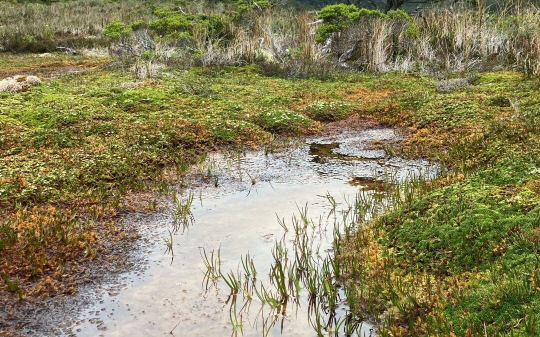
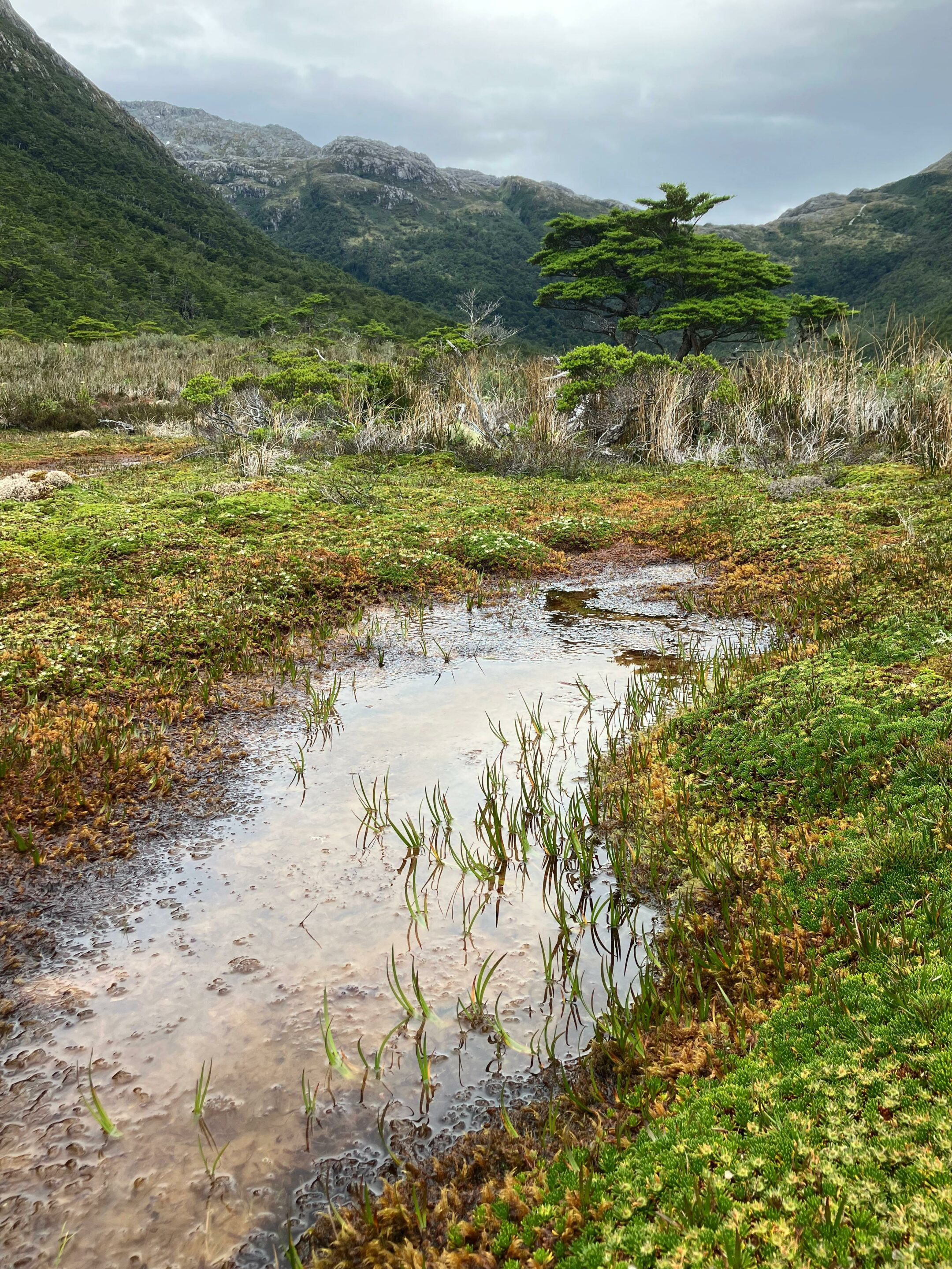
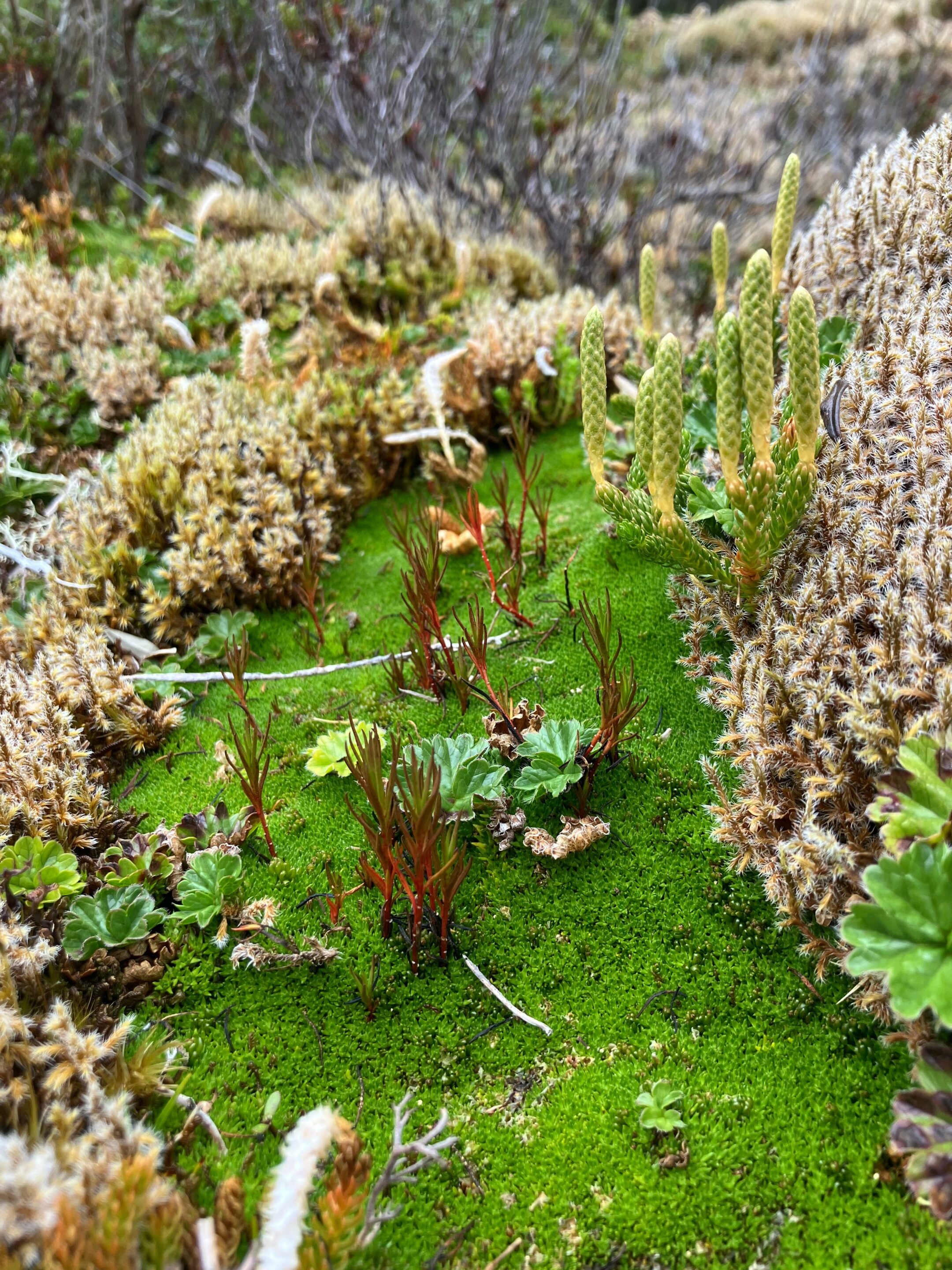
In the peatlands of Tierra del Fuego and the Cape Horn Biosphere Reserve, two groups of non-vascular plants quietly rule over landscapes that might seem hostile to any form of dense life: peat mosses (Sphagnum) and liverworts. Tiny to the naked eye, these bryophytes nevertheless structure one of the carbon-richest and most biodiverse ecosystems in the Southern Hemisphere. Aboard the sailing vessel Milagro, during our expeditions through the southern channels of Tierra del Fuego, we observed them everywhere — on the bark of southern beeches (Nothofagus), on spray-battered shoreline rocks, on the spongy soils of the peat bogs. These are the plants that form the "miniature forests" described by biologist Ricardo Rozzi and the research team at Parque Omora.
Peatlands in Gordon island, Expedition Karukinka, February 2026
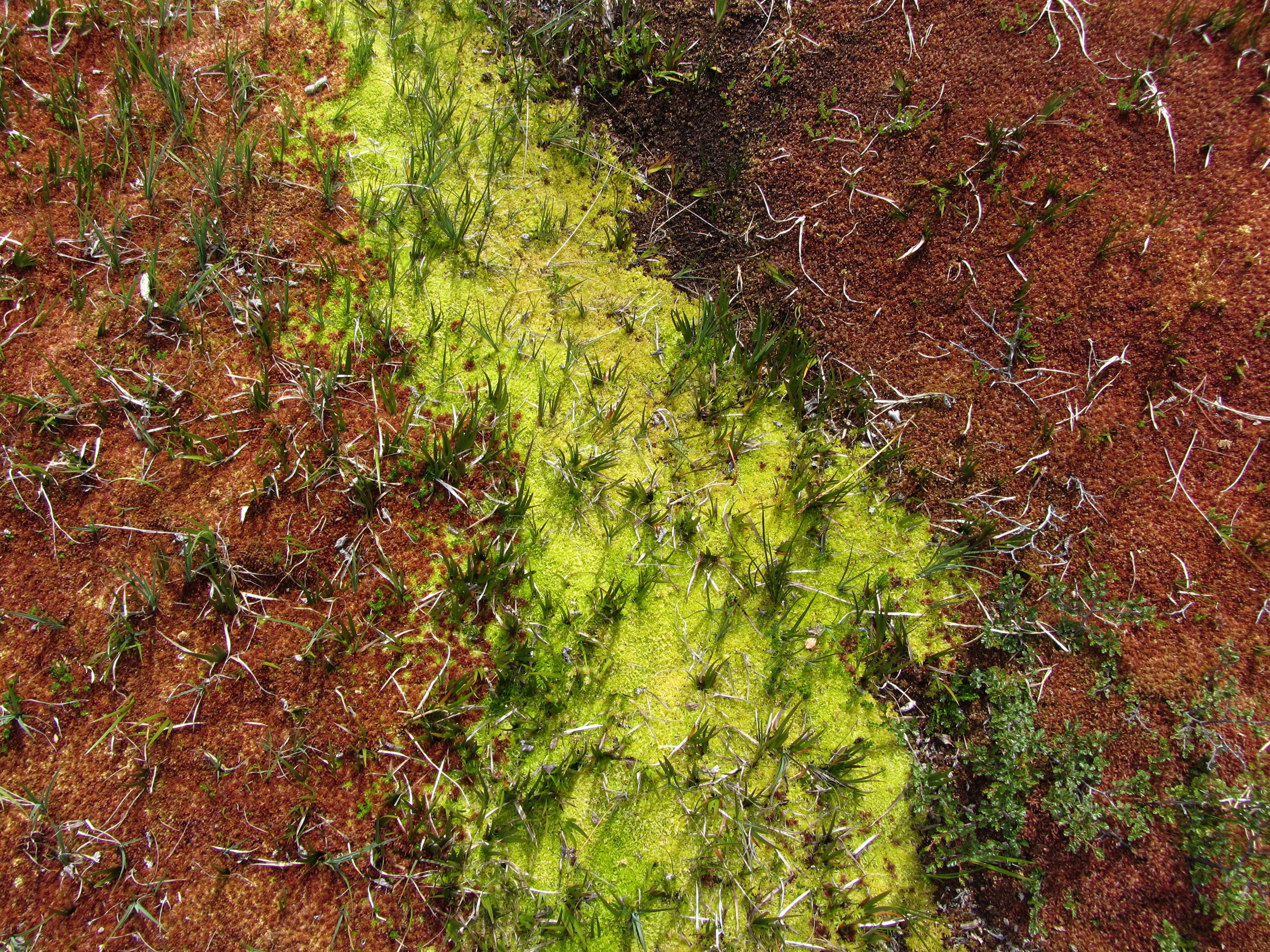
Sphagnum peatlands: sponges of carbon and water
Tierra del Fuego's peatlands formed between 15,000 and 10,000 years BP, in the wake of the last Quaternary glaciation. Today they cover a significant share of the landscape of the Isla Grande (notably the Mitre Peninsula), particularly in the wettest and least disturbed areas south of the Strait of Magellan.
The dominant species is Sphagnum magellanicum Brid., known locally as musgo pompón. This peat moss structures the peatland matrix by saturating soils with water, lowering pH and slowing the decomposition of organic matter — processes that lead to peat accumulation over sometimes considerable depths. The associated ecosystem services are multiple: regulation of hydrological processes, carbon capture and storage, habitat provision, and maintenance of water quality.
Within the peat itself, floristic composition is remarkably homogeneous. The environmental factor that best explains compositional variation between peatlands is water table height rather than species richness — underlining the importance of an intact hydrological regime for the conservation of these ecosystems.
On the Argentine side of the Isla Grande, the glacial valley of Carbajal, north of Ushuaia, flanked by the Sierra Alvear and drained by the Río Olivia, hosts an extensive domed peat plain dotted with lagoons. This site has become a pilot research area for Argentine science on subantarctic peatlands. Studies conducted by CADIC/CONICET and partner institutions use the Carbajal wetland as a case study to quantify carbon stocks, analyse the hydrological regulation role of these peatlands for Ushuaia, and assess the impacts of peat extraction on ecosystem stability.
A global bryophyte hotspot
The Cape Horn Biosphere Reserve is recognised as one of the world's centres of bryophyte diversity. On less than 0.01% of the world's land surface, the region concentrates more than 5% of all known bryophyte species, with a high proportion of endemics. Across the reserve, more than 300 liverwort species and 450 moss species have been recorded.
This richness is a direct product of climatic conditions: the humid temperate forests receive abundant rainfall in a remarkably pure atmosphere, free of air pollutants. The bryophytes and lichens that colonise trunks, rocks and soils are poikilohydric — capable of suspending their metabolism during temporary drought and resuming it rapidly upon rehydration — which makes them particularly resilient to freeze-thaw cycles.
During the Milagro expedition of February 2026, lichens and liverworts were observed and photographed at several sites on Gordon Island. Their identification benefited from the assistance of Ricardo Rozzi and José German Gonzalez Calderon, to whom the team extends its gratitude.
Liverworts: pioneers and indicators
Liverworts (division Marchantiophyta) form a distinct group within bryophytes, separate from mosses and hornworts. In the subantarctic forests of Cape Horn, they preferentially colonise Nothofagus trunks, dead wood and humid woodland edges, forming flat or cushion-shaped mats of a characteristic deep green.
Their sensitivity to atmospheric conditions makes them excellent bioindicators of air quality and ecosystem integrity. The Omora Ethnobotanical Park (Puerto Williams) uses them as educational mediators with local schools, to anchor in children an awareness of the global value of their territory's biodiversity.
Ecological roles in forests and bogs
In humid subantarctic forests, peat mosses and liverworts form thick mantles capable of retaining large quantities of water and regulating local moisture. They act as natural sponges, buffering the impact of frequent rainfall, limiting erosion and stabilising micro-habitats.
In the peatlands, peat mosses structure the saturated matrix that simultaneously stores water and large amounts of carbon — a role of particular strategic importance in the context of climate change. Precipitation in Patagonia is estimated to decrease by 10–20% by the end of the century, which would directly threaten the hydrological integrity of these ecosystems.
Peatlands of Tierra del Fuego photographed in Carbajal Valley (February 2013, cc Sébastien Pons)
Lichens, frequently associated with bryophytes on the same substrates, play a pioneer role on bare rock and glacial moraines, initiating soil formation that will later allow mosses and then vascular plants to establish themselves.
Threats and conservation
Bryophyte communities remain vulnerable to trampling, hydrological modification and the long-term effects of climate change. Disturbances caused by introduced species — particularly the North American beaver (Castor canadensis), introduced to Tierra del Fuego in the 1940s — profoundly alter watercourses and peatlands, indirectly modifying the substrates and microclimatic conditions that these miniature forests require.
Commercial harvesting of Sphagnum magellanicum for horticulture represents an additional pressure: this activity began around twenty years ago further north, in the Los Lagos and Magallanes regions, and its impact on natural populations is the subject of ongoing sustainable management efforts.
At the southeastern tip of the Isla Grande, the Mitre Peninsula extends this peatland belt toward the Atlantic. This almost uninhabited headland concentrates approximately 84–85% of Argentina's total peatland area: nearly 193,000 hectares of peat bogs out of a provincial total estimated at 270,000 hectares. In December 2022, Provincial Law No. 1461 created the Área Natural Protegida Península Mitre, integrated into Tierra del Fuego's protected-area system. Studies coordinated by CADIC/CONICET and local organisations show that these peatlands rank among Argentina's largest carbon reservoirs: they store the equivalent of several years of national carbon dioxide emissions, and have been recognised by the United Nations Environment Programme as one of the eleven most important peatland ecosystems on Earth.
Ecoturismo con lupa: seeing the world differently
To promote and protect this discreet biodiversity, the Omora Park team developed the concept of Ecoturismo con lupa (hand-lens ecotourism): an approach that places the discovery of mosses, liverworts and lichens at the centre of the visitor experience, within a "field environmental philosophy". Armed with a simple magnifying glass, visitors are guided to observe the bosques en miniatura and understand their ecological role.
This approach, documented in the film Viaje Invisible. Ecoturismo con Lupa (2013), illustrates how millimetre-scale biodiversity can transform a forest walk into a fully-fledged scientific exploration.
Bibliography
DOMÍNGUEZ, E. et al. Floristic biodiversity present in Sphagnum peatland bogs. Anales del Instituto de la Patagonia, 2021.
GOFFINET, B., ROZZI, R., MASSARDO, F. et al. Miniature Forests of Cape Horn: Ecotourism with a Hand Lens. University of North Texas Press, 2012.
ODEPA/INFOR. Musgo Sphagnum: manejo sostenible del recurso. Gobierno de Chile, 2018.
PIONTELLI, E. Sphagnum magellanicum Brid. en Chile. Boletín Micológico, 2008.
ROZZI, R. (coord.). Ecoturismo con lupa en el Parque Omora. Universidad de Magallanes.
SALINAS, J. et al. Generando conocimiento para el desarrollo de cultivos sustentables de Sphagnum. Revista INFOR, 2021.
VILA, I. et al. Ictiofauna en los sistemas límnicos de la Isla Grande de Tierra del Fuego. Revista Biología Marina, 1999.
VILLAGRA, J. et al. Sphagnum peatland bog, Magallanes. Anales del Instituto de la Patagonia, 2004.
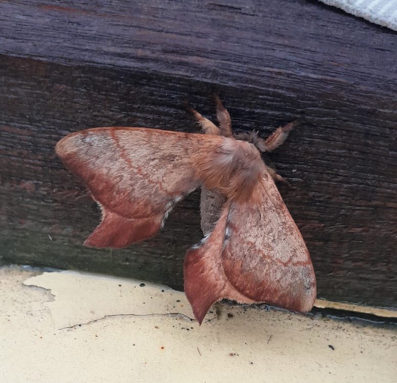
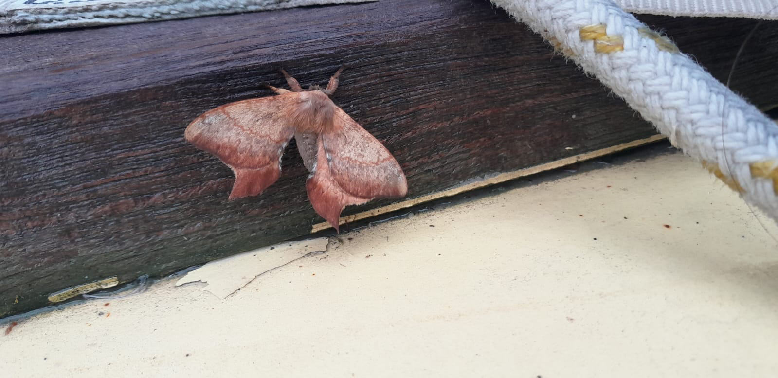
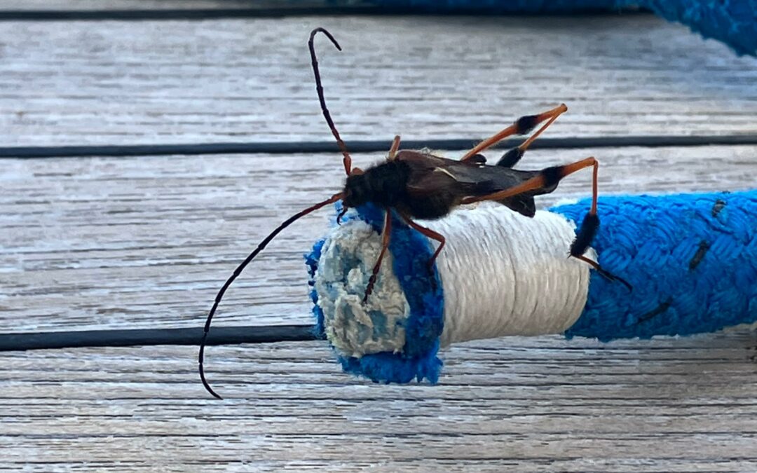
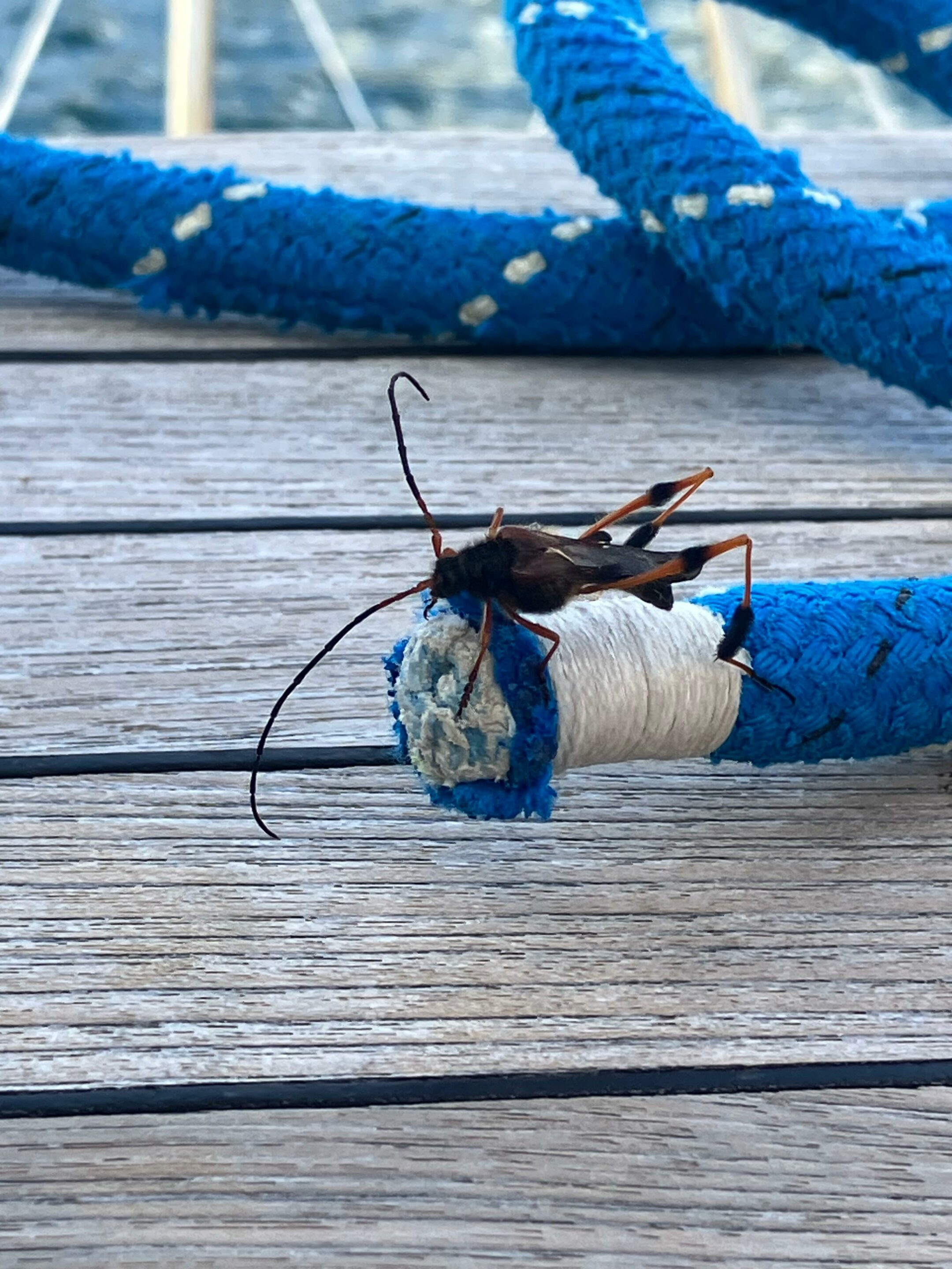
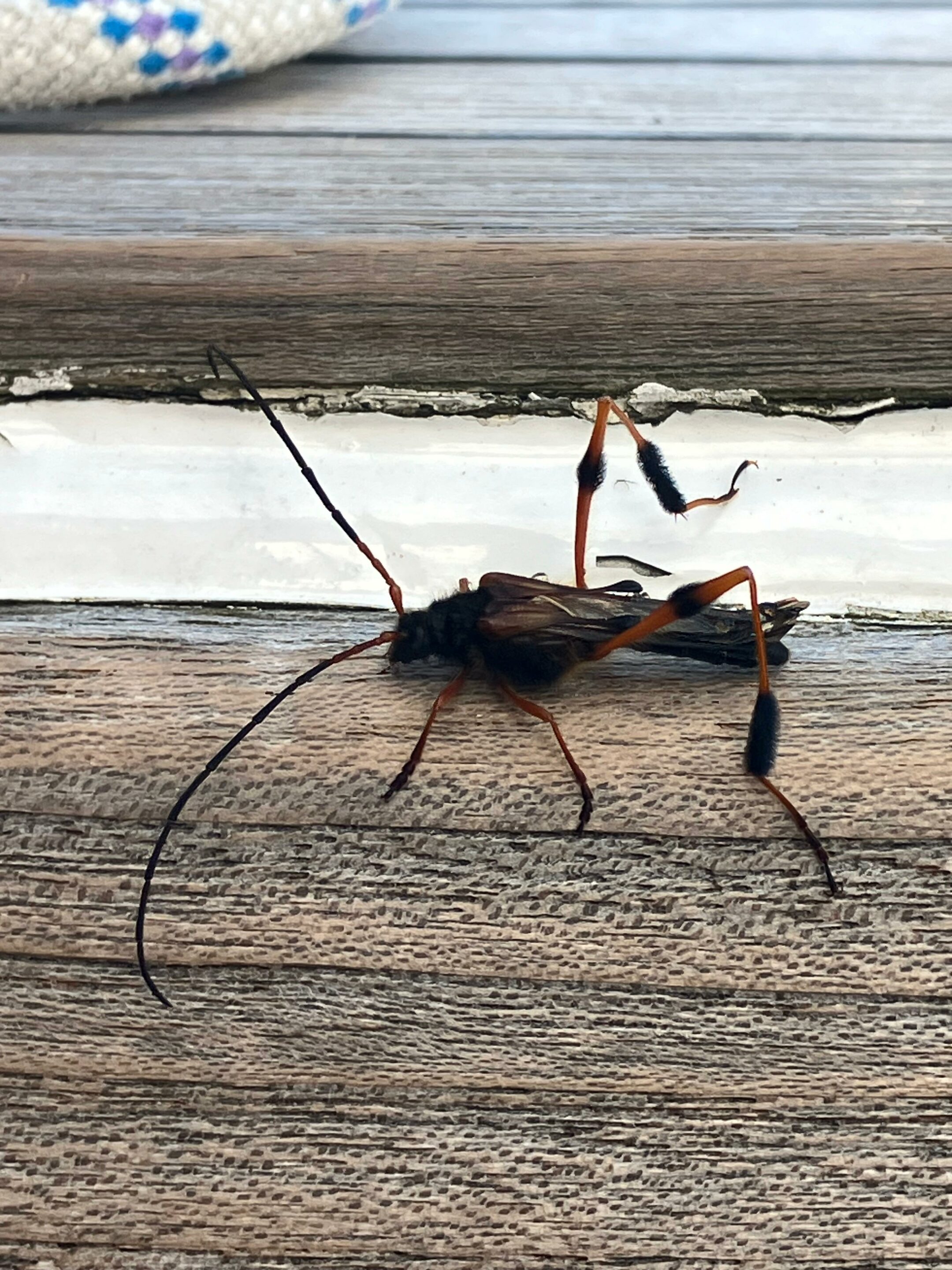
At first glance, this insect might look like a slender wasp lost far from its nest. Yet, this specimen observed aboard the Milagro on April 9, 2026, north-east of Hoste Island—while the ship was anchored in a forest-lined area battered by bad weather—belongs to an entirely different world: that of the southern longhorn beetles, which remain very poorly documented.
Callisphyris leptopus philippi visiting the sailing boat Milagro April 9, 2026 (Karukinka Expedition, Hoste Island, Cape Horn Biosphere Reserve, Chile)
In this context, the encounter takes on real scientific significance. Callisphyris leptopus Philippi, 1859 belongs to the Cerambycidae, the "longhorn beetles," a family of beetles of which many species spend a large part of their development inside wood. The case of this species is particularly interesting because, despite its spectacular appearance, easily accessible documentation remains fragmentary, scattered among taxonomic records, forestry publications, and isolated sightings.
A species of the southern forests
Available sources place Callisphyris leptopus in southern America, with an established presence in Chile and the subantarctic forests of southwestern Argentina. The FAO forestry manual dedicated to insects damaging branches, shoots, and seedlings specifies that the species is reported in Chile from the Maule region down to Magallanes and the Chilean Antarctic, as well as in Argentina within the subantarctic forests.
This distribution is not insignificant. It associates the insect with the cold temperate forest landscapes dominated by Nothofagus, an emblematic group of trees in subantarctic and Andean Patagonia. The Titan-GBIF page also explicitly links to a "Plants" section, indicating that understanding the species requires looking at its close ties with its host plants.
Well-identified forest hosts
The consulted forestry literature associates Callisphyris leptopus with several species of Nothofagus, notably the coihue, raulí, lenga, and ñirre. The larvae develop in branches or young stems, where they burrow galleries in relatively soft woody tissues.
An Argentine article detailing an individual found south of Ushuaia provides a very concrete testimony on this matter. The consulted experts describe the insect as a "perforador o taladrador de madera" (wood borer or driller), which "por lo general hace túneles en maderas jóvenes y blandas" (generally makes tunnels in young and soft wood) and is usually linked to the ñirre, without excluding the lenga as a possible host plant in this instance.
Size, shape, and mimicry
The adult has an elongated body and a unique silhouette, very different from the common image of a stocky beetle. According to the forestry record, the female reaches about 36 mm in length and 8.5 mm in width, while the male measures about 26 mm long and 6 mm wide. These dimensions belong to a visible, yet not massive insect, whose long legs further accentuate the impression of slenderness.
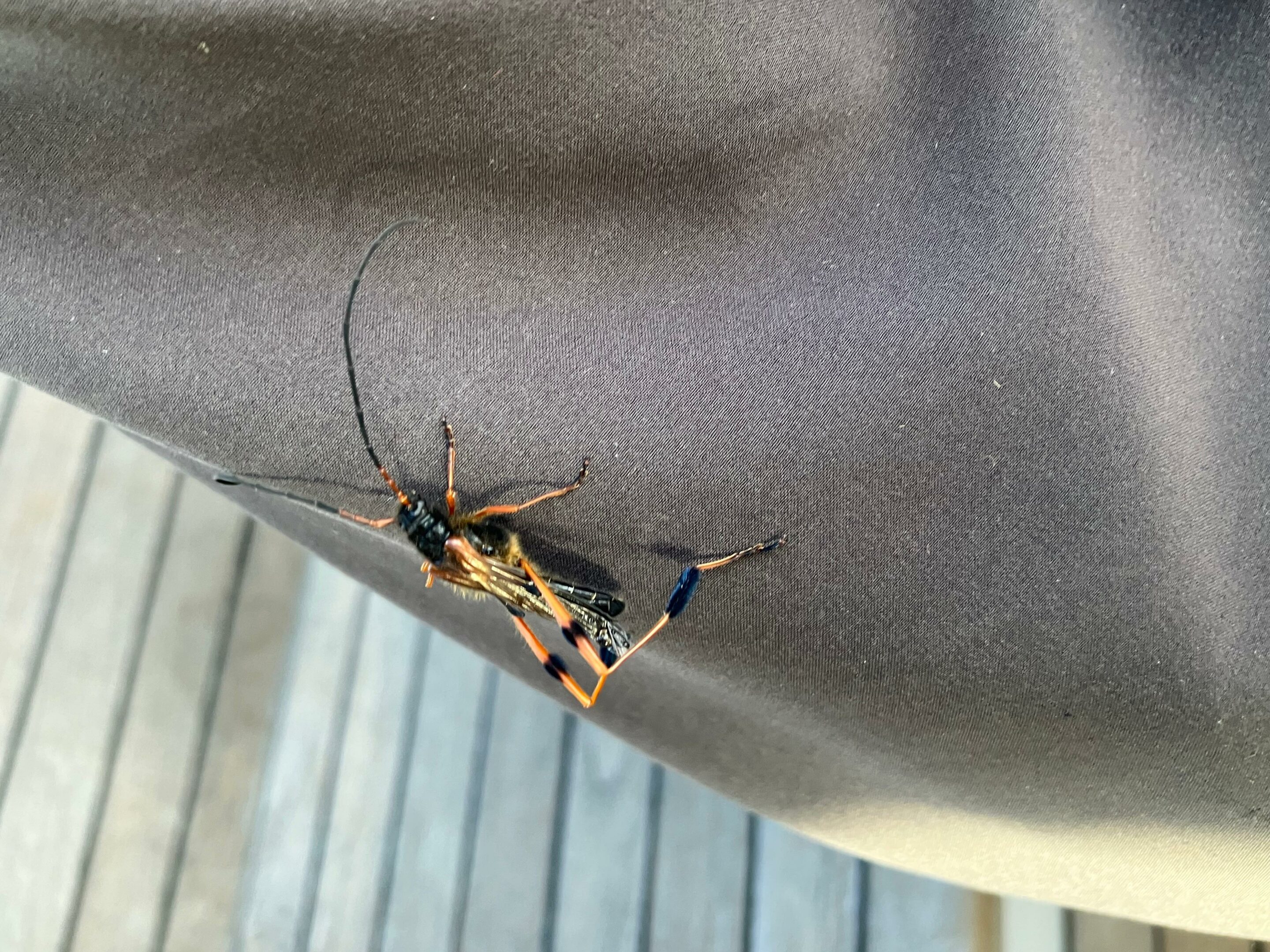
Callisphyris leptopus philippi visiting the sailing boat Milagro April 9, 2026 (Karukinka Expedition, Hoste Island, Cape Horn Biosphere Reserve, Chile)
Its appearance is one of its most striking features. The article published in Argentina highlights that this cerambycid beetle "trata de imitar al de las avispas" (tries to mimic the appearance of wasps), explaining that this mimicry serves to deter potential predators such as birds or small mammals. The Titan-GBIF page reinforces this interpretation down to the species' etymology: leptopus derives from the Greek leptos ("thin, slender") and pous ("foot"), literally meaning "with slender legs."
A largely hidden life cycle
Like many longhorn beetles, Callisphyris leptopus spends most of its life out of human sight. The larval stage takes place inside the wood, in galleries that can be long and winding. The FAO document mentions a biological cycle of about four years, with larvae developing in twigs and branches before the adults emerge in spring.
The article from Diario Prensa Libre completes this picture with more accessible field observations. The experts state that the insect can "vivir dos o tres años en el interior del árbol, haciendo galerías" (live two or three years inside the tree, making galleries), before emerging to reproduce and die. Even though exact durations vary according to sources, they all agree on one essential point: the adult is only a brief apparition at the end of a long, hidden existence within the tree.
A harmless but precious insect to observe
The Argentine article identifies the specimen observed in Ushuaia as an adult female, recognizable notably by the absence of the divided antennae attributed to the male in this account. It also mentions a remarkable detail: the legs bear hairs "like little brushes," to which fungal spores can adhere, later deposited on rough surfaces or in cavities during egg-laying.
The same article emphasizes an important point for the general public: the insect does not sting and poses no danger to humans. If an individual is encountered, the best course of action is simply to let it go on its way.
Why the observation aboard the Milagro matters
An insect found aboard a sailboat or an anchored ship might seem like a mere anecdote. In the case of Callisphyris leptopus, it is, on the contrary, a data point that deserves to be preserved, described, and placed in its ecological context. The species remains scarce in accessible synthesis literature, even though it possesses a distinctive morphology, a long life cycle, and a close link to southern forests that are themselves difficult to fully inventory.
Callisphyris leptopus philippi visiting the sailing boat Milagro April 9, 2026 (Karukinka Expedition, Hoste Island, Cape Horn Biosphere Reserve, Chile)
The context of the sighting further enhances its interest. A specimen landing aboard the Milagro during a storm, in a location bordered by forests, suggests movement facilitated by the wind or by adult flight activity in the immediate vicinity of its forest habitat. Without turning an isolated observation into definitive proof, this type of encounter reminds us how crucial naturalist exploration remains in the southern archipelagos, channels, and forest edges, where much data still relies on chance discoveries rather than continuous monitoring series.
In southern regions, where weather conditions often complicate fieldwork, every well-dated, localized, and illustrated observation can significantly enrich the knowledge of still poorly monitored species. The visit of Callisphyris leptopus aboard the sailboat Milagro is therefore not just another curiosity: it is a clear reminder that exploration remains a method of knowledge-gathering, sometimes triggered by a simple flutter of wings in the heart of a storm.
FAO. Insectos dañadores de ramas, brotes y plantulas. Technical manual mentioning Callisphyris semicaligatus as a synonym and describing its distribution, host plants, morphology, and biological cycle.
GBIF Backbone Taxonomy. Callisphyris leptopus F. Philippi, 1859, species profile and occurrences.
Titan / GBIF France. "Cerambycidae (Longhorns)", record for Callisphyris leptopus R. Philippi, 1859, with etymology and access to distribution and host plant sections.
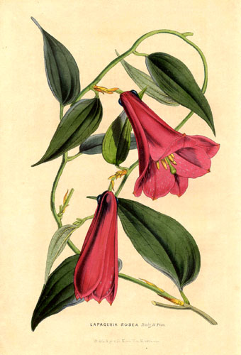
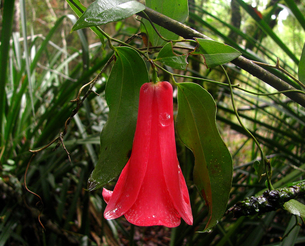
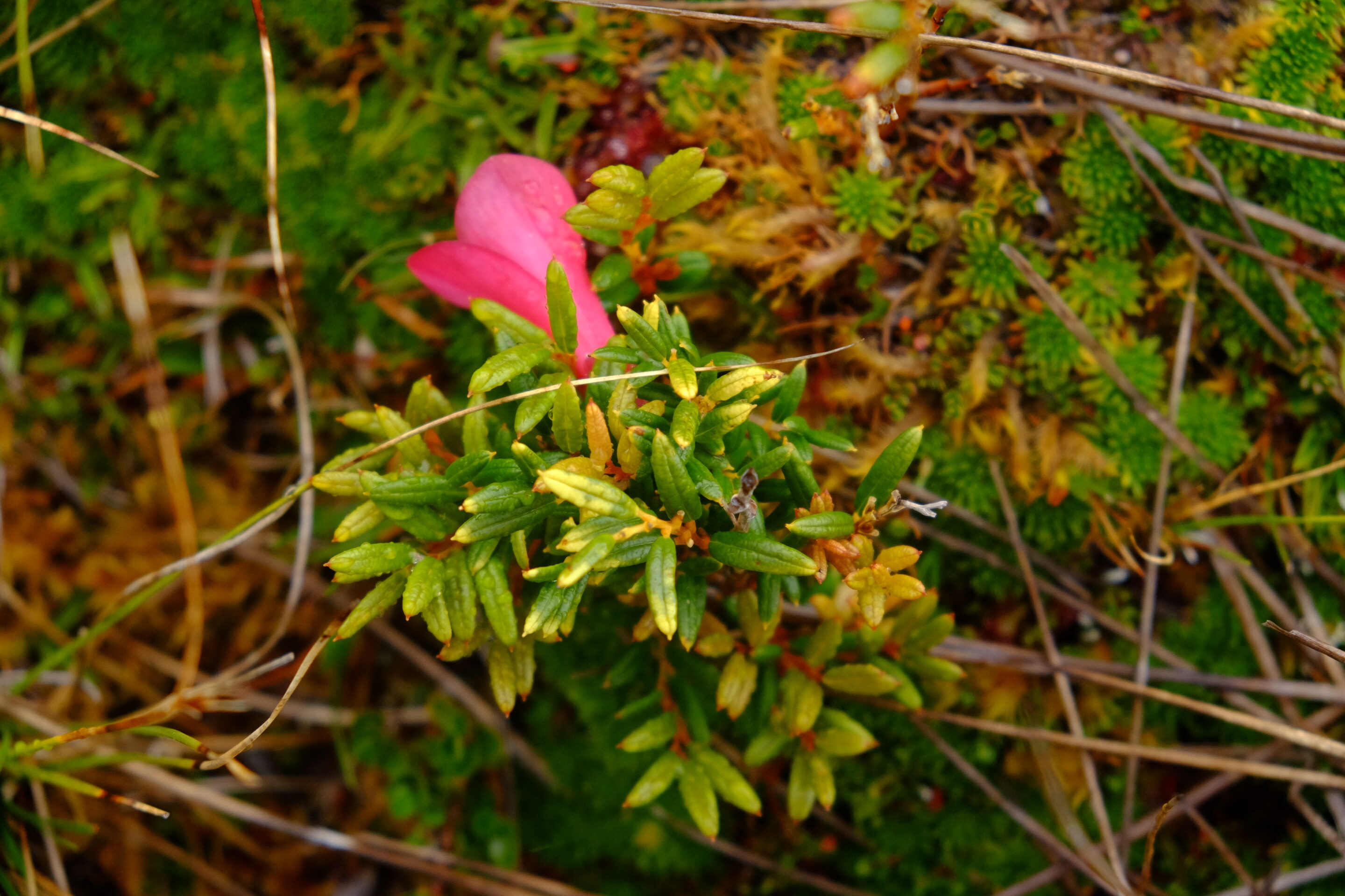
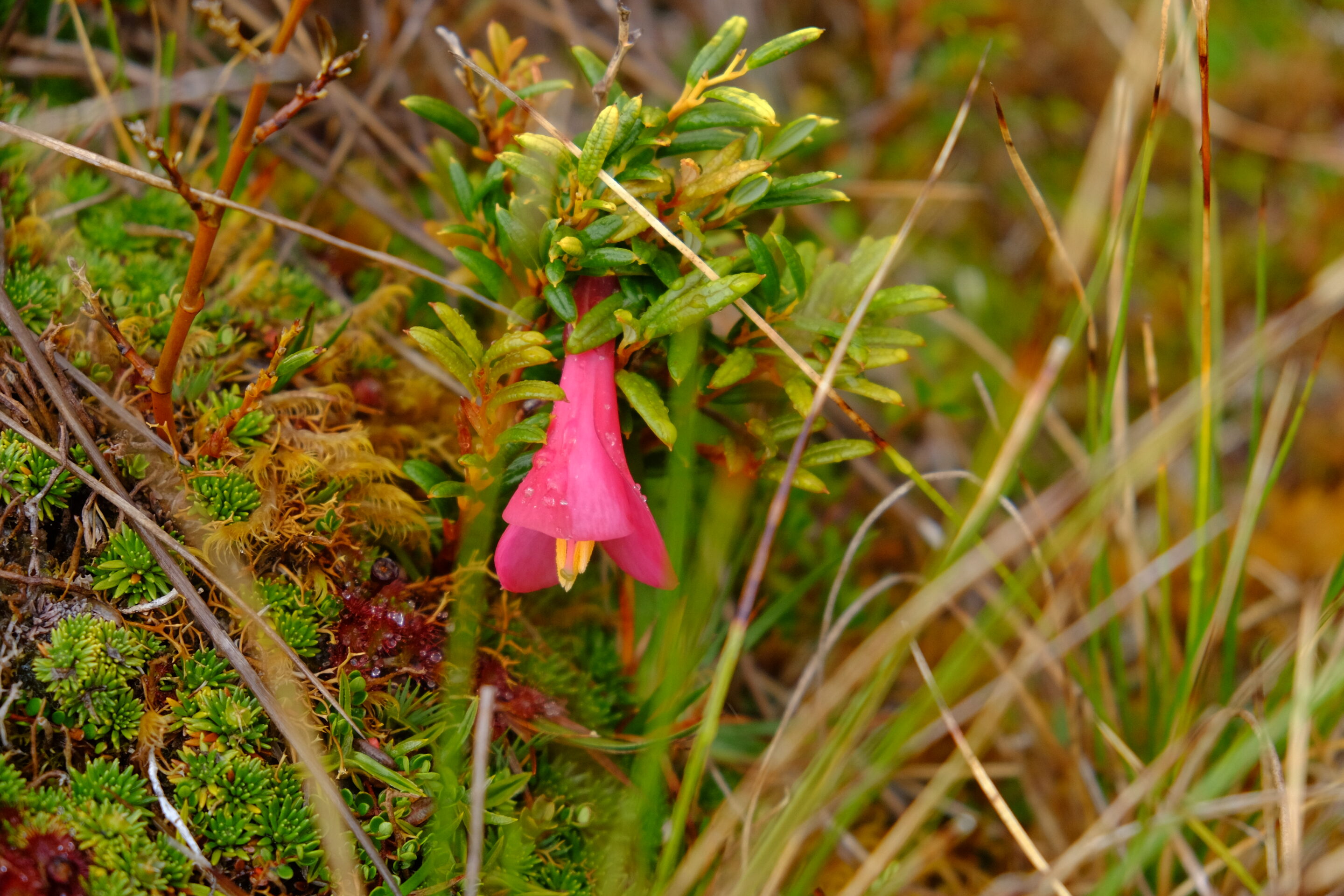
The copihue (Lapageria rosea) and the coicopihue (Philesia magellanica) are two closely related species, both belonging to the Philesiaceae family and native to the temperate and subantarctic forests of Chile.
They resemble each other with their red bell-shaped flowers, but a few morphological, growth, and distribution traits make it possible to clearly distinguish them in the field:
Table of Content
1. Plant habit: a large climbing vine vs a small bush
The copihue (Lapageria rosea) is a climbing vine that can reach more than 10 meters in length, twining around the trunks and branches of Nothofagus, Fitzroya, and other trees of the Chilean forest. Its thin, flexible stems give the impression of a plant climbing from the understory into the lower canopy, with vertical and airy foliage.
Lapageria Rosea or Copihue, public domain, https://commons.wikimedia.org/w/index.php?curid=39275
The coicopihue (Philesia magellanica), on the other hand, is mostly a small branching shrub, 1 to 3 meters high, which spreads into dense bushes through stolons and numerous secondary stems. It barely climbs, stays close to the ground, and often covers slopes, mossy rocks, or the edges of Alerce forests as a compact mass of tightly packed stems.
2. Leaves: large and veined vs small and narrow
The leaves of the copihue are alternate, long (5–10 cm), broad, and ovoid, with 3 to 5 very pronounced parallel veins that give the leaf an almost "molded" appearance. They are leathery, shiny, and highly visible along the twining stems, contributing to its imposing silhouette in the forest.
The leaves of the coicopihue, conversely, are smaller, narrow, almost linear, rigid, and end in a fine point. Dark green in color, they align tightly along thin stems, giving the plant a compact and bushy appearance, more discreet on the ground than above the trees.
Copihue flower photographed by Inao Vásquez from Santiago, Chile - Copihue, CC BY-SA 2.0, https://commons.wikimedia.org/w/index.php?curid=11944192
Coicopihue flower and leaves photographed during an expedition organized by Karukinka (Chair island, Cape Horn Biosphere Reserve, February 2025)
3. Flowers and fruits: large open bells vs narrow bells
The copihue flower is a large hanging bell, 5 to 10 cm long, made of six thick, waxy, red or pink tepals, often streaked with white lines. Three short outer tepals are shorter, while three longer inner tepals curve outward, allowing the flower to open widely and reveal its abundant nectar, making it an attractive resource for hummingbirds.
The coicopihue flower is a smaller, short hanging bell of 5–6 cm, with petals that are tighter and open less. Their shape remains more tubular and closed, giving a more compact and less deployed appearance than that of the copihue, even though the red-pink color remains similar.
Both produce edible red berries, but those of the copihue are larger and more frequently used locally, whereas the berries of the coicopihue remain modest and scarce.
4. Distribution and habitat: further north versus further south
The copihue (Lapageria rosea) grows mostly from Valparaíso down to the Los Ríos region, in humid evergreen forests along streams, rivers, or shaded slopes, where the soil is rich and well-drained. It favors shaded valley forests at low altitudes, where humidity and protection from direct sunlight promote the vine's growth.
The coicopihue (Philesia magellanica) extends from Los Ríos down to the channels of the Cape Horn Biosphere Reserve, including the Andes mountain range (up to about 1,000 m) and the highlands of Chiloé. It tolerates heavier soils, sometimes poorly drained or even swampy (Ñadi, Hualve, tepuales types), which explains its presence in wetlands, peat bogs, and the edges of Alerce or subantarctic Nothofagus forests. Within Karukinka, we have observed it mostly on Chair Island, creeping on the damp walls of the anchorage named "Caleta Alukush" (named after the steamer ducks in Yagan) and in the heart of this small island located between Gordon Island, the fjords of the Darwin Range (Tierra del Fuego), and O'Brien Island.
Coicopihue flower and leaves photographed during an expedition organized by Karukinka (Chair island, Cape Horn Biosphere Reserve, February 2025)
5. Cultural role and how to recognize them in the field
The copihue is the national flower of Chile, declared an official symbol in 1977, and holds a central place in popular culture, art, music, and Mapuche symbolism, where it notably embodies joy, solidarity, and resistance. It is often cited in heritage tales, on tourist materials, and regional emblems, making it an easily recognizable reference.
The coicopihue is perceived as a kind of "discreet sister" to the copihue, mostly present in the southern, insular (Chiloé), and high cordillera regions, where it blooms in more demanding and often foggy landscapes. In the field, it stands out by its smaller size, bushy habit, tight bells, and its often swampy or subantarctic environment, whereas the copihue is distinguished by its large climbing vine, its large open flowers, and its valley forest environment further north.
Bibliographic references
Coronado, B. et al. (2025). Revisión de las especies Lapageria rosea y Philesia magellanica: bases para la propagación y conservación de la familia Philesiaceae en Chile. Universidad de Concepción, Facultad de Agronomía y Recursos Naturales, repositorio UdeC. Available online: https://repositorio.udec.cl/items/8448e141-02f1-4623-bfc4-598237f6023c
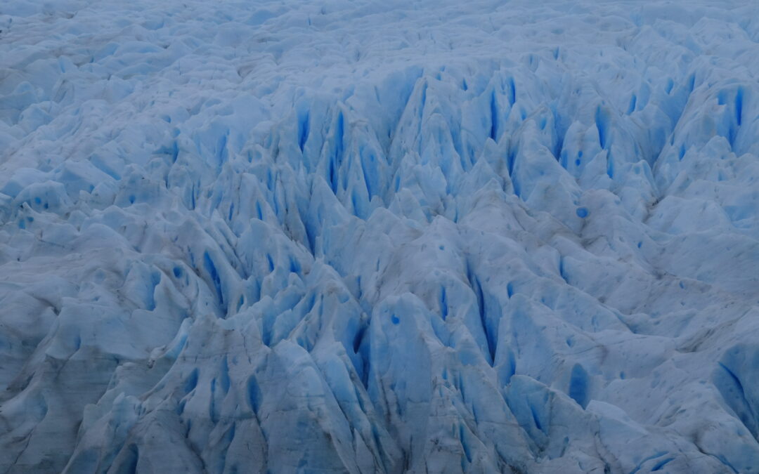
Law 26.639, also know as Ley de Glaciares and enacted in 2010, established in Argentina the Minimum Budgets Regime for the Preservation of Glaciers and the Periglacial Environment, legally cementing the idea that glaciers are strategic freshwater reserves and public goods. Starting in 2025–2026, the national government pushed forward a project for a comprehensive modification of this norm (File 0161-PE-2025), which obtained half-sanction in the Senate and approval from the Chamber of Deputies, generating strong political and social conflict.
Karukinka Expedition (Fouque Glacier, 2025)
This article outlines the core content of the existing law, the main adopted modifications, the role of the provinces, as well as the social mobilizations and the interventions of Indigenous peoples—notably the Selk'nam jurist Antonela Guevara—who denounce the potential impacts of this reform (risks to water, ecosystems, and territorial rights).
Table of Contents
Law 26.639 (2010): content and scope
Purpose and principles
Article 1 of Law 26.639 sets the objective of establishing minimum budgets for the protection of glaciers and the periglacial environment, recognizing them as strategic reserves of water resources for human consumption, agriculture, watershed recharge, biodiversity protection, scientific research, and tourism. Glaciers are explicitly declared public goods.
The Library of Congress highlights that this law falls under the framework of Article 41 of the National Constitution (right to a healthy environment, national minimum budgets) and the General Environmental Law 25.675, which enshrines the principles of prevention, precaution, and non-regression.
Definitions: glacier and periglacial environment
Article 2 defines a glacier as any perennial ice mass, stable or slowly flowing, formed by the recrystallization of snow, regardless of its shape, dimension, or state of conservation; this includes rocky detrital materials and internal or superficial watercourses.
The periglacial environment is defined, in high mountains, as the area of frozen soils that acts as a water regulator, and in medium and low mountains, as the area with ice-saturated soils that plays the same regulatory role. These very broad definitions extend the scope of protection to forms of ice and frozen soils that go beyond just large visible glaciers.
National Glacier Inventory of Argentina (ING)
Articles 3 and 4 create the National Glacier Inventory, entrusted to the Argentine Institute of Nivology, Glaciology and Environmental Sciences (IANIGLA-CONICET), tasked with identifying all glaciers and periglacial landforms acting as water reserves, including their location, surface area, typology, and the variables necessary for their protection and monitoring.
The Legislative Dossier of the Library of Congress notes that Decree 207/2011 specified the organization of the ING by major glaciological regions (Desert, Central, Northern and Southern Patagonian Andes, Tierra del Fuego, and South Atlantic Islands) and mandated an update at least every five years.
Prohibited activities
Among its most important provisions, the law prohibits certain activities in glaciers and the periglacial environment, particularly:
mining and hydrocarbon exploration and exploitation;
the installation of industries;
the construction of works or infrastructure that could alter the natural dynamics of the ice or water quality (except for scientific research);
the storage or handling of contaminating or hazardous substances.
Any activity that may significantly affect these environments must be subject to a prior environmental impact assessment, in accordance with the General Environmental Law.
The 2025–2026 reform project: objectives and core modifications
Political context and stated objectives
In December 2025, the national executive branch submitted to the Senate Expediente 0161-PE-2025, aiming to amend Law 26.639, arguing the need to correct "interpretative flaws," lift legal uncertainties, and facilitate investments, particularly in mining. According to an analysis by Infobae, the executive presents the reform as a way to strengthen "environmental federalism" by giving provinces a greater role in managing their resources.
The project obtained 40 votes out of 72 in the Senate (40 in favor, 31 against, 1 abstention), with the support of part of the Radical Civic Union, Pro, and Peronist senators from mining provinces, before being passed to the Chamber of Deputies. In the lower house, the reform was ultimately approved by 137 votes in favor, 111 against, and 3 abstentions, and then sent to the executive for promulgation.
Redefinition of the inventory: "that act as reserves"
One of the most significant changes concerns Article 3 of the law, relating to the National Glacier Inventory. The new text, as described by the newspaper Ámbito, now stipulates that the ING will inventory glaciers and periglacial areas that "act as strategic reserves of water resources," instead of those that "fulfill the functions" of a reserve.
This substitution seems minor lexically, but the Library of Congress Dossier points out that it contributes to a re-definition of the extent of protected areas, by conditioning protection on the demonstration of an effective hydrological function rather than the mere presence of perennial ice. Provincial authorities are called upon to play a central role in this assessment.
Precautionary principle and possibility of subsequent exclusion
The reform introduces an Article 3 bis, which specifies, according to the text analyzed by Ámbito, that:
all glaciers and periglacial areas registered in the inventory will be considered part of the protected object until the competent authority verifies the non-existence of the hydrological functions defined in Article 1;
further on, it stipulates that when it is determined, based on technical-scientific studies, that a glacier or periglacial area "does not fulfill the intended functions," it may be considered excluded from the protected object.
We thus shift from a broad presumption of protection (any perennial ice mass in a periglacial environment) to a logic where the Inventory becomes a filtering tool, with the possibility of declassifying glacial units based on specific analyses.
Terminology: from "periglacial environment" to "periglacial landforms"
Several terminological modifications replace the expression "periglacial environment" with "periglacial landforms" (geoformas periglaciares) in the articles relating to the inventory and the competencies of authorities. For critics, this semantic substitution tends to fragment the object of protection (from the environment as a system to isolated landforms), which could reduce the territorial scope of the law.
Provincial competencies and the role of IANIGLA
The reform strengthens the mention of provincial authorities as "competent authorities," tasked with identifying, based on technical-scientific evidence, which glaciers and periglacial areas located in their territory fulfill certain hydrological functions. Where the previous version spoke of "sharing" information with IANIGLA, the new drafting replaces it with "notifying" the institute of the recorded ice bodies.
The Library of Congress Dossier indicates that these changes are at the heart of the debate on environmental non-regression: the fear is that provincial authorities subject to strong economic pressures might reclassify areas based on their hydrological functions, thereby reducing the extent of the protection regime.
Prohibited activities and environmental assessments
Article 6 (prohibited activities) is also amended. The new text maintains the catalog of prohibited activities (activities that "relevantly" alter the natural condition or hydrological functions, destruction, displacement, interference with ice advance, etc.), but now specifies that the severity of the alteration must be assessed "in the terms of Article 27 of the General Environmental Law 25.675," thus referring back to the environmental framework legislation.
The text confirms the obligation to subject any activity in glaciers and periglacial areas to environmental impact assessments, guaranteeing an instance of citizen participation in accordance with Articles 19 to 21 of the General Environmental Law. However, opponents argue that the reduction of the protected area makes these guarantees less effective.
Social mobilizations and territorial resistance
National mobilizations: "The Glacier Law is not to be touched"
The prospect of reforming Law 26.639 triggered a wave of mobilizations starting in late 2025, peaking during the debates in the Senate (February 2026) and the Chamber of Deputies (April 2026). Infobae and other Argentine media outlets reported massive demonstrations in Buenos Aires in front of the Congress, convened under the slogan "La Ley de Glaciares no se toca" ("The Glacier Law is not to be touched"), with a torchlight march and an artistic festival lasting until midnight.
Environmental organizations and citizen assemblies gathered for this day assert that the proposed changes endanger 7 million people and 36 watersheds deemed vital for various regions of the country, by opening the door to extractive activities in currently protected areas. Demonstrators insist that the reform "allows intervention in areas that the current law protects" and that it compromises access to water as a fundamental right.
Territorial mobilizations: the case of El Calafate
In El Calafate (Santa Cruz province), at the foot of the Perito Moreno glacier, mobilizations have followed one another: in February 2026, a new demonstration "in defense of the glaciers" was held simultaneously with the Senate vote, under the slogan "The Glacier Law is Not to Be Touched." According to local media Ahora Calafate, this was the fourth mobilization of the year 2026 in the city, with a march starting from Perito Moreno Square to the governor's official residence.
Organizers emphasize that "water and glaciers are non-negotiable" and announced further actions if the reform is approved, directly linking glacier protection to water security and the regional tourism development model.
Intervention of Indigenous peoples and the role of Antonela Guevara
A Selk'nam voice in the national debate
In this context, the jurist Antonela Guevara, lawyer for the Selk'nam community and a leading figure in the plurinational environmental campaign, became one of the most visible Indigenous voices in the debate over the Glacier Law. In an interview with Radio Provincia relayed by the media outlet Tarde pero Seguro, she stated that the modification of the law was decided "without social license and with a public hearing that was a farce," calling it "anti-regulatory" and "lacking real democracy."
Guevara denounces that more than 100,000 people who participated in the expanded consultation process were "silenced" and that the discussion is presented as purely technical, when "we are talking about water, about the present and future of life." She points out that the Selk'nam people have occupied the territory for over 10,000 years and asserts that the reform is intimately linked to commitments made by the government to the IMF and multinational corporations, rather than to the interest of citizens.
Glaciers, water, and prolonged genocide
In statements relayed on social media by Argentine Indigenous organizations, Antonela Guevara describes the modification of the law as a "new genocide" that threatens not only the glaciers but also the wetlands (humedales) and watersheds upon which Indigenous communities depend. She draws a connection between the current reform and local precedents, such as the salmon farming project in Tierra del Fuego, highlighting a similar logic of decisions made without genuine consultation and last-minute modifications.
Presenting herself as an "Indigenous woman and member of a people who have resisted for centuries," she insists that her participation in the national debate is not motivated by partisan affiliation, but by the defense of future generations, water, and ancestral territories.
Denounced potential impacts
Reduction of protected areas and risk of environmental regression
Analyses by the Library of Congress and Argentine economic media converge in stating that the reform "redefines the extent of protected spaces" by conditioning protection to glaciers and periglacial areas that demonstrate an effective hydrological function. This approach is perceived by many jurists and environmentalists as potentially regressive, contradicting the principle of non-regression enshrined in Argentine environmental doctrine.
Specifically, the fear is that small glaciers, buried ice zones, or frozen soils that play a water storage and regulation role—but are difficult to characterize—could be excluded from the specific regime, paving the way for mining, energy, or infrastructure projects.
Mining pressure and socio-environmental conflicts
Articles from La Nación and Infobae recall that one of the explicit goals of the reform is to "enable mining investments," particularly in copper and lithium, in areas hitherto considered protected by Law 26.639. The Andean provinces with a strong extractive focus (San Juan, Catamarca, Jujuy, Mendoza, etc.) occupy a central place in this debate, with some of their representatives having voted in favor of the reform in the Senate.
Mobilized organizations denounce that by weakening the perimeter of protected spaces, the reform risks intensifying existing socio-environmental conflicts surrounding large high-mountain mining projects, by reducing the legal instruments available to local communities and municipalities opposing them.
Threats to water and wetlands (humedales)
Actors in the "La Ley de Glaciares no se toca" campaign insist that the discussion is not just about visible ice, but the entire water cycle: aquifers, wetlands, catchments, and seasonal regulation. By limiting protection to glaciers and periglacial areas whose hydrological function is proven, the reform could, according to them, neglect complex hydrological systems whose contribution is not immediately quantifiable.
Antonela Guevara and other Indigenous spokespersons emphasize that these environments are intimately linked to the survival of their communities and their cosmologies, meaning that their alteration amounts to a new form of territorial and cultural violence.
CÁMARA DE DIPUTADOS DE LA NACIÓN ARGENTINA. Proyecto de modificación de la Ley 26.639: tratamiento parlamentario 2025–2026 [online]. Buenos Aires: HCDN, 2026 https://www.hcdn.gob.ar/
SENADO DE LA NACIÓN ARGENTINA. Dictamen y votación del proyecto de reforma de la Ley de Glaciares [online]. Buenos Aires: Senado de la Nación, 2026 https://www.senado.gob.ar/
TARDE PERO SEGURO. Antonela Guevara: “La modificación de la Ley de Glaciares se hizo sin licencia social” [online]. Argentina, April 8, 2026. https://tardeperoseguro.com.ar/?p=52515
ORIGINARIOS.AR. Antonela Guevara: intervenciones sobre la reforma de la Ley de Glaciares [online]. Argentine, s. d. https://originarios.ar/
Karukinka will be represented by three members: Mirtha Salamanca (Selk’nam community), José German González Calderón (Yagan community) and Lauriane Lemasson (co‑founder and scientific coordinator). The colloquium will take place at the University of Montpellier, providing a privileged scientific and institutional framework for the presentation of Karukinka’s field‑based toponymy program in southern Patagonia and Tierra del Fuego.
This participation places Karukinka at the heart of a reflection on inclusive toponymy – that is, on the role of place names in the recognition of Indigenous languages, identities, and territories. The association’s work in the channels and fjords of Patagonia has long combined nautical exploration, archival research, and oral history, with the aim of restoring and re‑circulating the original Indigenous toponyms of the region.
In Montpellier, this project will be presented as a concrete example of how toponymy, understood not only as a technical or administrative matter, but as a symbolic act, can contribute to understand better the geographic space and to rehabilitate part of the Indigenous memory. The presence of Mirtha Selk’nam Salamanca and José German González Calderón, as representatives of peoples whose languages and territories were long invisibilized or erased, will give special weight to these words.
Karukinka’s participation in this UNESCO‑framed colloquium also highlights the interdisciplinary and transnational dimensions of its program: links between geography, anthropology, linguistics, history, cartography, and environmental science. By bringing the Patagonian and Fuegian landscapes into the university amphitheater, the association contributes to bridging field work and academic discourse, and to making the southern natives worlds more visible in the international scientific landscape.
The colloquium will thus be an opportunity to share the association’s methodology of collecting, verifying, and restoring place names, as well as to discuss the ethical and practical challenges of working with Indigenous peoples and state institutions. These reflections are intended to support the re‑indigenization of the toponymy of Patagonia and the Cape Horn Biosphere Reserve, and, more broadly, to inspire similar initiatives in other regions where the Indigenous presence has been historically neglected.
In this way, attending the UNESCO Inclusive Toponymy Colloquium in Montpellier is not only a scientific and institutional event for Karukinka, but also a continuation of its long‑standing commitment to the memory and heritage of Indigenous peoples, and to the re‑reading of the map from the perspective of the communities who have lived there for millenias.
The Southern Cross (Crux, Cruz del Sur or Croix du Sud) is one of the most famous, emblematic and culturally rich constellations in the starry sky of the southern hemisphere. Although it is the smallest of the 88 modern constellations, its history, its stellar composition, and its crucial role for southern navigation make it a fascinating subject of study.
Astronomical features
The Southern Cross is not technically a constellation in origin, but an asterism (a distinctive pattern drawn by particularly bright stars). It is now recognized as the constellation of the Cross (Crux). It consists of four main stars that form the ends of the cross, often completed by a fifth, smaller star located between the right arm and the foot of the cross.
Acrux (Alpha Crucis): This is the brightest star in the constellation and the 12th brightest star in the night sky. Located at the base of the cross, it is actually a multiple star system situated about 320 light‑years from Earth, with a combined apparent magnitude of 0.76.
Mimosa (Beta Crucis): Located on the left (western) arm of the cross, this is the second‑brightest star. It lies at about 280 light‑years and has a magnitude of 1.25.
Gacrux (Gamma Crucis): At the top of the cross, Gacrux is a red giant of spectral class M3.5 III. At only 88.6 light‑years, it is the nearest red giant to the Sun and the largest of the five stars. Its magnitude is 1.64.
Imai (Delta Crucis): This star forms the right (eastern) arm of the cross. Its apparent magnitude is 2.79 and it lies 345 light‑years away.
Ginan (Epsilon Crucis): Although often omitted in the strict shape of the cross, this star of magnitude 3.58 lies between Acrux and Imai, at 230 light‑years.
History and mythology
Indigenous cultural significance
Long before Europeans, the Southern Cross held a central place in the cultures of the southern hemisphere:
Aboriginal Australians: The stars of the cross appear in many Dreamtime stories and served as a calendar and seasonal guide. In certain traditions, the Cross and the “Dark Nebula” (a dark nebula nearby) form the head of the Celestial Emu.
Māori of New Zealand: In Māori culture, the Cross is known as Te Punga (“the anchor”), linked to the great canoe (the Milky Way) of Tama‑rereti.
Incas: The Inca Empire knew it as Chakana (the “stair‑cross”), a deep spiritual and cosmological symbol connecting the underworld, the earthly world and the divine.
European discovery
In antiquity, the Southern Cross was visible from the Mediterranean. The Greeks, including Ptolemy, regarded it as part of the constellation Centaurus. Because of the precession of the equinoxes (the slow movement of the Earth’s rotational axis), it gradually slipped below the European horizon and was forgotten.
It was “rediscovered” during the great European maritime expeditions at the dawn of the 16th century. The Venetian navigator Alvise Cadamosto noted it in 1455, calling it the carro dell’ostro (“southern chariot”), although his drawing was imprecise. The Portuguese astronomer and physician João Faras is generally credited with being the first European to draw it correctly in May 1500, from the coasts of Brazil. The Florentine navigator Amerigo Vespucci also described it in a letter in 1503.
An emblem of southern territories
Beyond its astronomical and nautical function, the Southern Cross has become a major emblem, serving as an identity marker for the extreme southern territories of the American continent. Its representation conveys a deep geographical and memorial rooting.
It thus appears at the heart of the official symbols of Patagonia and the Fuegian archipelago.
On the flag of the Chilean region of Magallanes and Chilean Antarctica, the white constellation stands out against a deep‑blue background, above snowy peaks and a golden steppe, symbolizing the southern position of the region.
Across the border, the flag of the Argentine province of Tierra del Fuego, Antarctic and South Atlantic Islands likewise displays the five stars of the Southern Cross tilted on a blue field, here associated with the silhouette of an albatross in flight, an allegory of freedom and local marine fauna.
In both cases, the Southern Cross functions as the seal of a shared belonging to the southern world and its maritime history.
In a more free‑flowing, contemporary vein, the Southern Cross appears even in the visual identity of our association, Karukinka. Without seeking the rigor of an official emblem, the logo pays it a clear tribute. This choice is no accident: it is an invitation to travel, a discreet reminder of our sub‑Antarctic fields of exploration and of our attachment to both maritime and Indigenous knowledge in this land at the end of the world.
An invaluable navigation tool
The major historical importance of the Southern Cross lies in its use for oceanic navigation. In the northern hemisphere, Polaris points precisely to the celestial north pole. The southern hemisphere lacks such a bright star near the pole, which made nighttime orientation complex for early sailors.
How to find the south celestial pole?
The Southern Cross serves as a “pointer” toward the south celestial pole. Mariners and navigators use a simple geometric method:
Draw an imaginary line joining Gacrux (the top of the cross) to Acrux (the base).
Extend this line downward by about 4.5 times the distance separating these two stars.
This imaginary point in the sky lies very close to the south celestial pole.
To confirm this point, navigators rely on two very bright neighboring stars, Alpha and Beta Centauri (the “Pointers”). By drawing a line perpendicular to the midpoint of the segment joining these two Pointers, the intersection of this line with the one descending from the Cross gives the exact location of the south celestial pole.
This technique was essential for Polynesian navigators during their incredible transoceanic voyages. During the first circumnavigation (1519–1522), Magellan’s expedition also learned and used these techniques based on the Southern Cross to navigate the vast expanse of the Pacific and the Southern Ocean. Argentine gauchos similarly used it to orient themselves at night across the vastness of the Pampa and Patagonia.
Today, the importance of the Southern Cross is such that it has become a national emblem. It features prominently on the flags of several nations in the southern hemisphere, including Australia, New Zealand (which displays only the four main stars), Brazil, Papua New Guinea and the Solomon Islands.
The association Cape Horn au Long Cours and the website Cap‑Horniers Français now represent one of the most valuable independent resources for understanding the epic of large French merchant sailing ships and the seafarers who crossed Cape Horn. Through meticulous, volunteer‑driven research, the site documents vessels, voyages and crews, restoring a voice to these long‑distance sailors whose memory might otherwise have remained confined to archives and a few museum cases.
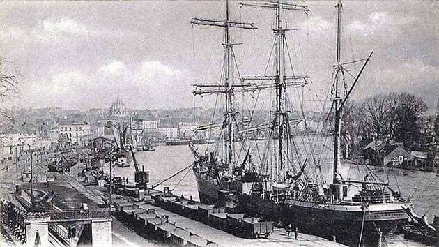
Nantes Port at the end of the 19th century (Quai de la Fosse) Le Coat Collection
A living memory of French Cape Horners
The term “Cape Horners” (or cap‑horniers) refers both to the large merchant sailing ships and the sailors who rounded Cape Horn between roughly the mid‑19th century and the 1920s, sailing between Europe and ports in the Pacific Ocean. These three‑ or four‑masted steel windjammers faced extreme conditions—fierce winds, heavy seas and freezing cold—especially when they beat against the prevailing westerlies to pass from east to west around the Horn.
For over a century, until the 1920s, the Cape Horn route was one of the great arteries of global maritime trade: French sailing ships carried guano and nitrates from Chile and Peru, cereals from Australia and California, lumber from North America, metals and nickel ore, among many other cargoes. Long before steam power and the Panama Canal, these tall ships shaped the commercial networks of the era, leaving behind a legacy of courage and endurance.
The Cape Horn au Long Cours association and its roots
The association Cap Horn au Long Cours (CHLC) inherits its spirit from the International Association of Cape Horn Captains (AICH), originally the Amicale Internationale des capitaines au long cours Cap‑Horniers, now dissolved along with the last generation of sailing‑ship masters who created it. Carrying on that legacy, CHLC has as its mission “to preserve and make known the heritage of the Cape Horners,” whether ships, routes, trades or human itineraries.
To fulfill this mission, the association launched and maintains the website caphorniersfrancais.fr, entirely devoted to French merchant sailors who sailed around Cape Horn under sail. The site states a clear, ambitious goal: to document, in the longer term, all the voyages of all the French Cape‑Horn sailors on all the French merchant sailing ships that rounded the Horn.
Independent, volunteer‑based documentation work
The work behind Cap‑Horniers Français is carried out in a fully independent, volunteer‑led manner. The team gathers and cross‑checks multiple sources: shipping company archives, logbooks, crew lists, travel journals, family photographs, private letters, and corrections or additions sent by descendants of sailors.
The site’s authors openly acknowledge the “monumental” scope of the task and the fact that it will take years of work, inviting the public to contribute documents, personal memories, or any corrections to existing entries. This participatory approach turns the project into a genuinely collaborative maritime‑history endeavor, where families, local historians and enthusiasts progressively enrich a unique documentary database.
Ships, voyages, crews: a growing corpus of documentation
One of the site’s main strengths is its effort to reconstruct, vessel by vessel and voyage by voyage, the itineraries and the lists of mariners aboard. The stated aim is to move Cape Horners beyond being anonymous silhouettes in old photographs and to see them as individual men, identifiable by name and placed back in the context of their long‑distance campaigns.
The site also highlights narratives and first‑hand accounts, such as the story of Captain Abel Guillou of the three‑masted steel ship Bretagne, wrecked at Cape Horn in August 1900 after two and a half months of battling the elements, with the crew later rescued by the British four‑masted windjammer Maxwell. These stories give concrete flesh to the dangers of the Cape Horn route and illustrate the values of courage, resilience and solidarity that the association wishes to transmit as part of the Cape‑Horners’ heritage.
Getting Cape Horners out of the museums
CHLC does not limit itself to an online database; it also seeks “to get Cape Horners out of museums” by bringing their stories directly to the public through conferences, temporary exhibitions, and various events held across France. These outreach activities rely on the association’s research to tell the history of long‑distance sailors beyond the display of objects, placing the human dimension—words, experiences and personal trajectories—back at the heart of the narrative.
This itinerant mediation helps reconnect port cities and maritime regions with their Cape‑Horn sailing heritage, especially in the towns and ports that played a significant role in the sail‑trade economy. It also offers descendants of sailors a space where they can rediscover traces of their ancestors and understand the concrete context of their voyages.
A major historiographical and heritage contribution
From a scholarly perspective, the work of Cap‑Horniers Français fills a gap between the “official” history of merchant shipping (statistics, fleet data, major trade routes) and the lived, often under‑documented history of crews at the individual level. By reconstructing voyages one by one and identifying the sailors, the association produces a fine‑grained micro‑history of sailing around Cape Horn.
This approach makes it possible to study recruitment networks, regional origins, the rhythm of voyages, long or short careers, wrecks and homecomings, and more broadly how the global economy of nitrates, cereals or timber translated into concrete human trajectories. It further provides a valuable resource for researchers in social history, maritime geography, port studies or maritime anthropology.
Cape Horn, a strategic node in global sail‑trade routes
To understand the association’s importance, it is essential to recall Cape Horn’s role in global maritime networks before the era of steam and the Panama Canal. From the late 15th century onward, and more intensively from the 19th century, powers seeking new maritime routes for spices, and later guano, nitrates and other raw materials, pushed their fleets south of the Americas.
Throughout the 19th and early 20th centuries, French Cape‑Horn windjammers regularly sailed between Europe and the Pacific, rounding Cape Horn twice a voyage in many cases. These routes were crucial for the nitrate and cereal trades, but they also demanded exceptional seamanship in the “Furious Fifties” and “Roaring Forties,” which explains the enduring prestige attached to Cape‑Horn sailors.
Nantes, a major ship‑owning port and Horn‑route hub
Within this story, Nantes occupies a special place as a major ship‑owning port and shipbuilding center on the Loire estuary. In the 19th century, shipyards around Nantes—including the Chantiers de la Loire and Dubigeon—built large steel sailing ships intended for long‑distance trade, including routes toward the Pacific and the Horn.
Nantes’ port landscape developed around the quays of the Loire, the activities of ship‑owners, river barge traffic, and large merchant vessels operating in an increasingly global economy. The presence of a Rue des Cap‑Horniers in Nantes symbolically underscores the city’s historic link with the sailors who departed on these extreme voyages.
The research carried out by Cap‑Horniers Français helps reconnect these port‑city realities with individual lives: many of the Cape‑Horn sailors, officers and captains featured on the site were from Nantes, Loire‑Atlantique, or other Atlantic ports, their careers scattered across registers, logbooks, and family testimonies that the association brings to light.
Saint‑Nazaire, an oceangoing gateway to the Horn
With the rise of the Port of Saint‑Nazaire in the middle of the 19th century under the Second Empire, the Loire estuary gained a modern oceangoing outport that gradually expanded and complemented the facilities further upstream. Created in 1856, Saint‑Nazaire became a key element of the greater Nantes–Saint‑Nazaire maritime port, featuring docks, dry docks, and later major shipyards.
Although Saint‑Nazaire is now best known for large‑scale shipbuilding, including cruise liners, its origins lie in a broader maritime and long‑distance economy, including the transit and outfitting of sailing ships bound for the Atlantic and the Pacific. At the height of the sail‑ship era, the Nantes–Saint‑Nazaire port complex formed one of France’s main gateways toward the South Atlantic, the Pacific, and therefore the Cape Horn route.
The work of Cap‑Horniers Français—by documenting ship by ship the campaigns to the Pacific—helps highlight this dimension: one can follow vessels built or owned in the region, crews recruited from coastal villages along the Loire, and the long journeys that ultimately led them to round Cape Horn.
A resource for researchers, institutions and families
The site is freely accessible and serves as a premier‑quality resource for historians, students, maritime museums, but also for genealogists and families seeking to trace an ancestor’s seafaring career. The fine‑grained level of information—ship names, campaign dates, itineraries, onboard narratives, testimonies—allows for both detailed and cross‑cutting kinds of research.
By making this corpus available, Cap‑Horniers Français also contributes to the valorization of maritime heritage for local authorities, ports, and memory‑related sites, which can draw on the data for exhibitions, urban routes, commemorations, or educational projects. In doing so, the association positions itself as a bridge between archives, territories and the wider public.
A call for contributions and the future of the Cape‑Horn legacy
With full awareness of the immensity of the task, the association emphasizes that this work is evolving and incomplete, inviting anyone who possesses documents, photos, notebooks, crew lists, or family stories to contact them and help enrich and correct the published information. This openness underlines the collective nature of the project: the history of Cape Horners is no longer reserved for specialists alone, but becomes a shared memory to which everyone can contribute.
At a time when commercial sailing has vanished before the rise of mechanical propulsion, this independent research stands as a bulwark against the forgetting of a maritime world now gone, yet one that has shaped French port cities, estates and coastal cultures from Nantes and Saint‑Nazaire to the distant shores of the Pacific. By rigorously documenting Cape‑Horn sailing ships and their crews, Cap‑Horniers Français provides an irreplaceable tool for understanding this history and transmitting it to future generations.