Law 26.639, also know as Ley de Glaciares and enacted in 2010, established in Argentina the Minimum Budgets Regime for the Preservation of Glaciers and the Periglacial Environment, legally cementing the idea that glaciers are strategic freshwater reserves and public goods. Starting in 2025–2026, the national government pushed forward a project for a comprehensive modification of this norm (File 0161-PE-2025), which obtained half-sanction in the Senate and approval from the Chamber of Deputies, generating strong political and social conflict.
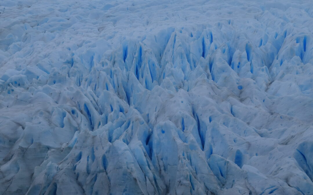
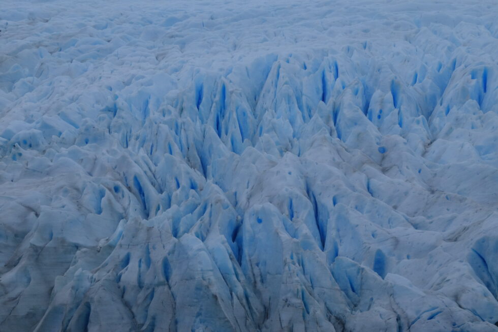
Karukinka Expedition (Fouque Glacier, 2025)
This article outlines the core content of the existing law, the main adopted modifications, the role of the provinces, as well as the social mobilizations and the interventions of Indigenous peoples—notably the Selk'nam jurist Antonela Guevara—who denounce the potential impacts of this reform (risks to water, ecosystems, and territorial rights).
Table of Contents
Law 26.639 (2010): content and scope
Purpose and principles
Article 1 of Law 26.639 sets the objective of establishing minimum budgets for the protection of glaciers and the periglacial environment, recognizing them as strategic reserves of water resources for human consumption, agriculture, watershed recharge, biodiversity protection, scientific research, and tourism. Glaciers are explicitly declared public goods.
The Library of Congress highlights that this law falls under the framework of Article 41 of the National Constitution (right to a healthy environment, national minimum budgets) and the General Environmental Law 25.675, which enshrines the principles of prevention, precaution, and non-regression.
Definitions: glacier and periglacial environment
Article 2 defines a glacier as any perennial ice mass, stable or slowly flowing, formed by the recrystallization of snow, regardless of its shape, dimension, or state of conservation; this includes rocky detrital materials and internal or superficial watercourses.
The periglacial environment is defined, in high mountains, as the area of frozen soils that acts as a water regulator, and in medium and low mountains, as the area with ice-saturated soils that plays the same regulatory role. These very broad definitions extend the scope of protection to forms of ice and frozen soils that go beyond just large visible glaciers.
National Glacier Inventory of Argentina (ING)
Articles 3 and 4 create the National Glacier Inventory, entrusted to the Argentine Institute of Nivology, Glaciology and Environmental Sciences (IANIGLA-CONICET), tasked with identifying all glaciers and periglacial landforms acting as water reserves, including their location, surface area, typology, and the variables necessary for their protection and monitoring.
The Legislative Dossier of the Library of Congress notes that Decree 207/2011 specified the organization of the ING by major glaciological regions (Desert, Central, Northern and Southern Patagonian Andes, Tierra del Fuego, and South Atlantic Islands) and mandated an update at least every five years.
Prohibited activities
Among its most important provisions, the law prohibits certain activities in glaciers and the periglacial environment, particularly:
mining and hydrocarbon exploration and exploitation;
the installation of industries;
the construction of works or infrastructure that could alter the natural dynamics of the ice or water quality (except for scientific research);
the storage or handling of contaminating or hazardous substances.
Any activity that may significantly affect these environments must be subject to a prior environmental impact assessment, in accordance with the General Environmental Law.
The 2025–2026 reform project: objectives and core modifications
Political context and stated objectives
In December 2025, the national executive branch submitted to the Senate Expediente 0161-PE-2025, aiming to amend Law 26.639, arguing the need to correct "interpretative flaws," lift legal uncertainties, and facilitate investments, particularly in mining. According to an analysis by Infobae, the executive presents the reform as a way to strengthen "environmental federalism" by giving provinces a greater role in managing their resources.
The project obtained 40 votes out of 72 in the Senate (40 in favor, 31 against, 1 abstention), with the support of part of the Radical Civic Union, Pro, and Peronist senators from mining provinces, before being passed to the Chamber of Deputies. In the lower house, the reform was ultimately approved by 137 votes in favor, 111 against, and 3 abstentions, and then sent to the executive for promulgation.
Redefinition of the inventory: "that act as reserves"
One of the most significant changes concerns Article 3 of the law, relating to the National Glacier Inventory. The new text, as described by the newspaper Ámbito, now stipulates that the ING will inventory glaciers and periglacial areas that "act as strategic reserves of water resources," instead of those that "fulfill the functions" of a reserve.
This substitution seems minor lexically, but the Library of Congress Dossier points out that it contributes to a re-definition of the extent of protected areas, by conditioning protection on the demonstration of an effective hydrological function rather than the mere presence of perennial ice. Provincial authorities are called upon to play a central role in this assessment.
Precautionary principle and possibility of subsequent exclusion
The reform introduces an Article 3 bis, which specifies, according to the text analyzed by Ámbito, that:
all glaciers and periglacial areas registered in the inventory will be considered part of the protected object until the competent authority verifies the non-existence of the hydrological functions defined in Article 1;
further on, it stipulates that when it is determined, based on technical-scientific studies, that a glacier or periglacial area "does not fulfill the intended functions," it may be considered excluded from the protected object.
We thus shift from a broad presumption of protection (any perennial ice mass in a periglacial environment) to a logic where the Inventory becomes a filtering tool, with the possibility of declassifying glacial units based on specific analyses.
Terminology: from "periglacial environment" to "periglacial landforms"
Several terminological modifications replace the expression "periglacial environment" with "periglacial landforms" (geoformas periglaciares) in the articles relating to the inventory and the competencies of authorities. For critics, this semantic substitution tends to fragment the object of protection (from the environment as a system to isolated landforms), which could reduce the territorial scope of the law.
Provincial competencies and the role of IANIGLA
The reform strengthens the mention of provincial authorities as "competent authorities," tasked with identifying, based on technical-scientific evidence, which glaciers and periglacial areas located in their territory fulfill certain hydrological functions. Where the previous version spoke of "sharing" information with IANIGLA, the new drafting replaces it with "notifying" the institute of the recorded ice bodies.
The Library of Congress Dossier indicates that these changes are at the heart of the debate on environmental non-regression: the fear is that provincial authorities subject to strong economic pressures might reclassify areas based on their hydrological functions, thereby reducing the extent of the protection regime.
Prohibited activities and environmental assessments
Article 6 (prohibited activities) is also amended. The new text maintains the catalog of prohibited activities (activities that "relevantly" alter the natural condition or hydrological functions, destruction, displacement, interference with ice advance, etc.), but now specifies that the severity of the alteration must be assessed "in the terms of Article 27 of the General Environmental Law 25.675," thus referring back to the environmental framework legislation.
The text confirms the obligation to subject any activity in glaciers and periglacial areas to environmental impact assessments, guaranteeing an instance of citizen participation in accordance with Articles 19 to 21 of the General Environmental Law. However, opponents argue that the reduction of the protected area makes these guarantees less effective.
Social mobilizations and territorial resistance
National mobilizations: "The Glacier Law is not to be touched"
The prospect of reforming Law 26.639 triggered a wave of mobilizations starting in late 2025, peaking during the debates in the Senate (February 2026) and the Chamber of Deputies (April 2026). Infobae and other Argentine media outlets reported massive demonstrations in Buenos Aires in front of the Congress, convened under the slogan "La Ley de Glaciares no se toca" ("The Glacier Law is not to be touched"), with a torchlight march and an artistic festival lasting until midnight.
Environmental organizations and citizen assemblies gathered for this day assert that the proposed changes endanger 7 million people and 36 watersheds deemed vital for various regions of the country, by opening the door to extractive activities in currently protected areas. Demonstrators insist that the reform "allows intervention in areas that the current law protects" and that it compromises access to water as a fundamental right.
Territorial mobilizations: the case of El Calafate
In El Calafate (Santa Cruz province), at the foot of the Perito Moreno glacier, mobilizations have followed one another: in February 2026, a new demonstration "in defense of the glaciers" was held simultaneously with the Senate vote, under the slogan "The Glacier Law is Not to Be Touched." According to local media Ahora Calafate, this was the fourth mobilization of the year 2026 in the city, with a march starting from Perito Moreno Square to the governor's official residence.
Organizers emphasize that "water and glaciers are non-negotiable" and announced further actions if the reform is approved, directly linking glacier protection to water security and the regional tourism development model.
Intervention of Indigenous peoples and the role of Antonela Guevara
A Selk'nam voice in the national debate
In this context, the jurist Antonela Guevara, lawyer for the Selk'nam community and a leading figure in the plurinational environmental campaign, became one of the most visible Indigenous voices in the debate over the Glacier Law. In an interview with Radio Provincia relayed by the media outlet Tarde pero Seguro, she stated that the modification of the law was decided "without social license and with a public hearing that was a farce," calling it "anti-regulatory" and "lacking real democracy."
Guevara denounces that more than 100,000 people who participated in the expanded consultation process were "silenced" and that the discussion is presented as purely technical, when "we are talking about water, about the present and future of life." She points out that the Selk'nam people have occupied the territory for over 10,000 years and asserts that the reform is intimately linked to commitments made by the government to the IMF and multinational corporations, rather than to the interest of citizens.
Glaciers, water, and prolonged genocide
In statements relayed on social media by Argentine Indigenous organizations, Antonela Guevara describes the modification of the law as a "new genocide" that threatens not only the glaciers but also the wetlands (humedales) and watersheds upon which Indigenous communities depend. She draws a connection between the current reform and local precedents, such as the salmon farming project in Tierra del Fuego, highlighting a similar logic of decisions made without genuine consultation and last-minute modifications.
Presenting herself as an "Indigenous woman and member of a people who have resisted for centuries," she insists that her participation in the national debate is not motivated by partisan affiliation, but by the defense of future generations, water, and ancestral territories.
Denounced potential impacts
Reduction of protected areas and risk of environmental regression
Analyses by the Library of Congress and Argentine economic media converge in stating that the reform "redefines the extent of protected spaces" by conditioning protection to glaciers and periglacial areas that demonstrate an effective hydrological function. This approach is perceived by many jurists and environmentalists as potentially regressive, contradicting the principle of non-regression enshrined in Argentine environmental doctrine.
Specifically, the fear is that small glaciers, buried ice zones, or frozen soils that play a water storage and regulation role—but are difficult to characterize—could be excluded from the specific regime, paving the way for mining, energy, or infrastructure projects.
Mining pressure and socio-environmental conflicts
Articles from La Nación and Infobae recall that one of the explicit goals of the reform is to "enable mining investments," particularly in copper and lithium, in areas hitherto considered protected by Law 26.639. The Andean provinces with a strong extractive focus (San Juan, Catamarca, Jujuy, Mendoza, etc.) occupy a central place in this debate, with some of their representatives having voted in favor of the reform in the Senate.
Mobilized organizations denounce that by weakening the perimeter of protected spaces, the reform risks intensifying existing socio-environmental conflicts surrounding large high-mountain mining projects, by reducing the legal instruments available to local communities and municipalities opposing them.
Threats to water and wetlands (humedales)
Actors in the "La Ley de Glaciares no se toca" campaign insist that the discussion is not just about visible ice, but the entire water cycle: aquifers, wetlands, catchments, and seasonal regulation. By limiting protection to glaciers and periglacial areas whose hydrological function is proven, the reform could, according to them, neglect complex hydrological systems whose contribution is not immediately quantifiable.
Antonela Guevara and other Indigenous spokespersons emphasize that these environments are intimately linked to the survival of their communities and their cosmologies, meaning that their alteration amounts to a new form of territorial and cultural violence.
CÁMARA DE DIPUTADOS DE LA NACIÓN ARGENTINA. Proyecto de modificación de la Ley 26.639: tratamiento parlamentario 2025–2026 [online]. Buenos Aires: HCDN, 2026 https://www.hcdn.gob.ar/
SENADO DE LA NACIÓN ARGENTINA. Dictamen y votación del proyecto de reforma de la Ley de Glaciares [online]. Buenos Aires: Senado de la Nación, 2026 https://www.senado.gob.ar/
TARDE PERO SEGURO. Antonela Guevara: “La modificación de la Ley de Glaciares se hizo sin licencia social” [online]. Argentina, April 8, 2026. https://tardeperoseguro.com.ar/?p=52515
ORIGINARIOS.AR. Antonela Guevara: intervenciones sobre la reforma de la Ley de Glaciares [online]. Argentine, s. d. https://originarios.ar/
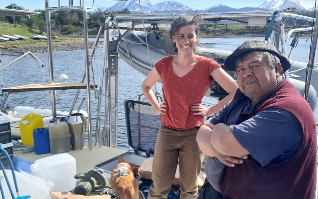
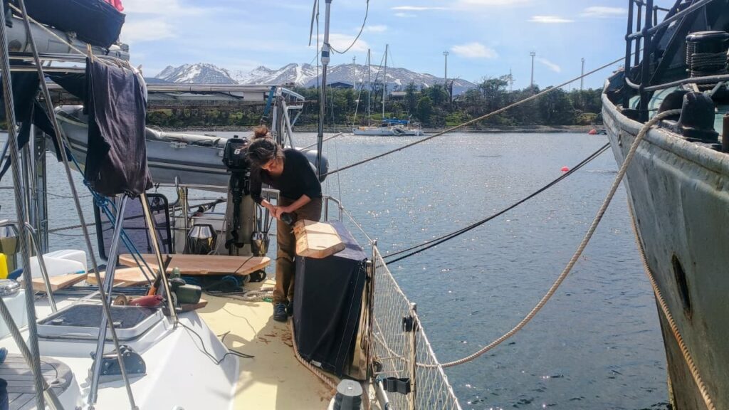
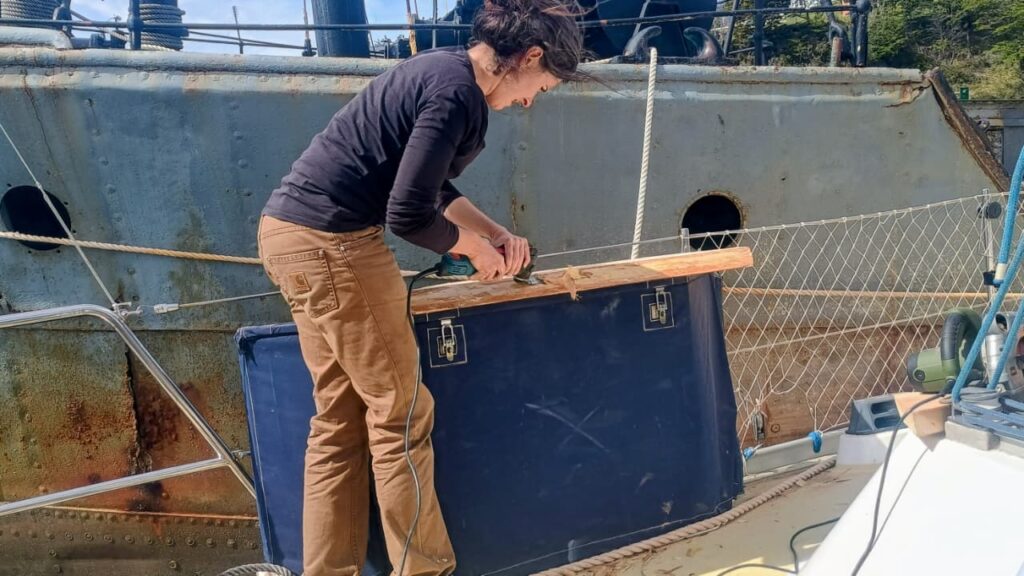
On Monday, October 27, the Milagro resonated with the sound of coigüe wood and tools. With José, crew member and godparent of the boat, we dedicated the day to a traditional woodworking session to craft two new work surfaces from coigüe wood. These new fittings, now installed at the stern of the sailing vessel, will be used to clean fish and lift nets outside, in perfect harmony with the sea and the wind. On board, the scent of freshly cut wood mingled with that of changing tides. The finishing touches were done with an axe, a vibrating saw, and finally a grinder.
Heritage of the Yagan people
Among the Yagans, people of the channels of Tierra del Fuego, woodworking holds an essential place. Originating from a culture intimately linked to water and cold, the Yagans shape wood for everything: canoes, tools, shelters. Their know-how is based on a keen sense of the material, capable of transforming a wet log into a light boat or a rough plank into a durable work surface. By reviving these ancestral gestures, although supplemented by modern tools, we pay homage to this millenary maritime culture, which saw in every piece of wood a fragment of the landscape, a trace of the link between humans and nature.
Lauriane and José aboard Milagro, with a first coigüe wood work surface on the starboard aft balcony.
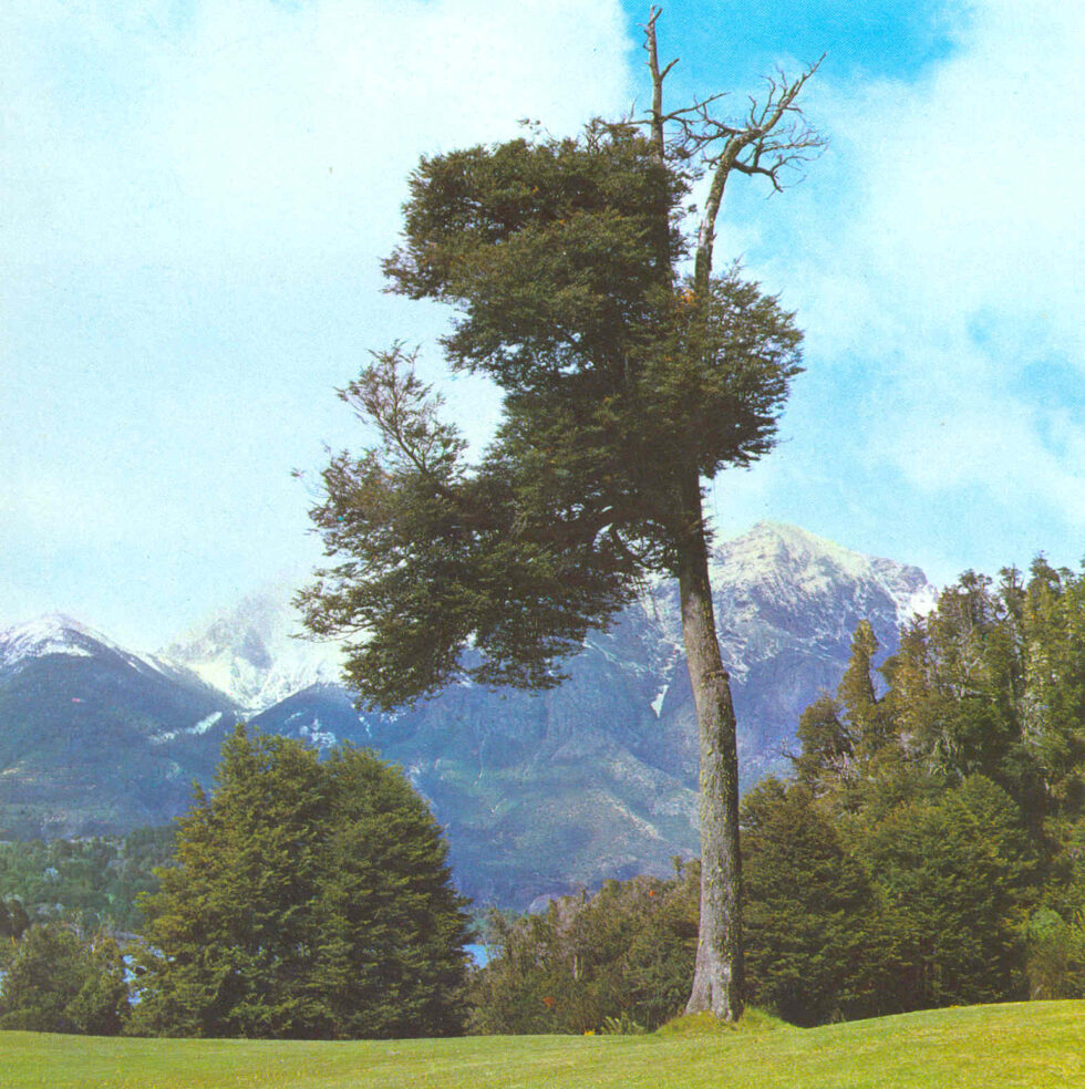
Coigüe wood, the strength of Southern Chile
The coigüe (Nothofagus dombeyi) is a emblematic tree of the temperate forests of southern Chile and Patagonia. Its wood, dense and strong, is distinguished by a clear and warm tint, perfect for marine works. It is a species that withstands moisture well and ages gracefully, developing a soft patina over the seasons. Working with coigüe means handling a living material, rooted in the same earth and winds that the Milagro sails through. This noble wood, over 60 years old in the case of what we used, was shaped here in the traditional way so that the boat continues its journey respecting the traditions and nature surrounding it.
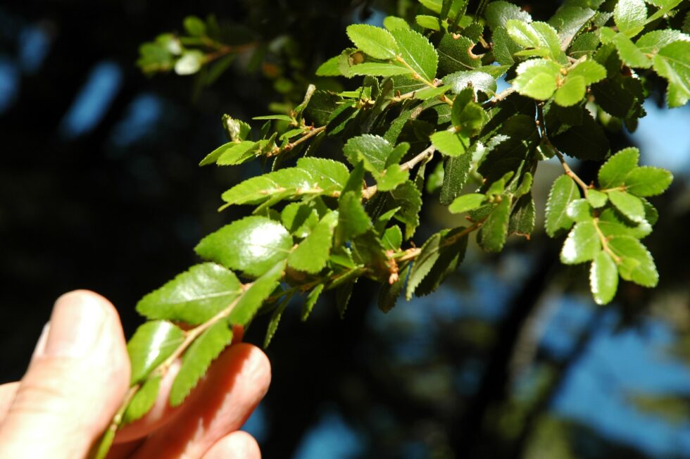
Coigüe leaves (Valerio Pillar de Porto Alegre, Brazil — DSC_7172.JPGUploaded by pixeltoo, CC BY-SA 2.0, https://commons.wikimedia.org/w/index.php?curid=10393830)
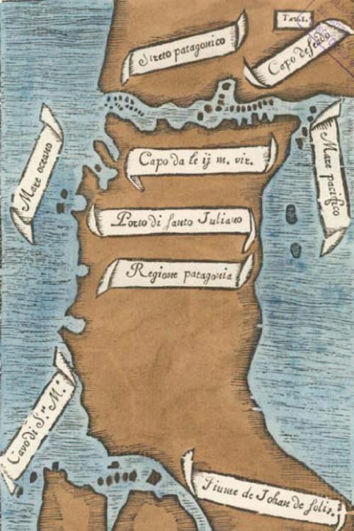
On 21 October 1520, five ships that had left Seville a year earlier entered an unknown channel. Thirty‑eight days later, they reached an ocean Europeans had never sailed before : the Strait of Magellan. Magellan named the passage Estrecho de Todos los Santos. Only after his death in the Philippines did Charles V give it the name it bears today.
The Selk’nam called it Hatitelen — or Atelili in other transcriptions. They lived on the southern shore of the strait for over ten thousand years. These names re‑emerge today through toponymic work carried out since 2017, drawing on nineteenth‑century French archives.
Table des matières
1. Geography
The strait links the Atlantic and Pacific Oceans over 570 kilometres, from Dungeness Point to the Evangelistas islets. Its width ranges from 2 kilometres at its narrowest constriction, near Carlos III Island, to 32 kilometres in its broadest sections. Depths vary from about 28 metres around Magdalena Island to more than 1,000 metres off Cooper Key.
This submarine relief is not random. Late Cretaceous fractures first opened corridors in the Earth’s crust. Pleistocene glaciers then deepened, widened and multiplied these channels. The result is the maze of fjords and passages that still defines Magellanic navigation today.
2. Navigation
Westerly winds dominate for much of the year. Williwaws — katabatic squalls that tumble down the slopes without warning, a Kawésqar word — can exceed 100 knots. Fog, heavy precipitation and visibility reduced to just a few cables make the strait a demanding passage.
Antonio Pigafetta, chronicler of Magellan’s voyage, notes “very safe harbours, excellent water, wood, fish”. His account opened two centuries of gradual hydrographic work.
Map of the Strait by Antonio Pigafetta (Ferdinand Magellan expedition, 1520)
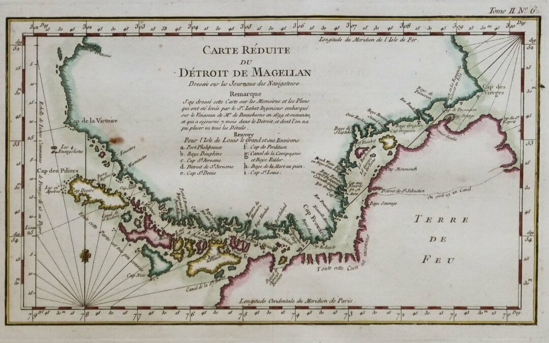
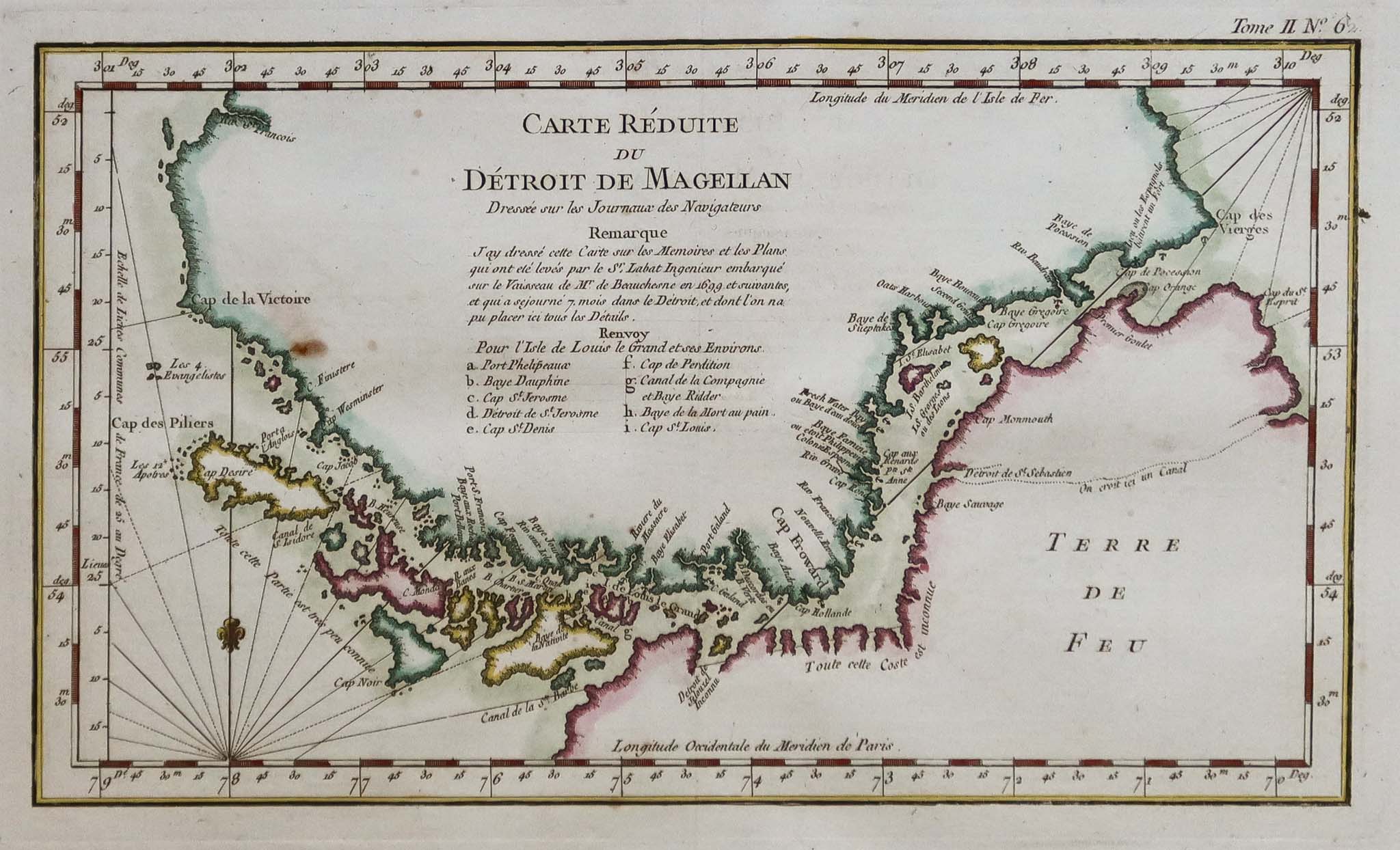
In 1698–1701, the expedition of Jacques Gouin de Beauchesne — commissioned by Louis XIV for the Royal South Sea Company and outfitted by Saint‑Malo shipowner Noël Danycan de L’Épine — produced the most accurate French document on Magellanic geography of its time. The manuscript was kept secret for years to protect French colonial ambitions in the region.
Map of the Strait of Magellan (1699) based on observations from the French Beauchesne expedition
Since 1978, Chilean maritime authorities (DIRECTEMAR) have required all commercial vessels to embark a Chilean pilot at Bahía Posesión, at the eastern entrance.
The explorer initially named the passage "Estrecho de Todos los Santos" ("Strait of All Saints") in reference to the religious feast celebrated on the day of its discovery. It was only after his death in the Philippines that Charles V, King of Spain, renamed the strait in honor of its discoverer.
3. First inhabitants
Three peoples shared these shores long before 1520, each with a very different relationship to water and territory.
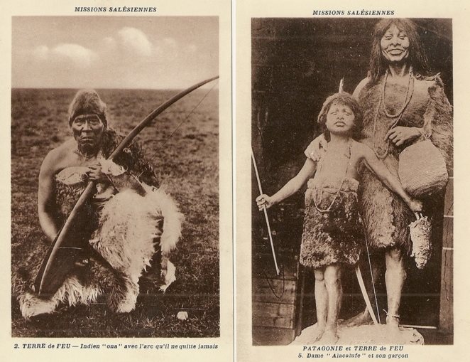
Salesian archive photos: a Selknam man with his bow, and a Kawésqar woman with her son
The Kawésqar had been travelling these channels in bark canoes for around 6,000 years, between the Gulf of Peñas and the strait. Fishing and hunting marine mammals, they moved in small family groups without permanent settlements. Kawésqar simply means “human being”. Chilean Law 19.253 has recognised them since 1993; the 2017 census records 3,448 people identifying as Kawésqar.
The Aónikenk, the southern branch of the Tehuelche, hunted on foot across the continental steppe between the Santa Cruz River and the strait. Pigafetta, struck by their height — a head taller than Europeans of the time — coined the term Patagón, borrowed from the giant Pathoagon in a chivalric romance. This is how Patagonia got its name.
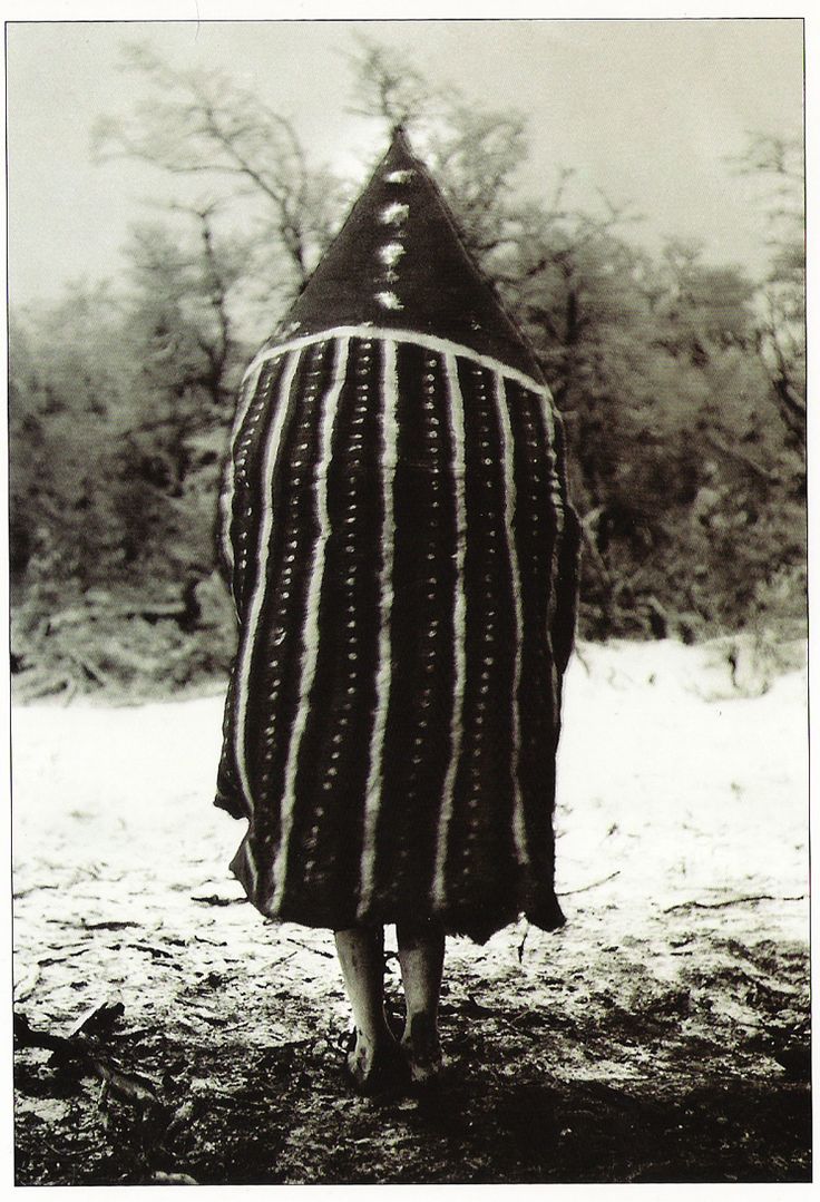
The Selk’nam reached the large island of Tierra del Fuego on foot, before the melting of the ice opened the strait. Their society, structured into lineages (haruwen) and seven exogamous “skies”, created one of the most complex initiation ceremonies in the Southern Hemisphere: the Hain. The shamans (xo’on) entered trance through song to communicate with the powers of the skies.
Tanu, one of the deities/spirits represented during the Hain, Selknam male initiation ritual; photo by Martin Gusinde
From the 1870s onwards, the arrival of sheep ranches triggered systematic extermination. Bounties were paid for the ears of Indigenous people killed. In 1896, ethnologist Martin Gusinde estimated the Selk’nam population at more than 3,000. By 1919, it had fallen to 279. Groups were captured and exhibited in European human zoos between 1878 and 1900.
Argentina officially recognized the Selknam in 1994, while Chile did so in 2023 through Law 21,606. The 2010 Argentinian census records 2,761 people identifying as Selknam, with over 294 living in Tierra del Fuego. In Chile, 1,144 people declared themselves Selknam in the 2017 census. The Kawésqar are recognized by Chilean Indigenous Law 19,253 (since 1993) and are organized into 14 Indigenous Communities. According to the 2017 Chilean census, 3,448 people declare themselves Kawésqar.
4. Biodiversity
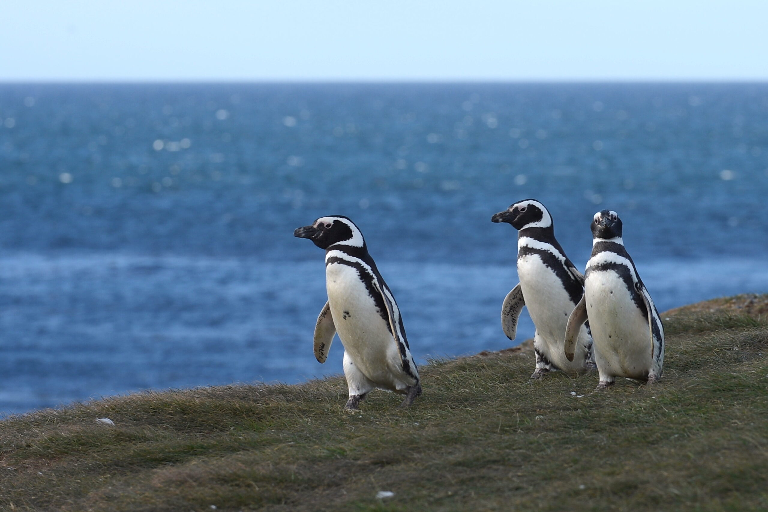
Some 32 kilometres north‑east of Punta Arenas, Magdalena Island is home to around 50,000 breeding pairs of Magellanic penguins (Spheniscus magellanicus). These birds — seen by Magellan himself in 1520, who mistook them for geese — can reach 76 centimetres in height.
Magellanic penguins on Magdalena Island (Magellan Strait, Magallanes province, Chile)
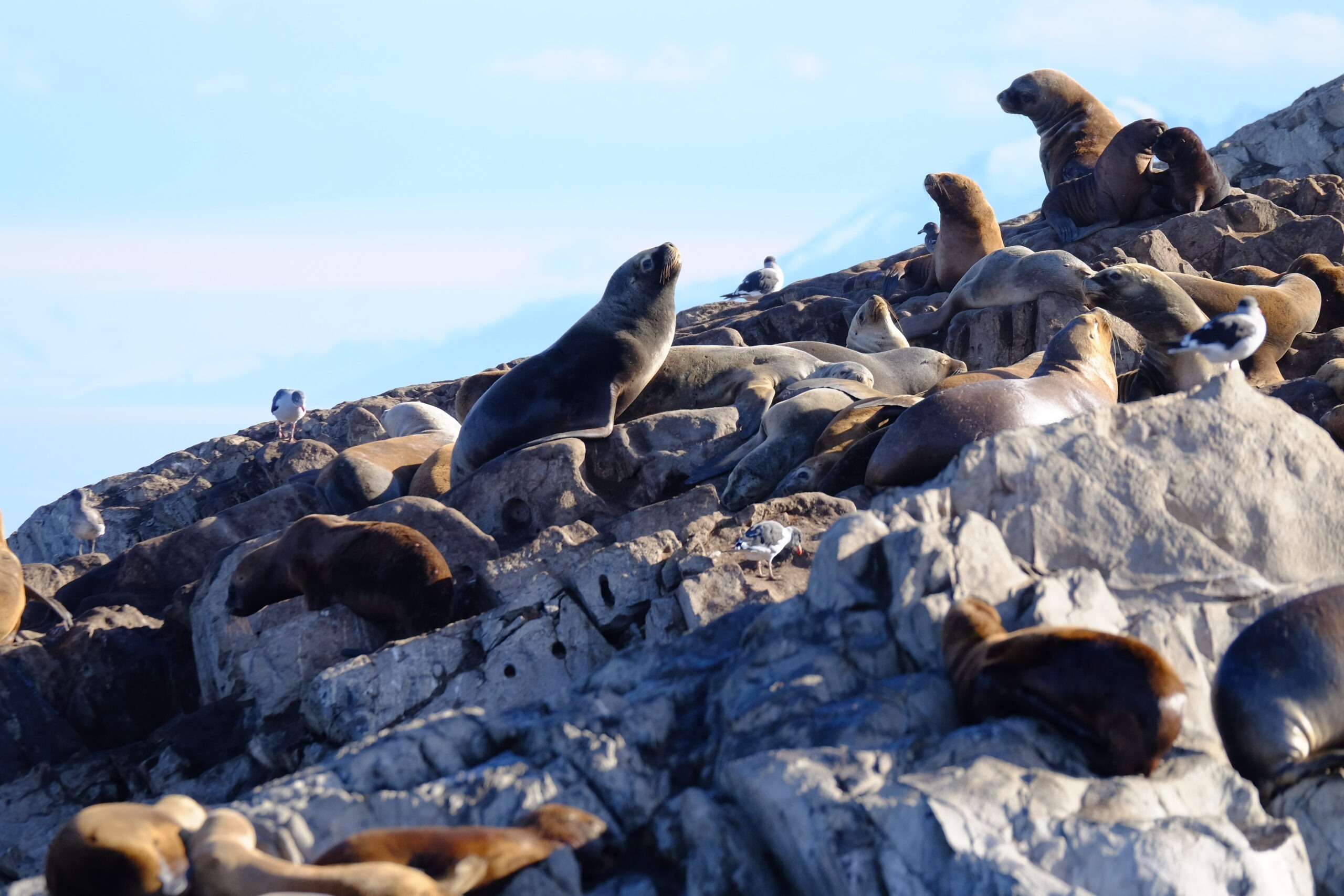
Further west, Francisco Coloane Marine Park, Chile’s first marine park, protects waters where humpback whales regularly winter. South American sea lions and southern elephant seals haul out on rocky islands. Imperial cormorants, black‑browed albatrosses, giant petrels and Andean condors patrol both shores.
Small fur seal colony, Patagonian channels, Chile
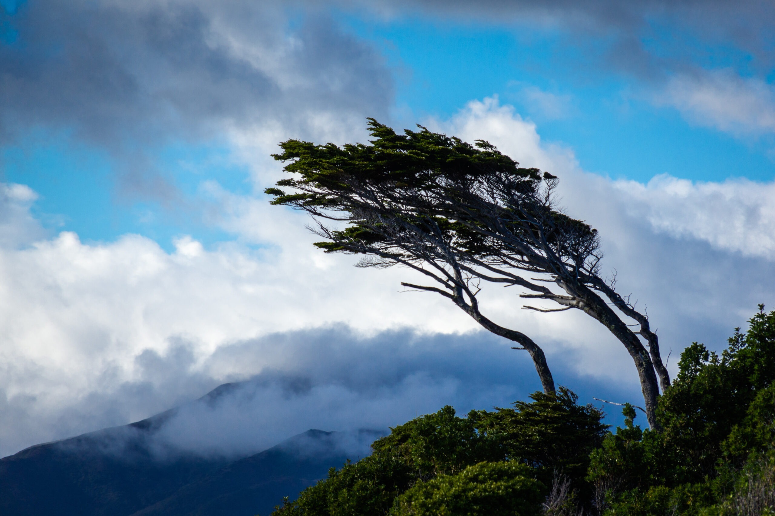
On land, sheltered slopes carry forests of Nothofagus — Magellanic coigüe, lenga and ñirre — sculpted by the wind into leaning silhouettes where they are most exposed. Between the trees, thick bryophyte carpets close the canopy at ground level. These ecosystems connect directly with those of the Cape Horn Biosphere Reserve to the south.
Patagonian beech bent by the wind, Estrecho de Magallanes, Chile
5. The strait today
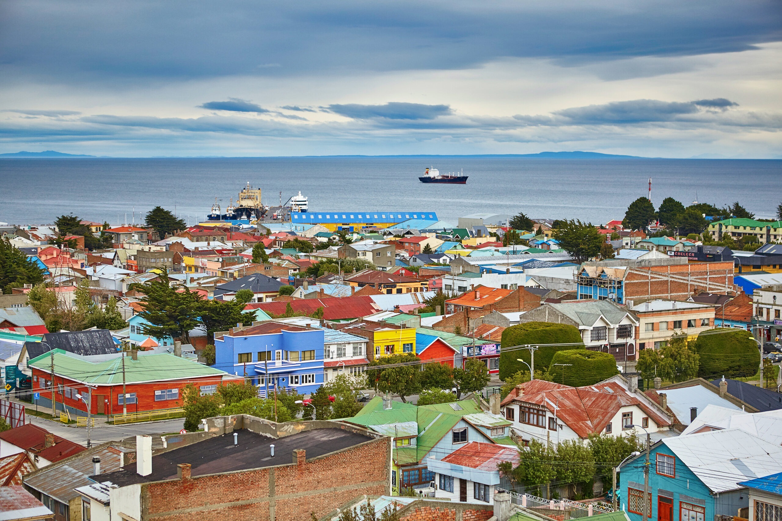
The opening of the Panama Canal in 1914 gradually diverted commercial traffic away from the strait. Since 2023, the trend has reversed. Prolonged drought limiting the canal’s capacity, geopolitical tensions and the canal’s unsuitability for ultra‑large vessels have revived the Magellanic route. The Chilean Navy reported a 25% increase in traffic in 2024, with projections of up to 70% growth over the full year. The route through the strait is 390 nautical miles longer, but accessible to any draught and free of locks.
View of Punta Arenas, a stopover for international maritime transit, Magallanes Province, Chile, South America
At the same time, the Magallanes region is developing a green hydrogen project based on the strait’s exceptional wind potential. Constant winds could theoretically generate seven times Chile’s current electrical capacity. The project remains controversial in its details, but it says something important about what this passage represents today: a strategic corridor once again, five centuries after Magellan
This specialization strengthens the region as a hub for international polar tourism, with infrastructure meeting International Association of Antarctic Tour Operators (IAATO) standards.
Bibliography
Pigafetta, A. (1522). Relazione del primo viaggio intorno al mondo. Critical edition: Dentrecasteaux, 1830.
Gouin de Beauchesne, J. (1701). Relation journalière d’un voyage fait en 1698, 1699, 1700 et 1701. Manuscript. Service Historique de la Défense, Vincennes.
Gusinde, M. (1931–1939). Die Feuerland-Indianer. 3 vols. Mödling bei Wien: Anthropos-Bibliothek.
Museo Chileno de Arte Precolombino. (2021). Cuaderno educativo — Pueblos originarios de Magallanes. Santiago: Museo Chileno de Arte Precolombino.
DIRECTEMAR. (2025). Generalidades del Estrecho de Magallanes. Dirección General del Territorio Marítimo y de Marina Mercante, Chile.
Armada de Chile. (2024). Maritime Traffic Statistics — Estrecho de Magallanes.
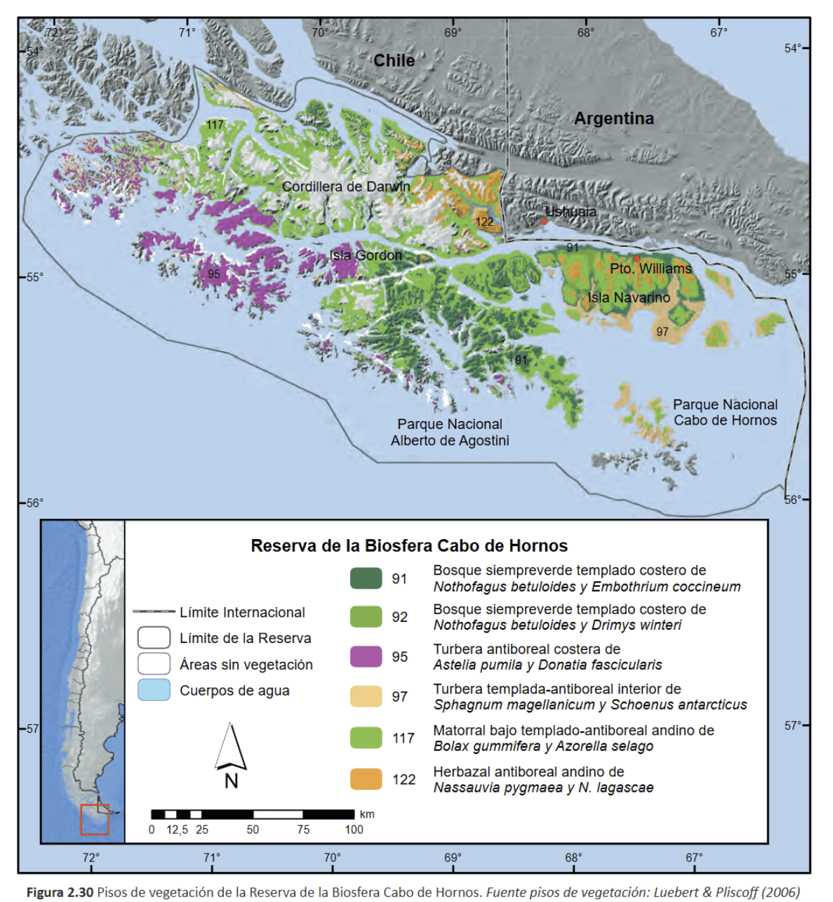
The Cabo de Hornos Biosphere Reserve (Cape Horn Nature Reserve), established in 2005, is one of the southernmost and largest protected areas in the world, covering more than 4,884,000 hectares of southern lands and waters. It contains unique terrestrial and marine ecosystems, pristine subantarctic forests, remarkable biodiversity—including over 5% of the world’s bryophyte diversity—and the populations of the Yaghan people, who maintain a millennia-old connection with these extreme landscapes.
Table des matières
The Cabo de Hornos Biosphere Reserve was included in UNESCO’s “Man and the Biosphere” program in June 2005, becoming both the southernmost and one of the largest biosphere reserves in South America. Spanning about 4,884,274 hectares, it comprises a terrestrial area of 1,917,238 ha and a marine area of 2,967,036 ha, integrating for the first time in Chile both marine and terrestrial ecosystems under a unified conservation status. The Alberto de Agostini and Cape Horn National Parks form the core protected area, where all infrastructure development is strictly prohibited.
1. Geography and zoning of the Cape Horn nature reserve
Geographically, the reserve extends across the Tierra del Fuego archipelago, between 54.1° S and 56.2° S latitude, and 66.1° W and 72.5° W longitude. It includes the Wollaston, Hermite, Navarino, and Hoste islands, as well as channels (including the Beagle Channel), fjords, and currents that form a landscape shaped by glaciations and tectonic activity. The UNESCO MAB Reserve zoning (Cabo de Hornos Biosphere Reserve, i.e., the southern Chilean marine reserve) is structured into three areas:
The core zone (Alberto de Agostini National Park including the Darwin Range, and Cape Horn National Park) is strictly protected.
The buffer zone, where light and sustainable activities are allowed.
The transition zone, including isolated villages like Puerto Williams and limited infrastructure under a sustainable development framework.
The reserve’s subantarctic forests are the southernmost on earth. Dominated by three Nothofagus species—N. pumilio, N. betuloides, and N. antarctica—they form both deciduous and evergreen stands, interspersed with peat bogs and alpine heaths. These forests are among the world’s rare examples of non-fragmented temperate forest. The organic-rich soils support vast carpets of bryophytes, typical of the cool, humid environment; these play a crucial role in the hydrological cycle and carbon sequestration.
2.2 Marine and coastal ecosystems
The marine component of the reserve centers around a complex network of fjords, channels, and underwater plateaus. The Humboldt current and the mixing of cold Pacific and Atlantic waters have fostered the development of kelp forests (Macrocystis pyrifera, Durvillaea antarctica) forming “underwater forests” that host diverse invertebrate fauna and fish communities. Intertidal habitats harbor macroalgae species and numerous endemic invertebrates, while the cold, oxygen-rich waters support populations of seals, sea lions, and several cetacean species.
3. Biological diversity and endemism: subantarctic biodiversity
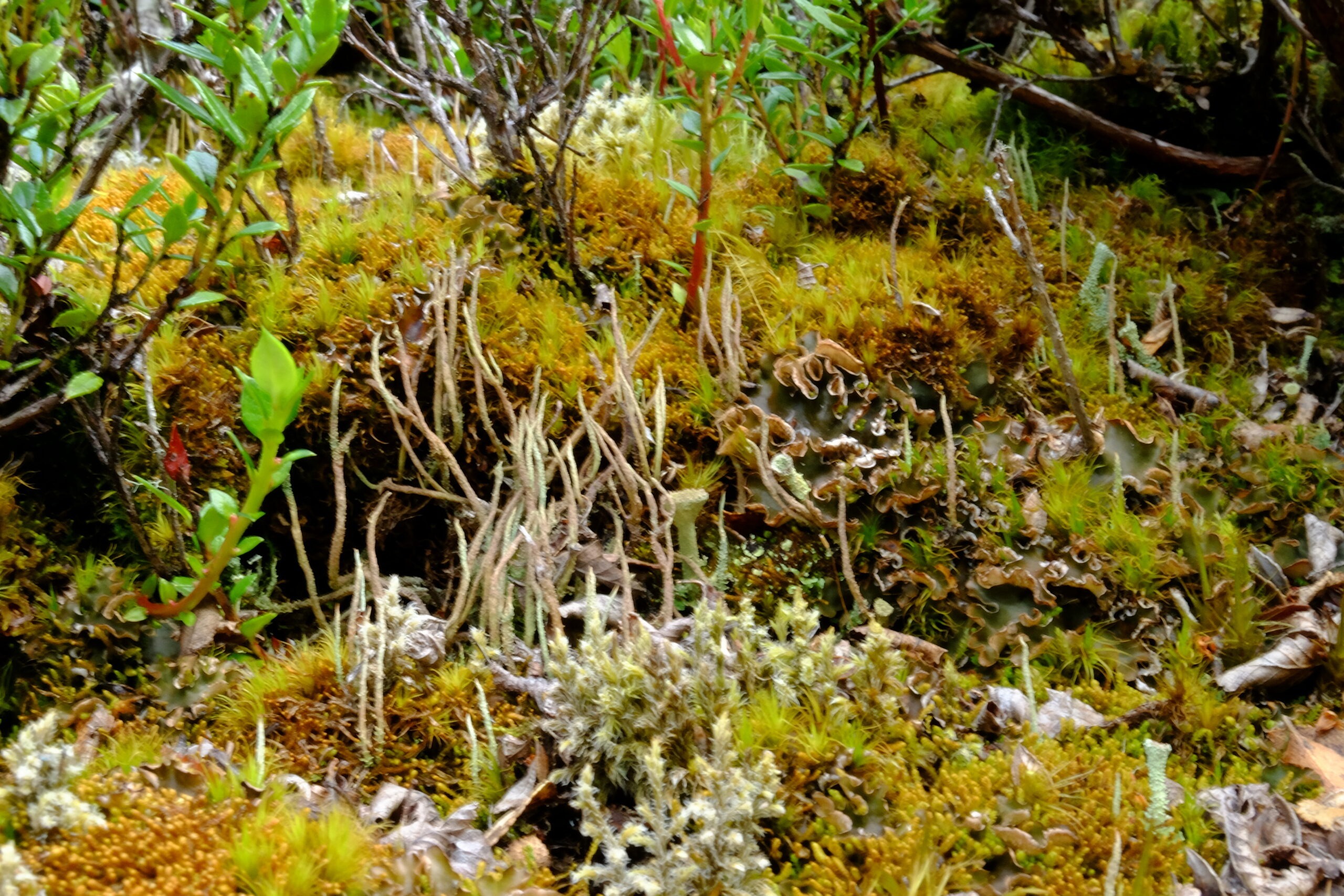
3.1 Bryophytes and lichens
With over 300 species of liverworts and 450 species of mosses, the reserve is a global hotspot for bryophytes, representing more than 5% of global diversity on less than 0.01% of the world’s land surface. These communities, described as “miniature forests,” serve as sentinels for assessing the impacts of climate change and rising UV radiation.
Example of bryophytes / miniature forest (mosses, liverworts, and lichens) from the Cape Horn Biosphere Reserve (MAB-UNESCO); Navarino Island, 2020 (c) Lauriane Lemasson.
3.2 Terrestrial and marine fauna
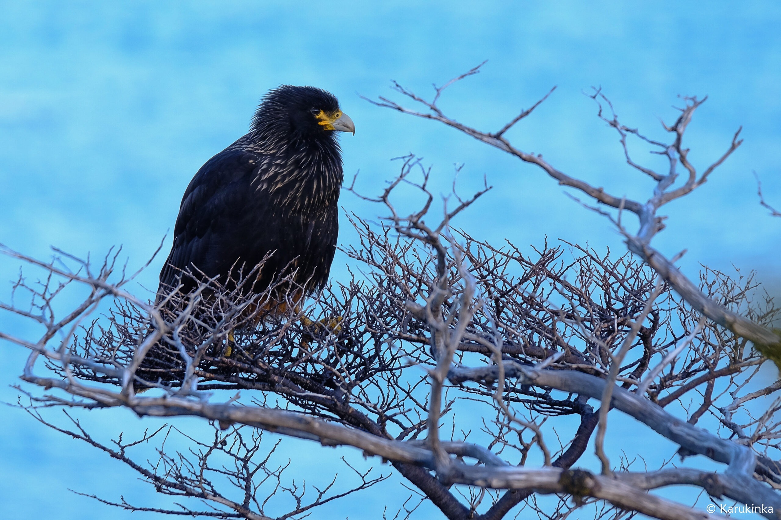
Terrestrial fauna include the southern river otter (Lontra provocax), the Magellanic woodpecker (Campephilus magellanicus), and other endemic birds. In the marine environment, the surrounding waters are home to black-browed albatross, giant petrels, Magellanic penguins, and stable populations of fur seals and leopard seals, highlighting the ecological importance of this protected area.
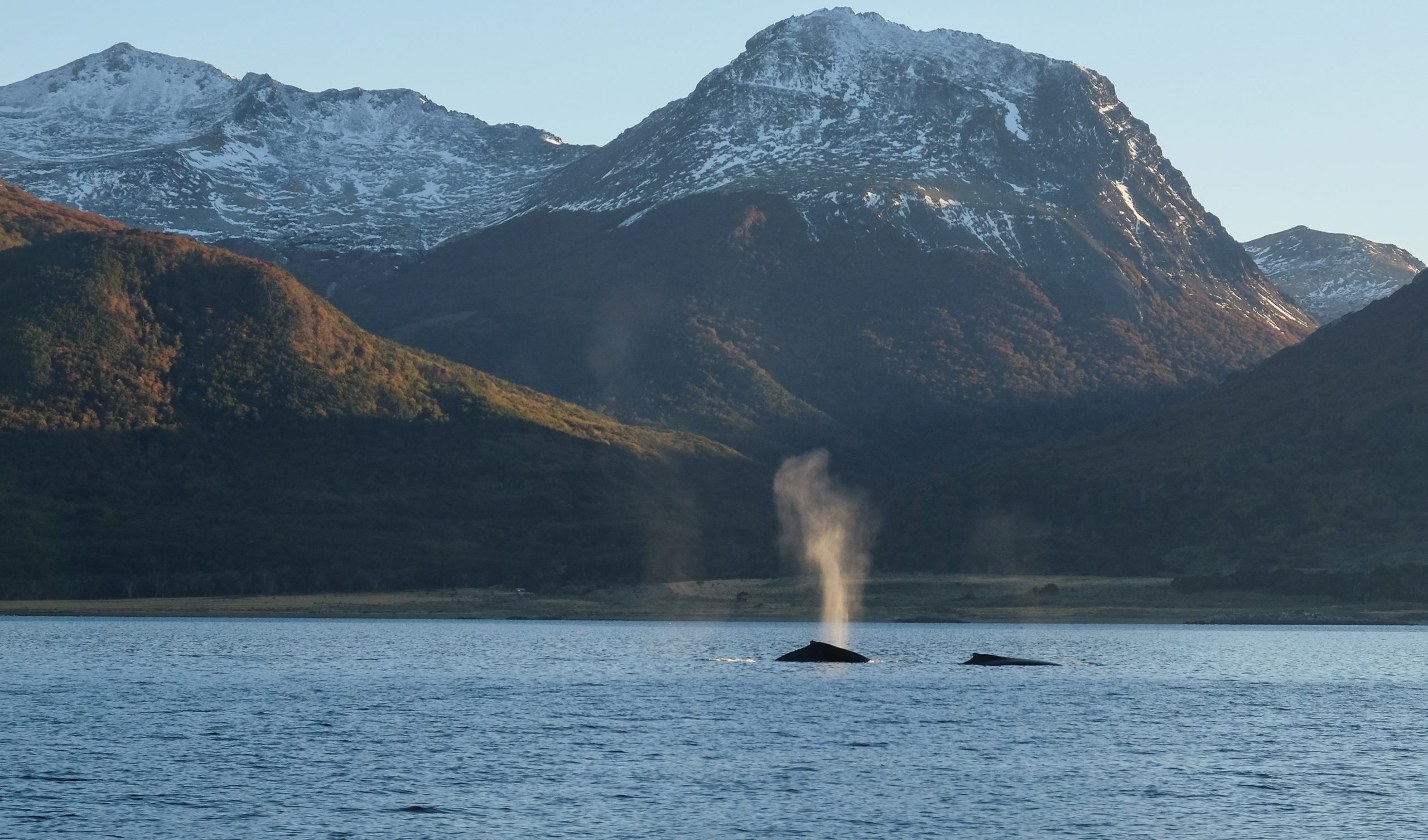
A black Carancho from Martial Bay (Cape Horn Reserve, April 10, 2025, during a sailing expedition at Cape Horn and in the Patagonian channels)Whales in the Beagle Channel during the 2018 expedition (Karukinka Association)
4. Biocultural dimension and Yaghan ethnology
The reserve is also a cultural sanctuary. The Yaghan, nomadic people of the southern channels, are the world’s southernmost indigenous group, with a presence dating back over 7,500 years, as evidenced by archaeological sites on Navarino Island. They continue to possess expert knowledge of canoe navigation and subantarctic ecology, and have actively participated in research within the reserve, particularly through the Omora Ethnobotanical Park near Puerto Williams. Their oral traditions, language, and knowledge of local flora and fauna are incorporated into educational and conservation programs. Ecotourism in Patagonia is also a key activity of the Omora initiative.
5. Governance and management
The reserve is managed by a board chaired by the regional governor, involving public agencies and local organizations. The scientific committee, coordinated by the Omora Park and the University of Magallanes, leads research, ecological monitoring, and participatory conservation efforts. In 2006, the reserve joined UNESCO’s Ibero-MAB network, strengthening transnational cooperation for research and training.
6. Threats and conservation challenges
Despite its isolation, the reserve faces several threats:
Uncontrolled tourism development, particularly southern cruises and increased traffic around Cape Horn, poses risks of pollution and disturbance to marine wildlife.
Intensive salmon farming in northern fjords introduces exotic species and degrades water quality. Salmon now breed in these waters, impacting native species such as the robalo.
The spread of introduced species such as the North American beaver and mink threatens riparian forests, streamside habitats, and shorebird nesting sites.
Long-term monitoring programs, such as the Omora initiative and Long-Term Ecological Research (LTER) stations, assess these pressures and propose adaptive measures. However, monitoring is hampered by the vastness of the reserve and its logistical challenges.
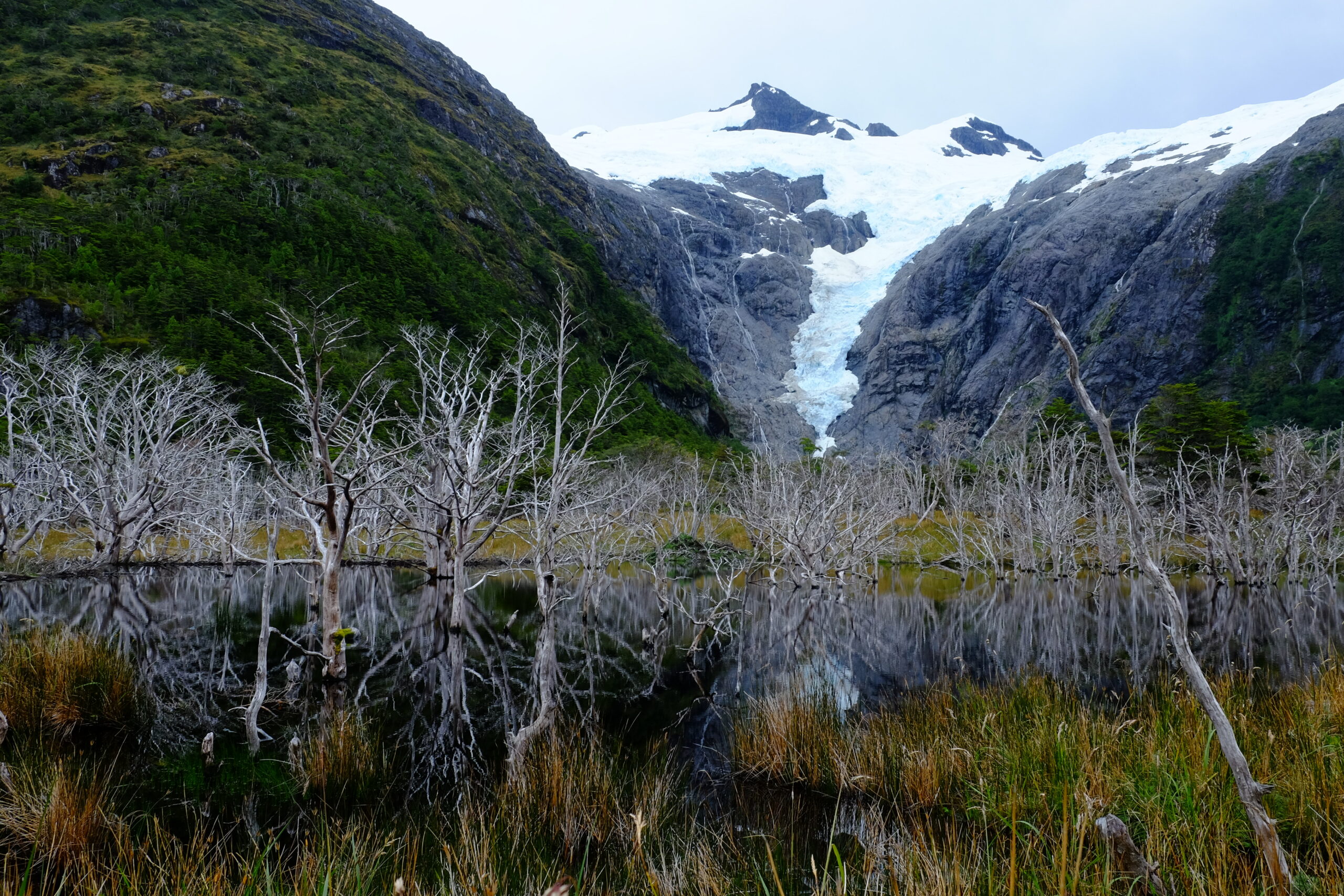
Lake created at the foot of a glacier by beavers, photographed during a sailing expedition in Patagonia (Beagle Channel, Hoste Island, Cape Horn Biosphere Reserve, Chile).
7. Research and education initiatives
7.1 Omora Ethnobotanical Park
Founded in 2000, the Omora Ethnobotanical Park is at the center of a transdisciplinary approach combining ecology, environmental philosophy, and “field philosophy” education. It offers educational trails, including “miniature forests,” to raise public awareness of bryophyte diversity and the link between biodiversity and Yaghan culture.
7.2 Cape Horn International Center (CHIC)
Inaugurated in 2020 in Puerto Williams, CHIC brings together researchers, artists, and indigenous communities to develop a model for biocultural conservation, technical training, and sustainable development. Its programs address the responses of biodiversity to climate change, the management of invasive species, and the formulation of public policy adapted to subantarctic zones.
The Cabo de Hornos Biosphere Reserve remains one of the rare refuges where harmonious coexistence between local inhabitants and ecosystems at the literal edge of the world is fully realized. Securing its future means strengthening participatory governance, managing invasive species, and supervising polar tourism under the banner of responsible ecotourism. Finally, the ongoing integration of Yaghan knowledge in research and education programs will ensure the preservation of both the biological and cultural heritage of this unique subantarctic sanctuary.
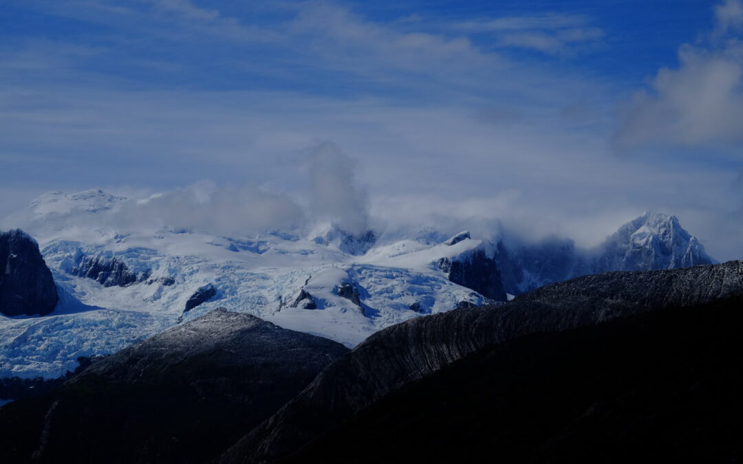
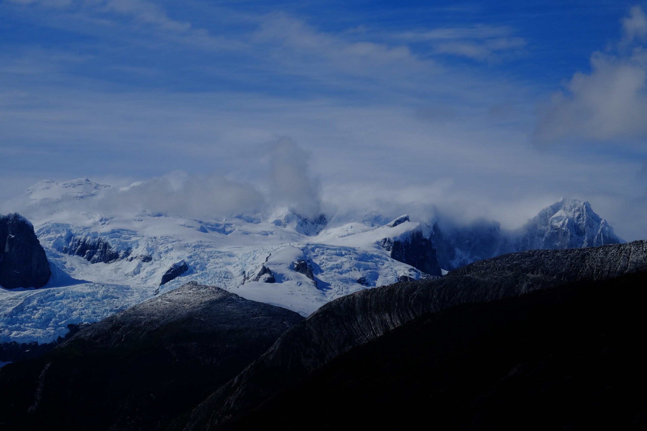
Pia Glacier, Patagonian Channels, Darwin Range, Cape Horn Biosphere Reserve, Magallanes, Chile, 2025
Bibliography
Rozzi, R. et al. (2006). Ten Principles for Biocultural Conservation at the Southern Tip of the Americas: The Cape Horn Biosphere Reserve. Ecology and Society, 11(1). https://www.ecologyandsociety.org/vol11/iss1/art43/
Rozzi, R. et al. (2004). Omora Ethnobotanical Park: A Model for Integrating Biocultural Conservation and Environmental Philosophy in the Cape Horn Biosphere Reserve. Environmental Ethics, 26(2), 131–169. https://doi.org/10.5840/enviroethics200426226
Mittermeier, R. A. et al. (2003). Hotspots: Earth’s Biologically Richest and Most Endangered Terrestrial Ecoregions. Conservation International. https://www.conservation.org
CONAF (Corporación Nacional Forestal). (2023). Reserva de la Biósfera Cabo de Hornos. Gobierno de Chile. https://www.chilebosque.cl
Cape Horn International Center (CHIC). (2021). CHIC Strategic Plan 2021–2026. Universidad de Magallanes. https://www.centrochic.cl
Anderson, C.B. et al. (2011). Exotic ecosystem engineers transform sub-Antarctic forest structure and function. Biological Invasions, 13, 545–561. https://doi.org/10.1007/s10530-010-9841-4
Anderson, C.B. et al. (2019). Cape Horn’s Lessons for Sustainability. Science Advances (UNESCO CHIC/UMAG). https://advances.sciencemag.org/
Rozzi, R. et al. (2010). La Reserva de Biósfera Cabo de Hornos: una propuesta educativa y de desarrollo sustentable en el extremo austral de Chile. Universidad de Magallanes. Disponible sur la bibliothèque CHIC.