The Darwin Cordillera represents one of the last wild frontiers of our planet, a mountain range of striking beauty yet formidable hostility, located at the far southwestern tip of Chilean Tierra del Fuego.
On 12 February 1834, Captain Robert FitzRoy names a mountain range at the southwestern tip of Chilean Tierra del Fuego in honour of Charles Darwin's 25th birthday. Darwin himself never sets foot there. He observes it from the deck of HMS Beagle, through the Beagle Channel, and senses — correctly — that it will resist exploration for a very long time.
Until 2011, when six French military alpinists completed its first integral crossing, the Darwin Cordillera remained one of the last "white rectangles" on world maps.
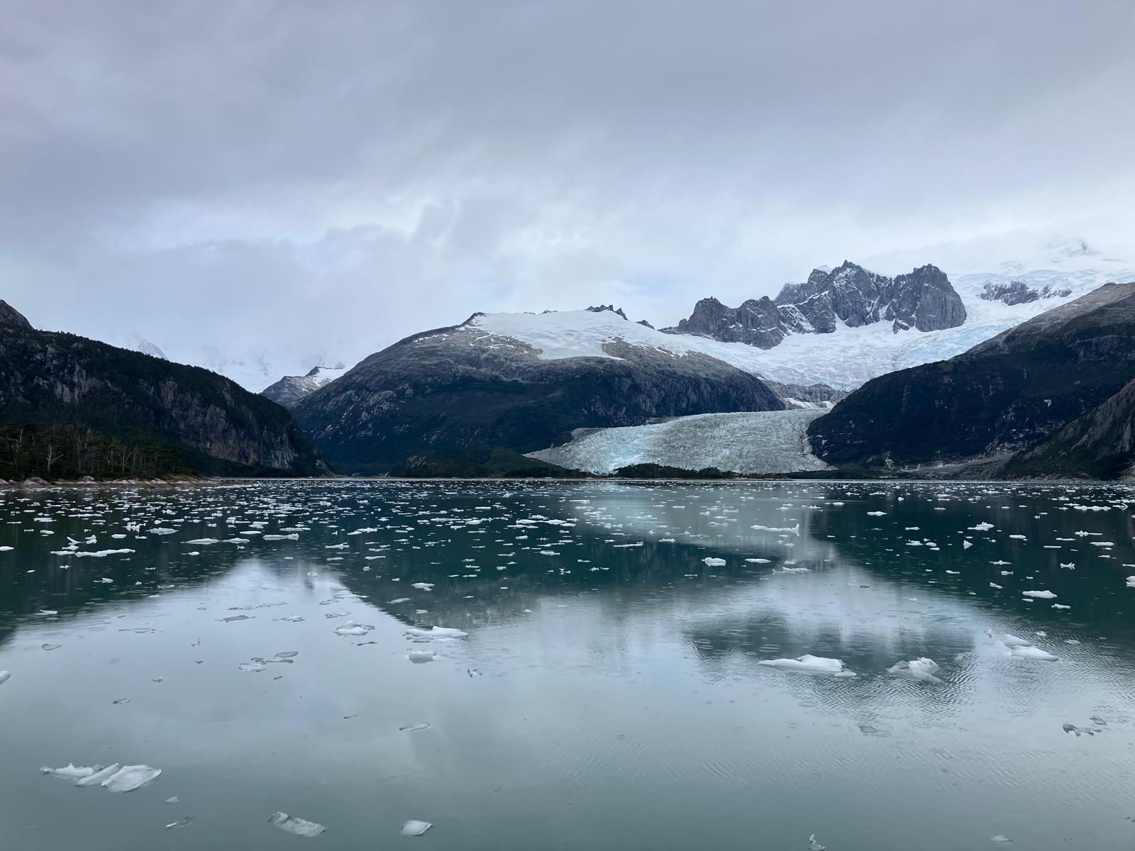
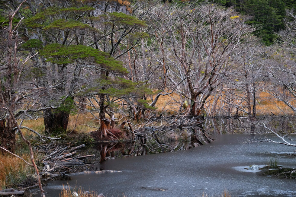
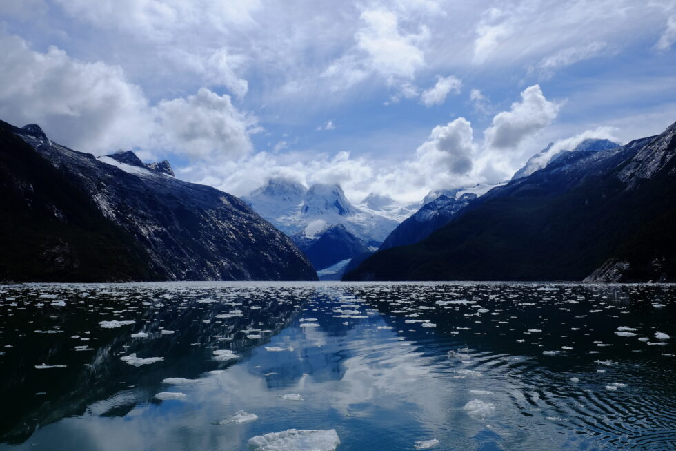
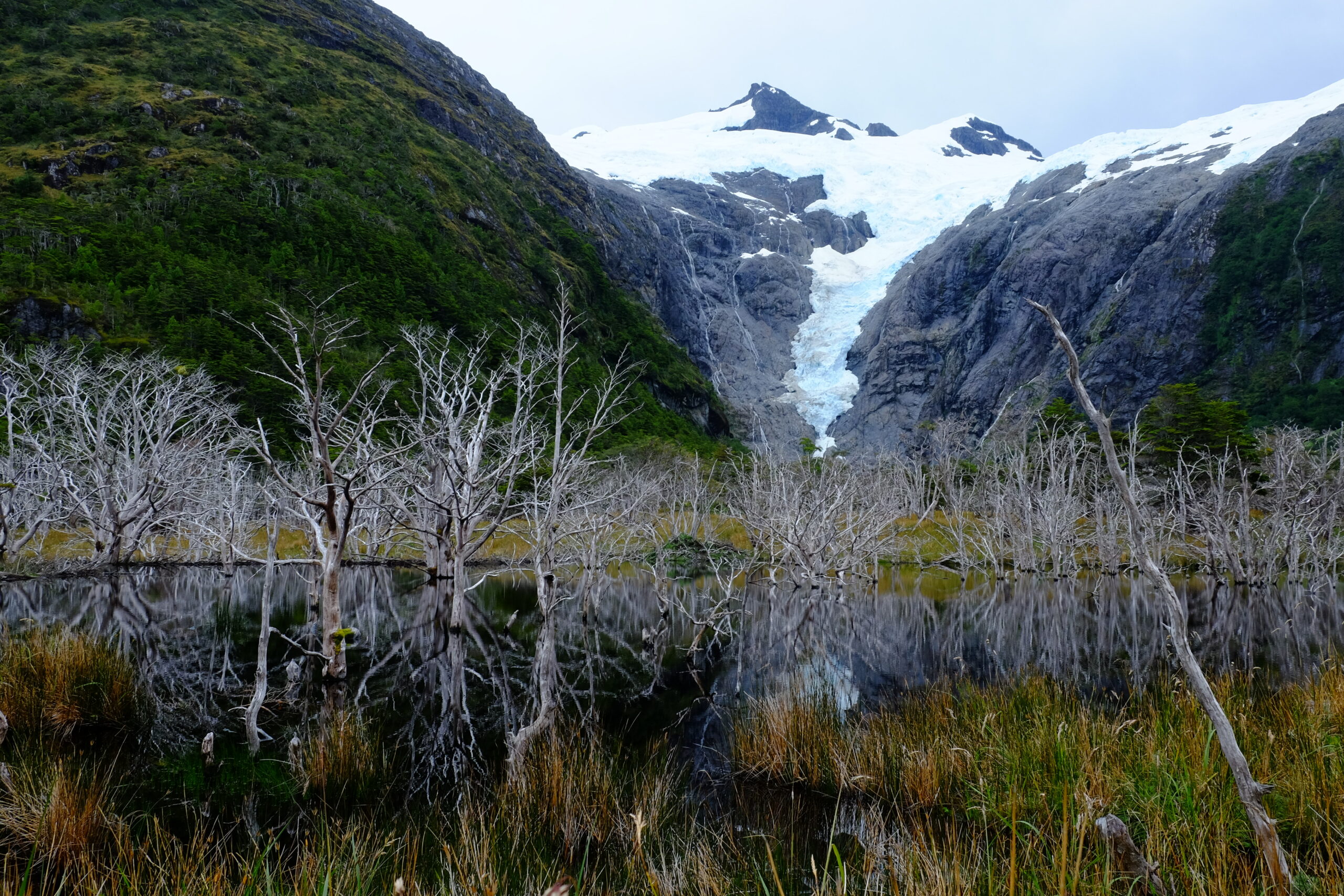
A glacier view in Pia fjord, Darwin cordillera, during a sailing expedition in the patagonian channels (February 2025)
1. Geography and geology
The cordillera extends 170 km west to east and 60 km north to south, between 54°15' and 54°50' south latitude. It is surrounded by water on three sides: the Almirantazgo Canal to the north, the Beagle Channel to the south, the Cockburn Canal to the west. Only its eastern edge, near the Argentine–Chilean border, remains connected to land.
Its highest point is Mount Shipton (2,469 m) — not Mount Darwin (2,438 m), a confusion that persisted for decades following Eric Shipton's 1961 expedition. The ice field covers 2,300 km², equivalent to the combined area of all Alpine glaciers, making it Chile's third-largest freshwater reserve after the Northern and Southern Patagonian Ice Fields.
The massif is built around a high-grade metamorphic complex — kyanite and sillimanite schists formed during the closure of the Rocas Verdes basin in the Cretaceous. These minerals signal extreme pressures and temperatures in the crust, making this the only ensemble of its kind in the southern Andes. The opening of the Drake Passage 45 million years ago subsequently shifted the local tectonic regime to transpressive.
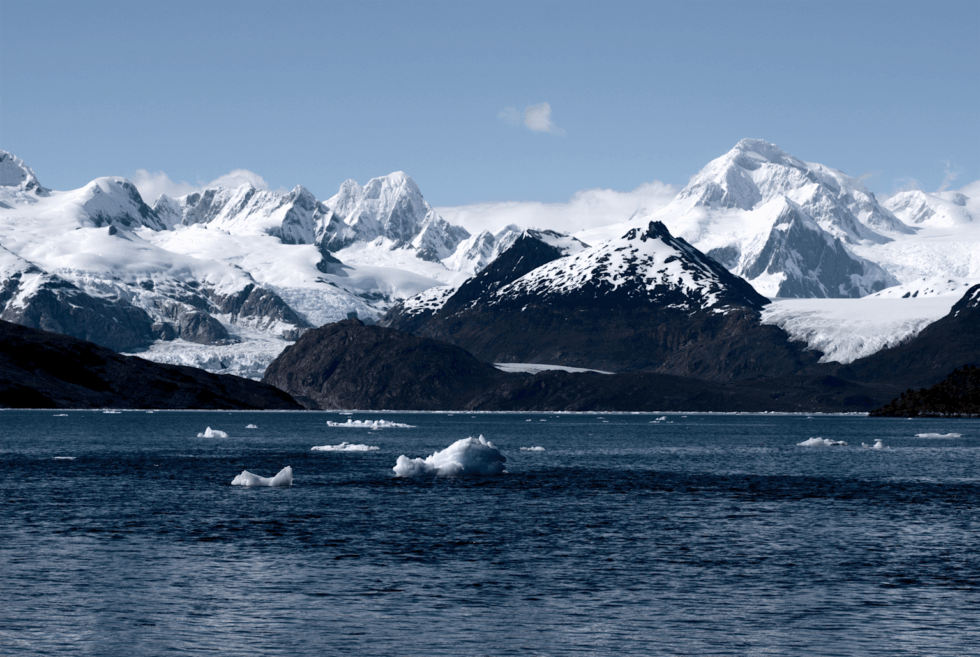
Among the dozens of glaciers in the massif, the Marinelli Glacier is the most studied and most active. It stretches from the cordillera to Ainsworth Bay in the Almirantazgo Fjord. Between 1913 and 2011, its front retreated 15 km — one of the highest retreat rates documented globally for a glacier of this type.
The Darwin Cordillera constitutes a natural laboratory for studying ocean–atmosphere–cryosphere interactions at southern high latitudes. Field data feed directly into global climate models.
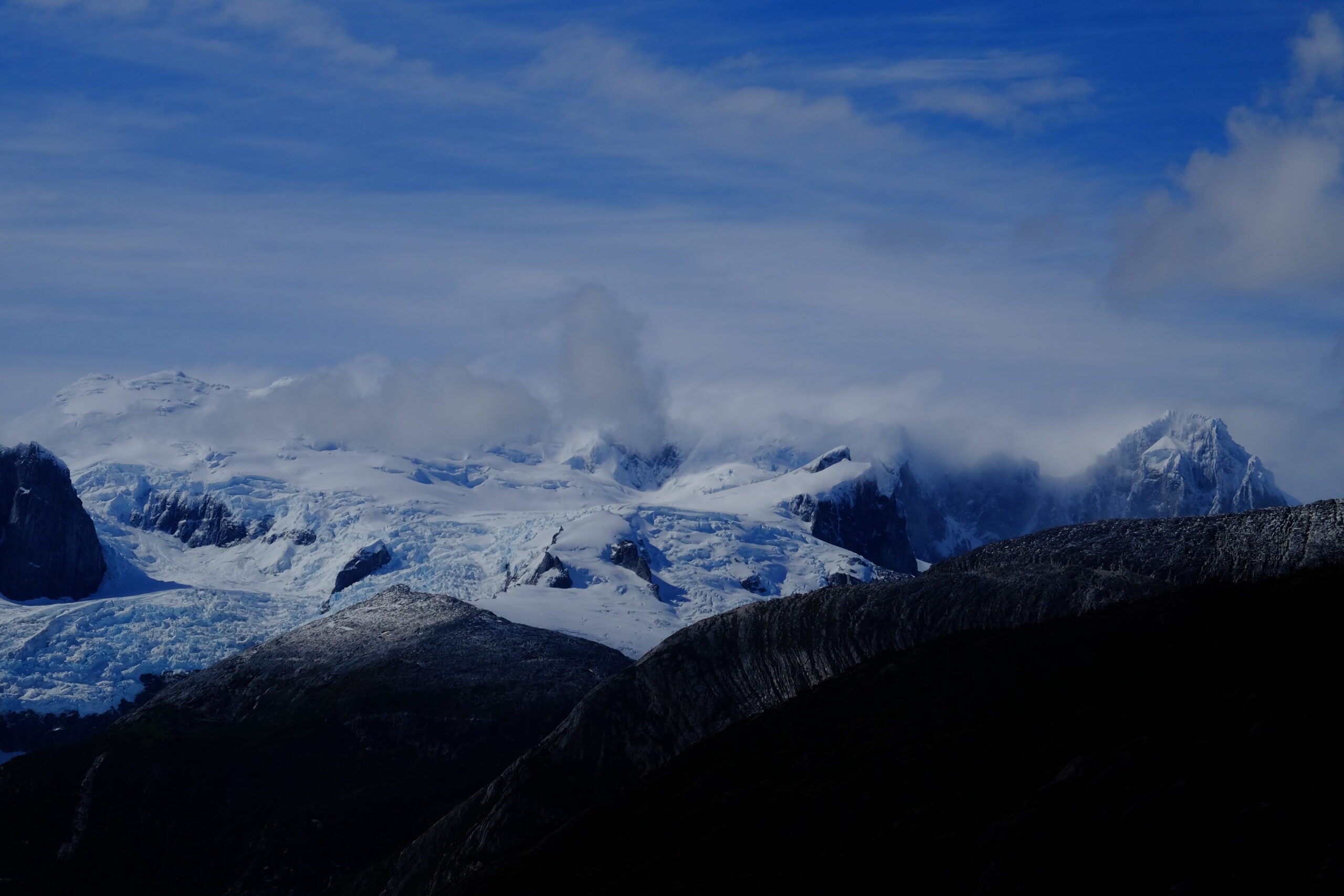
Panoramic view of Marinelli Glacier with snow-capped peaks and growlers (Darwin Cordillera, wikipedia)
Extreme climate: the Roaring Fifties
Westerly winds are constant. In the Roaring Fifties, their average annual speed reaches 70 km/h. Williwaws — katabatic gusts tumbling down slopes without warning, a Kawésqar word — can exceed 250 km/h. Annual precipitation exceeds 3,000 mm, mostly as snow at altitude. Visibility collapses in minutes.
FitzRoy called these conditions a "wicked divinity." One hundred and fifty years of failed exploration attempts proved him right.
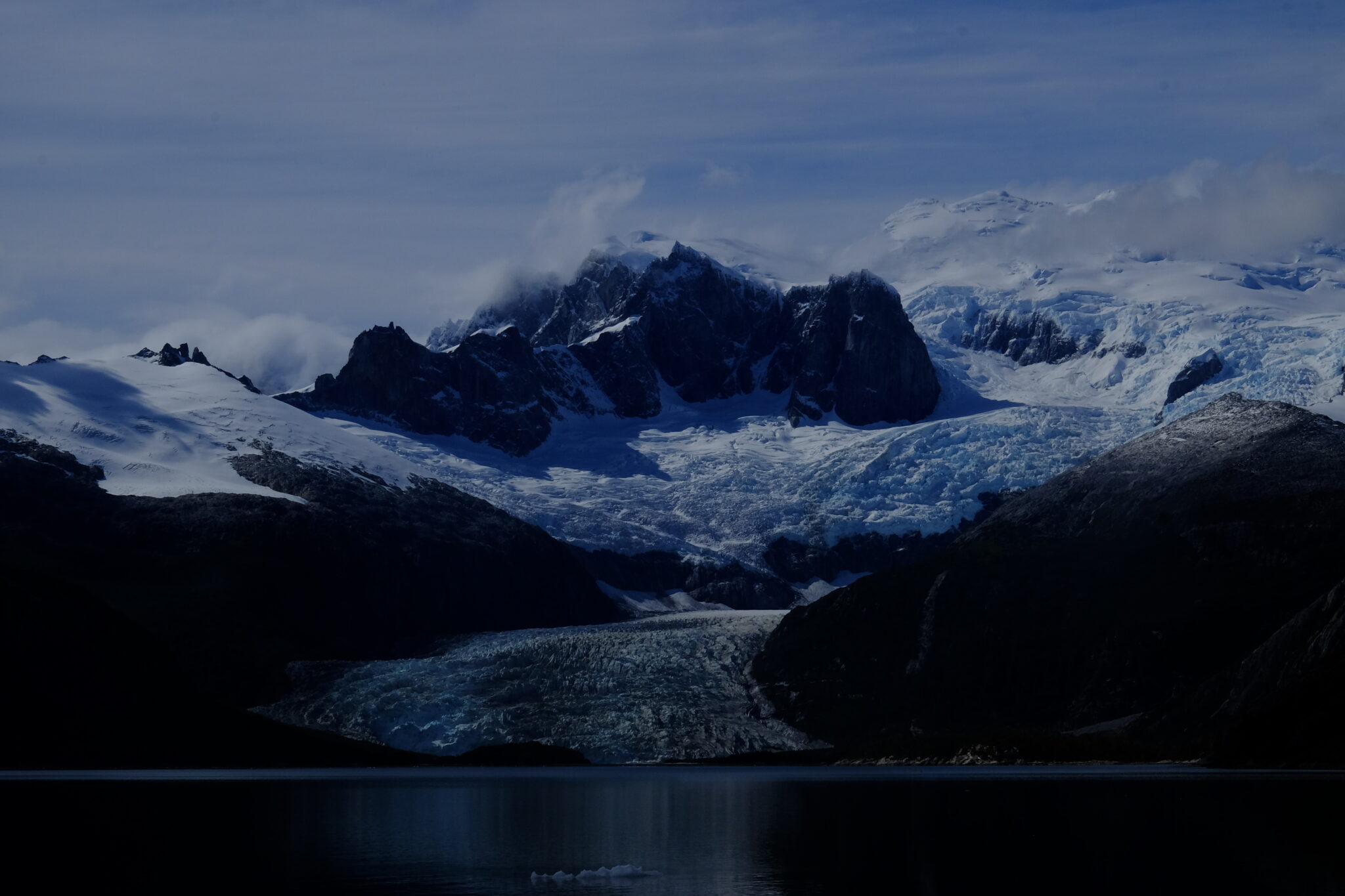
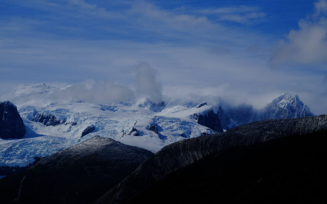
One of the patagonian glaciers of the Cordillera Darwin during a sailing expedition in the channels (Karukinka Association, Chile, 2025)
Average temperature varies between 0 and 5°C during the cold season (southern winter) and between 5 and 10°C during the warm season (southern summer). These relatively slight thermal variations reflect the moderating influence of the ocean, but mask the constant cooling effect of wind that considerably lowers the perceived temperature.
4. Biodiversity
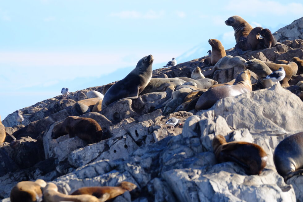
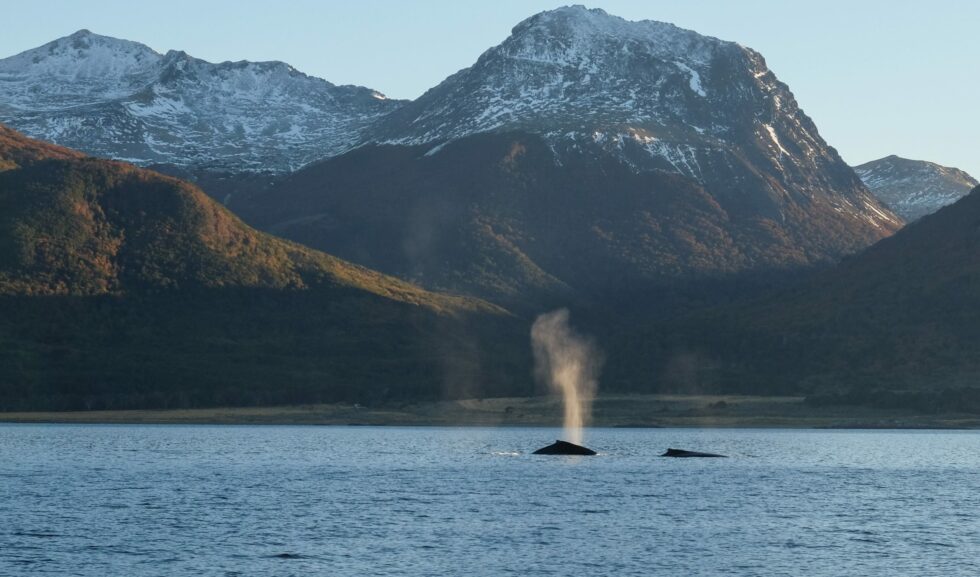
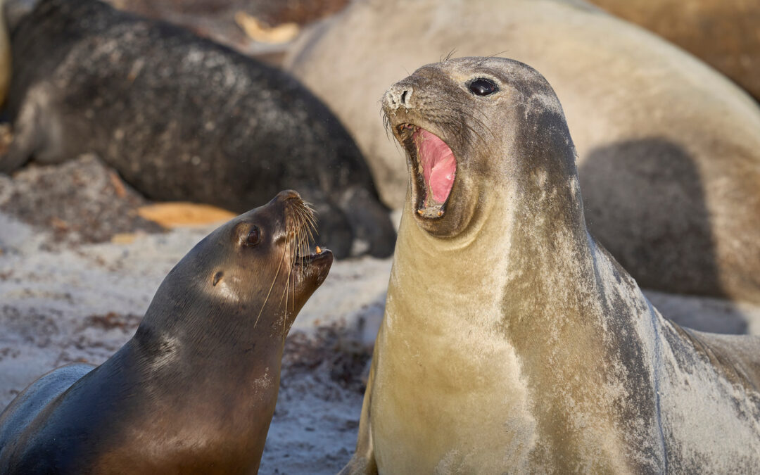
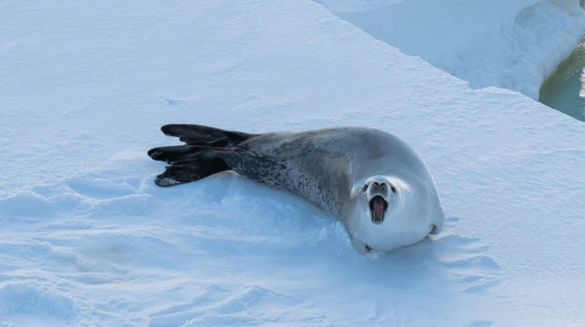
Fauna. Nutrient-rich fjord waters support humpback and southern right whales. Sea lions, elephant seals and leopard seals frequent the rocky coasts. Over 90 bird species have been recorded, including the Andean condor (wingspan up to 3 m) and, remarkably, the only colony of king penguins (Aptenodytes patagonicus) located outside Antarctica and the subantarctic islands.
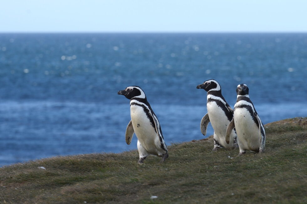
Small group of Magellanic penguins (pingüinos) in insular Patagonia
Colony of fur sea lions in the Beagle Channel (Karukinka sailing expedition 2025)
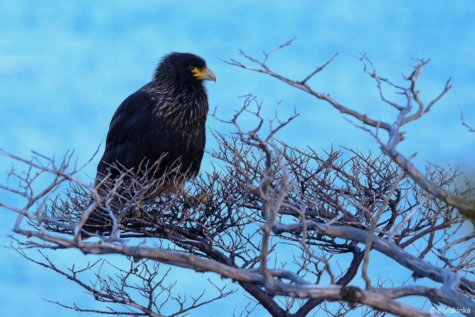
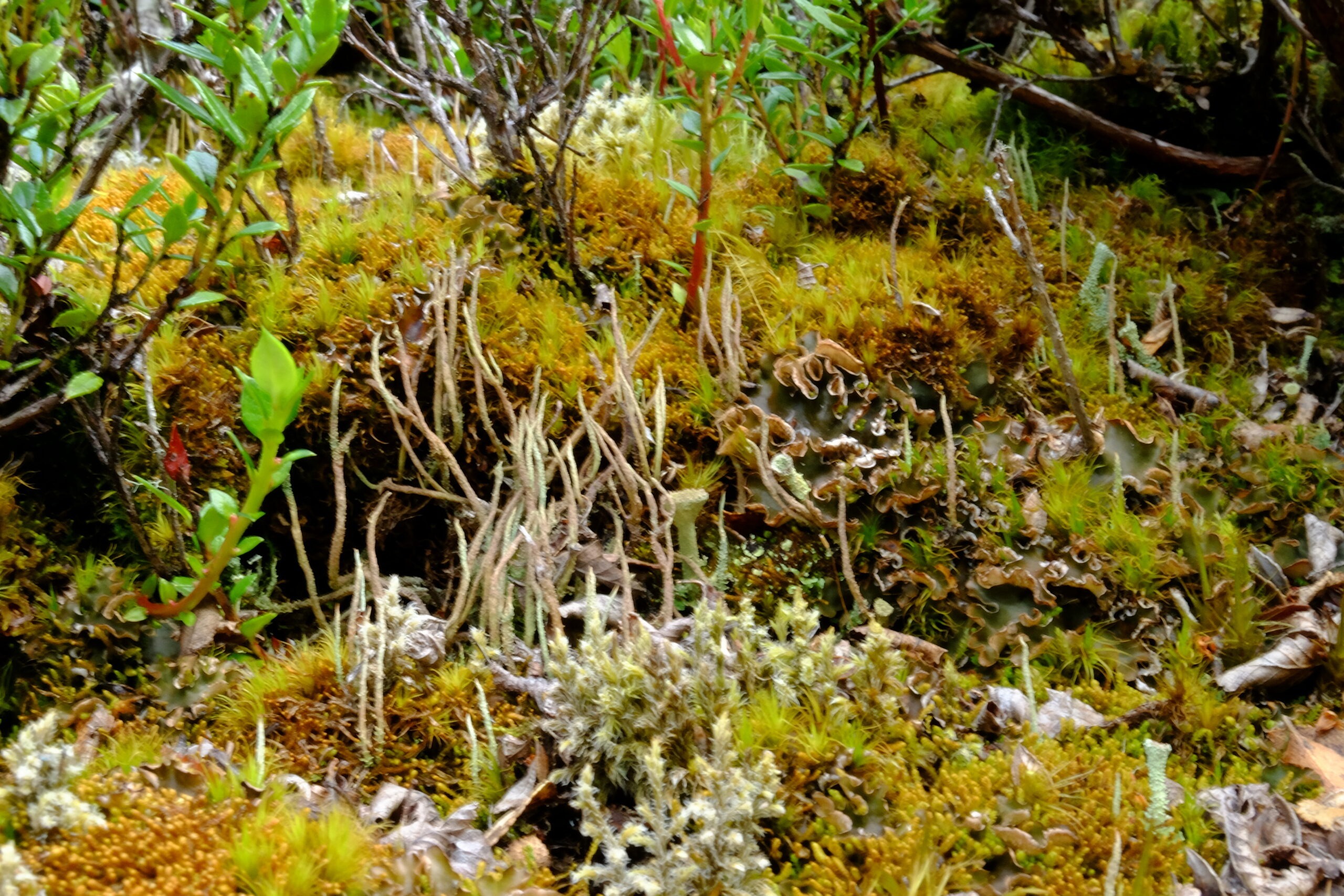
A black Carancho (Reserve of Cape Horn, April 10, 2025, during a sailing expedition at Cape Horn and in the Patagonian channels)
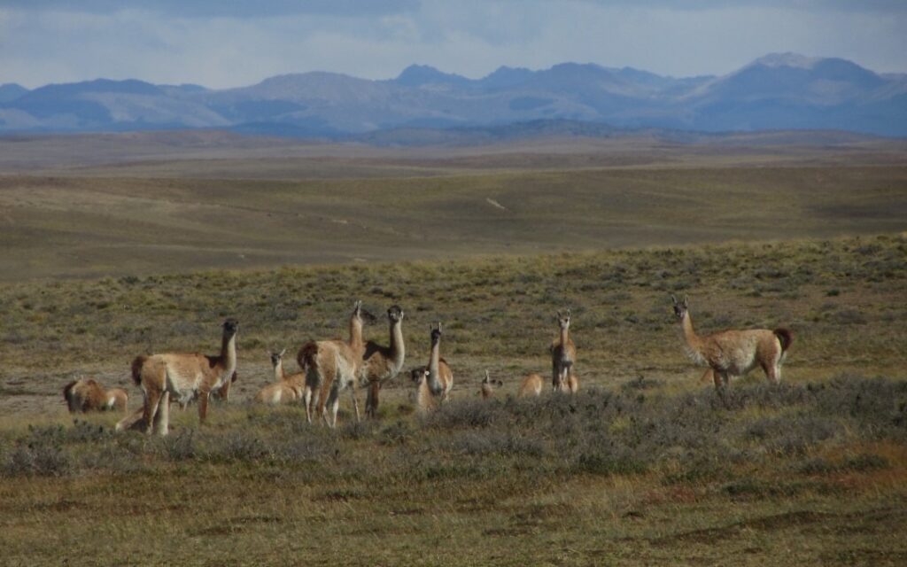
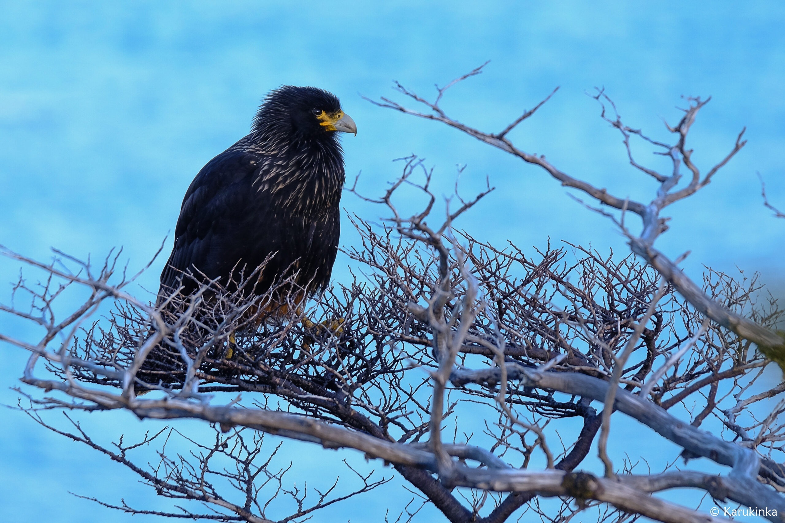
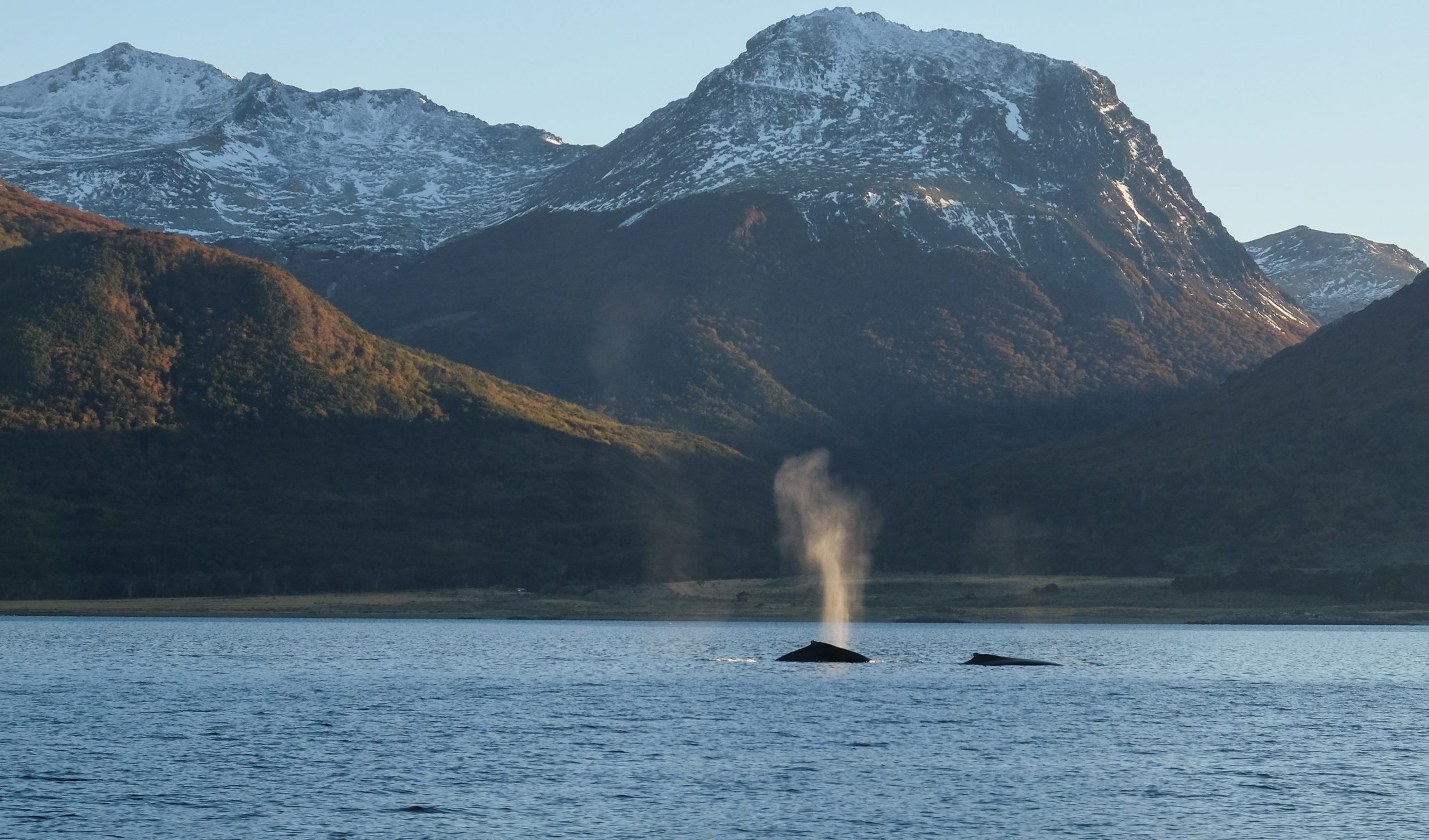
Two southern right whales in the Beagle Channel (2018)Herd of guanacos (Lama guanicoe) during an expedition of the Karukinka association in Tierra del Fuego (2018)
On land, the guanaco (Lama guanicoe) roams the least exposed zones. Canadian beavers, introduced in the 1940s, have colonised tens of thousands of hectares, their dams altering watercourse hydrology and threatening Nothofagus forest integrity.
Beaver dam on Hoste Island (Cape Horn Biosphere Reserve, Chile, autumn-winter expedition 2018)
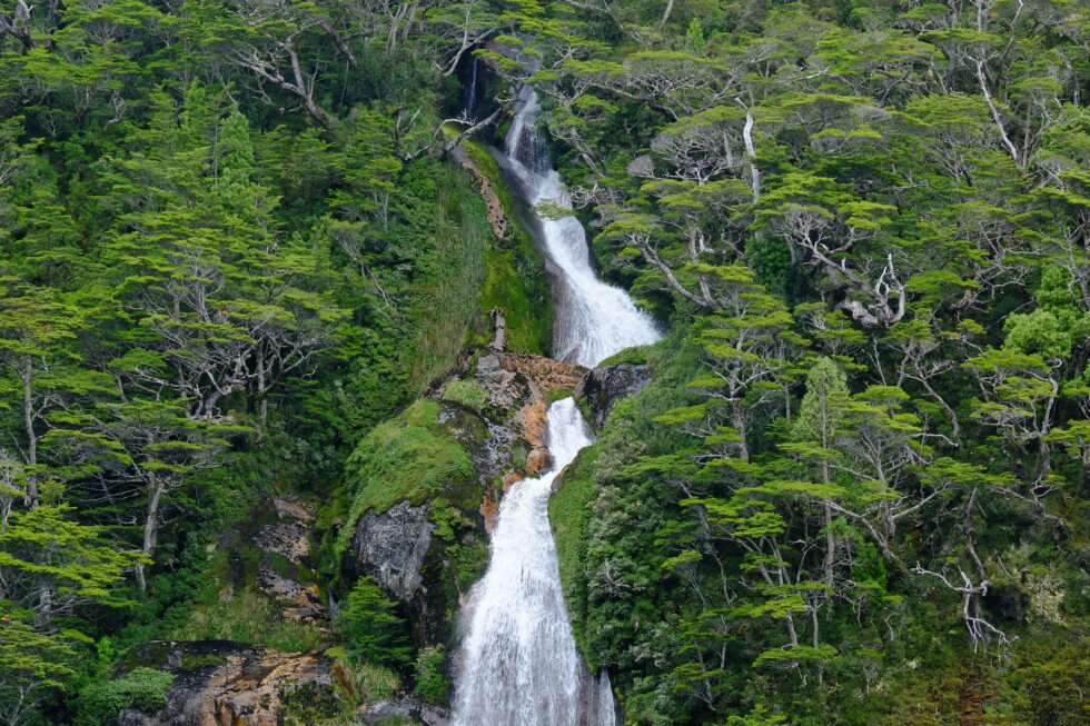
Magellanic forest photographed during a sailing expedition in Patagonia (Beagle Channel, Cape Horn Biosphere Reserve, Chile, 2025)
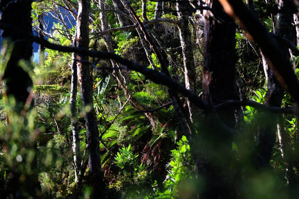
Vegetation of the Magellanic forest (Cape Horn Biosphere Reserve, 2018)
Vegetation. Lenga (N. pumilio) dominates up to 700 m altitude. Above that threshold, the same species grows as wind-sculpted dwarfs — same genetics, drastically reduced form. Higher still, Magellanic tundra takes over: mosses, lichens, Azorella, Bolax. Beneath the forest canopy, Drosera uniflora (a carnivorous plant) and several endemic orchid species signal the severe nutrient poverty of the soils.
Tundra landscape in the Cape Horn Biosphere Reserve (winter expedition 2018)
A transition zone marks the boundary between the forest tier and the alpine tier, where vegetation consists principally of mosses and lichens capable of resisting desiccating winds and negative temperatures. This Magellanic tundra constitutes a unique ecosystem, harboring highly specialized plant species.
5. First explorers
Father Alberto de Agostini, an Italian Salesian missionary, was the first to seriously penetrate the massif, between 1910 and 1960. His photographs — the first images of the cordillera's interior — and some twenty books on Patagonia constitute a foundational scientific and ethnographic heritage. The national park that protects the massif bears his name.
Alberto de Agostini and his climbing companions, pioneers of mountaineering in the Cordillera Darwin at the beginning of the 20th century.
In 1961, British alpinist Eric Shipton, with Chileans Eduardo García, Francisco Vivanco and Cedomir Marangunic, believed he had made the first ascent of Mount Darwin. The team had in fact climbed a higher summit to the north-west — the future Mount Shipton (2,469 m). The confusion was resolved in 1970 by a New Zealand expedition, whose proposed names were accepted by Chilean geographic authorities.
6. The GMHM first crossing (2011)
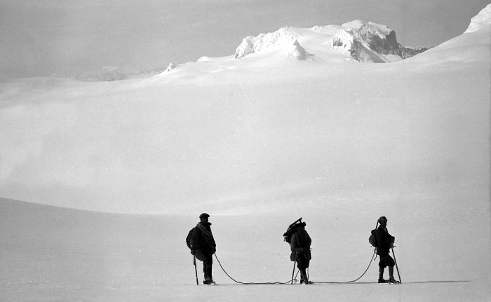
On 6 October 2011, six alpinists from the French Military High Mountain Group (GMHM) in Chamonix completed the first integral crossing of the Darwin Cordillera.
The team — Captain Lionel Albrieux (expedition leader), Lieutenant Didier Jourdain, Master Sergeant Sébastien Bohin, Staff Sergeant François Savary, Corporal Sébastien Ratel and civilian climber Dimitri Munoz — set off from the western slope on 6 September, fully self-sufficient, hauling 75 kg of equipment each on pulkas tested in Norway.
In 30 days they covered 150 km as the crow flies (250 actual km), with no reliable map since 1954. On the ridge facing Mount Darwin, a 5 km arête narrowed at times to 40 cm. Winds regularly reached 150 km/h. The team progressed at times on all fours, occasionally lying flat.
The documentary film On Darwin's Edge, made from footage shot by the team, was released on 30 October 2013.
7. Protection and challenges
Alberto de Agostini National Park, created on 22 January 1965 (Supreme Decree No. 80), covers 1,460,000 hectares — Chile's third-largest protected area. In 2005, it was incorporated into the UNESCO Cape Horn Biosphere Reserve, placing the cordillera among the planet's 24 most pristine ecoregions.
Three challenges dominate the conservation agenda: documented glacier retreat (Marinelli: –15 km over one century), the spread of Canadian beavers, and growing cruise ecotourism pressure toward the glaciers — which requires careful management, particularly around fragile, unenclosed Yagan archaeological sites on the coastline.
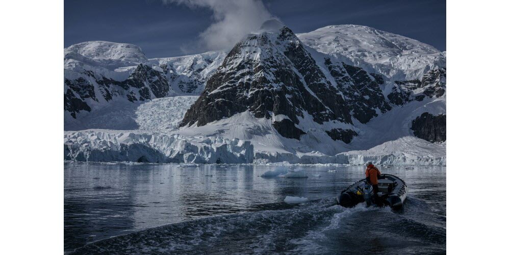
One of the many fjords of Alberto de Agostini National Park (sailing expedition, Patagonian Channels, Chile, 2025)
The Cabo de Hornos Biosphere Reserve (Cape Horn Nature Reserve), established in 2005, is one of the southernmost and largest protected areas in the world, covering more than 4,884,000 hectares of southern lands and waters. It contains unique terrestrial and marine ecosystems, pristine subantarctic forests, remarkable biodiversity—including over 5% of the world’s bryophyte diversity—and the populations of the Yaghan people, who maintain a millennia-old connection with these extreme landscapes.
Table des matières
The Cabo de Hornos Biosphere Reserve was included in UNESCO’s “Man and the Biosphere” program in June 2005, becoming both the southernmost and one of the largest biosphere reserves in South America. Spanning about 4,884,274 hectares, it comprises a terrestrial area of 1,917,238 ha and a marine area of 2,967,036 ha, integrating for the first time in Chile both marine and terrestrial ecosystems under a unified conservation status. The Alberto de Agostini and Cape Horn National Parks form the core protected area, where all infrastructure development is strictly prohibited.
1. Geography and zoning of the Cape Horn nature reserve
Geographically, the reserve extends across the Tierra del Fuego archipelago, between 54.1° S and 56.2° S latitude, and 66.1° W and 72.5° W longitude. It includes the Wollaston, Hermite, Navarino, and Hoste islands, as well as channels (including the Beagle Channel), fjords, and currents that form a landscape shaped by glaciations and tectonic activity. The UNESCO MAB Reserve zoning (Cabo de Hornos Biosphere Reserve, i.e., the southern Chilean marine reserve) is structured into three areas:
The core zone (Alberto de Agostini National Park including the Darwin Range, and Cape Horn National Park) is strictly protected.
The buffer zone, where light and sustainable activities are allowed.
The transition zone, including isolated villages like Puerto Williams and limited infrastructure under a sustainable development framework.
The reserve’s subantarctic forests are the southernmost on earth. Dominated by three Nothofagus species—N. pumilio, N. betuloides, and N. antarctica—they form both deciduous and evergreen stands, interspersed with peat bogs and alpine heaths. These forests are among the world’s rare examples of non-fragmented temperate forest. The organic-rich soils support vast carpets of bryophytes, typical of the cool, humid environment; these play a crucial role in the hydrological cycle and carbon sequestration.
2.2 Marine and coastal ecosystems
The marine component of the reserve centers around a complex network of fjords, channels, and underwater plateaus. The Humboldt current and the mixing of cold Pacific and Atlantic waters have fostered the development of kelp forests (Macrocystis pyrifera, Durvillaea antarctica) forming “underwater forests” that host diverse invertebrate fauna and fish communities. Intertidal habitats harbor macroalgae species and numerous endemic invertebrates, while the cold, oxygen-rich waters support populations of seals, sea lions, and several cetacean species.
3. Biological diversity and endemism: subantarctic biodiversity
3.1 Bryophytes and lichens
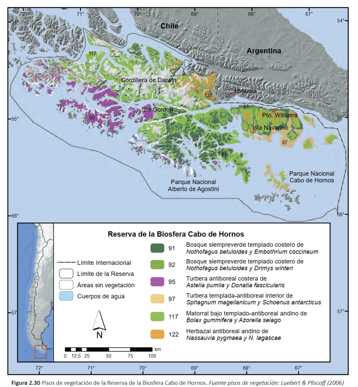
With over 300 species of liverworts and 450 species of mosses, the reserve is a global hotspot for bryophytes, representing more than 5% of global diversity on less than 0.01% of the world’s land surface. These communities, described as “miniature forests,” serve as sentinels for assessing the impacts of climate change and rising UV radiation.
Example of bryophytes / miniature forest (mosses, liverworts, and lichens) from the Cape Horn Biosphere Reserve (MAB-UNESCO); Navarino Island, 2020 (c) Lauriane Lemasson.
3.2 Terrestrial and marine fauna
Terrestrial fauna include the southern river otter (Lontra provocax), the Magellanic woodpecker (Campephilus magellanicus), and other endemic birds. In the marine environment, the surrounding waters are home to black-browed albatross, giant petrels, Magellanic penguins, and stable populations of fur seals and leopard seals, highlighting the ecological importance of this protected area.
A black Carancho from Martial Bay (Cape Horn Reserve, April 10, 2025, during a sailing expedition at Cape Horn and in the Patagonian channels)Whales in the Beagle Channel during the 2018 expedition (Karukinka Association)
4. Biocultural dimension and Yaghan ethnology
The reserve is also a cultural sanctuary. The Yaghan, nomadic people of the southern channels, are the world’s southernmost indigenous group, with a presence dating back over 7,500 years, as evidenced by archaeological sites on Navarino Island. They continue to possess expert knowledge of canoe navigation and subantarctic ecology, and have actively participated in research within the reserve, particularly through the Omora Ethnobotanical Park near Puerto Williams. Their oral traditions, language, and knowledge of local flora and fauna are incorporated into educational and conservation programs. Ecotourism in Patagonia is also a key activity of the Omora initiative.
5. Governance and management
The reserve is managed by a board chaired by the regional governor, involving public agencies and local organizations. The scientific committee, coordinated by the Omora Park and the University of Magallanes, leads research, ecological monitoring, and participatory conservation efforts. In 2006, the reserve joined UNESCO’s Ibero-MAB network, strengthening transnational cooperation for research and training.
6. Threats and conservation challenges
Despite its isolation, the reserve faces several threats:
Uncontrolled tourism development, particularly southern cruises and increased traffic around Cape Horn, poses risks of pollution and disturbance to marine wildlife.
Intensive salmon farming in northern fjords introduces exotic species and degrades water quality. Salmon now breed in these waters, impacting native species such as the robalo.
The spread of introduced species such as the North American beaver and mink threatens riparian forests, streamside habitats, and shorebird nesting sites.
Long-term monitoring programs, such as the Omora initiative and Long-Term Ecological Research (LTER) stations, assess these pressures and propose adaptive measures. However, monitoring is hampered by the vastness of the reserve and its logistical challenges.
Lake created at the foot of a glacier by beavers, photographed during a sailing expedition in Patagonia (Beagle Channel, Hoste Island, Cape Horn Biosphere Reserve, Chile).
7. Research and education initiatives
7.1 Omora Ethnobotanical Park
Founded in 2000, the Omora Ethnobotanical Park is at the center of a transdisciplinary approach combining ecology, environmental philosophy, and “field philosophy” education. It offers educational trails, including “miniature forests,” to raise public awareness of bryophyte diversity and the link between biodiversity and Yaghan culture.
7.2 Cape Horn International Center (CHIC)
Inaugurated in 2020 in Puerto Williams, CHIC brings together researchers, artists, and indigenous communities to develop a model for biocultural conservation, technical training, and sustainable development. Its programs address the responses of biodiversity to climate change, the management of invasive species, and the formulation of public policy adapted to subantarctic zones.
The Cabo de Hornos Biosphere Reserve remains one of the rare refuges where harmonious coexistence between local inhabitants and ecosystems at the literal edge of the world is fully realized. Securing its future means strengthening participatory governance, managing invasive species, and supervising polar tourism under the banner of responsible ecotourism. Finally, the ongoing integration of Yaghan knowledge in research and education programs will ensure the preservation of both the biological and cultural heritage of this unique subantarctic sanctuary.
Pia Glacier, Patagonian Channels, Darwin Range, Cape Horn Biosphere Reserve, Magallanes, Chile, 2025
Bibliography
Rozzi, R. et al. (2006). Ten Principles for Biocultural Conservation at the Southern Tip of the Americas: The Cape Horn Biosphere Reserve. Ecology and Society, 11(1). https://www.ecologyandsociety.org/vol11/iss1/art43/
Rozzi, R. et al. (2004). Omora Ethnobotanical Park: A Model for Integrating Biocultural Conservation and Environmental Philosophy in the Cape Horn Biosphere Reserve. Environmental Ethics, 26(2), 131–169. https://doi.org/10.5840/enviroethics200426226
Mittermeier, R. A. et al. (2003). Hotspots: Earth’s Biologically Richest and Most Endangered Terrestrial Ecoregions. Conservation International. https://www.conservation.org
CONAF (Corporación Nacional Forestal). (2023). Reserva de la Biósfera Cabo de Hornos. Gobierno de Chile. https://www.chilebosque.cl
Cape Horn International Center (CHIC). (2021). CHIC Strategic Plan 2021–2026. Universidad de Magallanes. https://www.centrochic.cl
Anderson, C.B. et al. (2011). Exotic ecosystem engineers transform sub-Antarctic forest structure and function. Biological Invasions, 13, 545–561. https://doi.org/10.1007/s10530-010-9841-4
Anderson, C.B. et al. (2019). Cape Horn’s Lessons for Sustainability. Science Advances (UNESCO CHIC/UMAG). https://advances.sciencemag.org/
Rozzi, R. et al. (2010). La Reserva de Biósfera Cabo de Hornos: una propuesta educativa y de desarrollo sustentable en el extremo austral de Chile. Universidad de Magallanes. Disponible sur la bibliothèque CHIC.
An outbreak of avian flu in 2023 hammered a colony of southern elephant seals in Chile’s Tierra del Fuego region, leading to a 50% decline in its population.
But over the 2024-2025 breeding season, the colony’s population recovered, with 33 pups being born.
An alliance between the Chilean branch of the Wildlife Conservation Society and the regional environmental department has been monitoring this particular colony for years, braving the remoteness and extreme weather at the southern tip of the Americas.
Experts posit that the site, Jackson Bay, may serve as a natural refuge from the avian flu because it’s geographically isolated as a fjord.
Year after year, a colony of elephant seals arrives in Jackson Bay, on the islands of Tierra del Fuego at the southern tip of Chile, to molt and breed. However, in 2023, an outbreak of avian flu devastated the region, and the colony’s population dropped by half.
In 2020, when avian flu caused devastating losses in seabird colonies in Europe and Southern Africa, experts initially thought the virus’s spread to mammals would be limited to terrestrial carnivores. However, during the outbreak in 2021 and 2022, the virus affected seals and whales in both Europe and North America. In 2023, when the virus arrived on the South American coast, the pathogen showed that it was capable of causing large-scale mortality among marine mammals. The southern elephant seal (Mirounga leonina) was one of the most heavily impacted species.
But good news arrived in April 2025, when researchers found that the elephant seal population in Jackson Bay had doubled to 200 individuals, including 33 pups.
“It is great news for the conservation of the species, because Jackson [Bay], by being in inland waters of fjords and canals, may act as a protective barrier against pandemics,” says Cristóbal Arredondo, a veterinarian and terrestrial program coordinator for the Wildlife Conservation Society (WCS) Chile,. Since 2008, WCS Chile has monitored this colony alongside the environmental department of the Magallanes region, which encompasses Tierra del Fuego.
Elephant seals in Jackson Bay. Image courtesy of Francisco Brañas.
A refuge from the virus
Jackson Bay is home to “the largest elephant seal colony in Chile,” according to Javiera Constanzo, a veterinarian and the One Health approach manager for WCS Chile. The bay is located between two protected areas: the Multiple Use Marine and Coastal Protected Area Seno Almirantazgo, or Admiralty Sound, which is administered by the Ministry of the Environment, and Karukinka Natural Park, which is a private conservation initiative administered by WCS Chile.
Karukinka Natural Park is a vast natural refuge that spans approximately 300,000 hectares (741,000 acres) of diverse ecosystems. Admiralty Sound, which surrounds the coasts of Karukinka, receives freshwater from several glaciers in the Cordillera Darwin, an ice-capped mountain range. Since Admiralty Sound is a large fjord — a deep, narrow valley with glacial origins that has been filled with seawater — it’s mix of freshwater and saltwater makes it highly productive. And as a government-protected area, Admiralty Sound is vital for the elephant seal population, Constanzo says, by prohibiting activities that could affect the species.
Above all, Jackson Bay’s isolation might make it a refuge for the colony of elephant seals. This hypothesis is still being studied, but “what is being observed is very positive for the conservation of the species,” Constanzo says.
During the most recent season, 33 pups were born. Image courtesy of WCS.
Successful monitoring after 2023 avian flu
Data from satellite transmitters show that some of the Jackson Bay elephant seals stay put while others migrate from different places, coming from the Pacific Ocean or traveling in the Atlantic until they reach the Valdés Peninsula in the central Argentine Patagonia.
In 2023, during the highly pathogenic avian flu outbreak, there was a mass die-off of elephant seals in Argentina: according to a study published in Nature Communications, approximately 17,000 of the animals died.
At Jackson Bay, researchers recorded only about 100 individuals in the colony that year, less than half of the number recorded in prior years.
“We eagerly hoped that in the following season, the colony’s numbers would recover,” Arredondo says. And they did. The 2024-2025 season resolved any doubt: 200 elephant seals were seen in Jackson Bay in December, which is the month when the colony’s population normally peaks. Researchers also recorded the births of more than 30 elephant seal pups, the same number as recorded in 2023.
Researchers from WCS Chile and the Magallanes regional department of the environment in Jackson Bay. Image courtesy of Francisco Brañas.
The colony in Jackson Bay has “now recovered its numbers after the avian flu,” Constanzo says.
Experts attribute the rapid reestablishment of the elephant seal colony in Jackson Bay to several factors. For one, its location in the inland waters of fjords and canals, far from other affected colonies, may have served as a natural barrier against avian flu, reducing the risk of contagion.
The researchers suggest that elephant seals that contracted the highly pathogenic avian flu virus may not have managed to return to Jackson Bay, likely dying before reaching their destination.
About 200 elephant seals were seen in Jackson Bay in December 2024. Image courtesy of WCS.
Monitoring in an extreme area
Wind speeds in Jackson Bay can hit up to 120 kilometers per hour (75 miles per hour), presenting significant challenges for researchers as they disembark. However, this didn’t stop marine biologist Marina Maritza Sepúlveda from traveling to Jackson Bay in 2023 with a team of Chilean and British scientists. They fitted satellite transmitters on several elephant seals arriving in Jackson Bay, part of an ongoing project that WCS Chile is supporting.
Sepúlveda says the transmitters help scientists track the colony as it travels along the Cape Horn Current, one of the “least-studied and [least-]known currents in Chile,” and one that is “extremely important to understand.”
WCS Chile has also joined the team to monitor the colony of elephant seals. Given the high logistical cost of reaching the area, every opportunity to collect data is taken advantage of.
“The opportunity to have the animals there lets us maximize the chance to gather valuable scientific data,” Sepúlveda says. For example, veterinarians like Arredondo and Constanzo collect nasal and anal swabs to study the elephant seals’ microbiome, including their bacteria and virus loads.
Jackson Bay is located in an area where wind speeds can hit up to 120 km/h. Image courtesy of WCS.
The researchers also gather data by using an ultrasound to measure the elephant seals’ fat layers, which allows for an assessment of their body condition. They extract whiskers and fur samples to analyze the seals’ trophic ecology and check for the presence of heavy metals, and they collect droppings to test for parasites.
During the most recent season, researchers also collected samples to confirm the presence of avian flu in the colony. Those samples are now being processed.
“Teamwork allows us to optimize resources, share knowledge and ensure the collection of valuable data that contribute to the understanding and conservation of this colony of elephant seals,” Arredondo says.
Researchers have been monitoring the elephant seal colony in Jackson Bay as a long-term project for more than 16 years.
Every year between October and April, a small team hikes across the entire beach and coastal area. During these inspections, the researchers categorize the elephant seals by age and sex, which helps them understand the population composition of the colony. However, depending on a seal’s position on the ground, some individuals can’t be identified; in those cases, scientists put them into the “sex not determined” category, Constanzo says.
Every year between October and April, a small team of researchers travels across the entire beach and coastal area to gather information about elephant seals. Image courtesy of WCS.
Elephant seals spend most of their lives in the water and only travel onto land to breed and molt, in a process that takes about one month. During this time, they don’t enter the water for food. This means that any change that increases their energy consumption is a problem, according to Arredondo. That’s why the researchers ensure they maintain a safe distance from the seals that “does not disrupt” their behavior.
In addition to counting elephant seals in person, they also used drones to map the area. These help researchers collect detailed images of the locations of the elephant seals.
Francisco Brañas, an expert with the protected areas unit of the regional environmental department, says processing these images can allow researchers to obtain additional information, such as individual measurements. Researchers can estimate the elephant seals’ body weight and evaluate their physical condition to determine whether they have sufficient food, according to Brañas.
“The images captured by the drones provide us with a more complete and precise view of the colony,” he says.
Regular monitoring has been key to evaluating the recovery of the colony, which was first described in 2006. That year, 46 individuals were recorded. Since then, the numbers have grown overall.
The striking increase in the elephant seal population in Jackson Bay is not only a testament to the species’ resilience, but it also reflects the collaborative efforts that are crucial to carrying out this monitoring work in a remote and extreme-weather area.
Elephant seals spend most of their lives in the water and only travel onto land to breed and molt. Image courtesy of Pablo Lloncón.
Banner image of an elephant seal in Jackson Bay, courtesy of Francisco Brañas.
This story was first published here in Spanish on May 1, 2025.
The president of the Commission 3 of the Provincial Parliament, Legislator Laura Colazo, conducted a meeting with the indigenous people communities. This is an initiative from the Green deputy to include them in the decision making within the Consultative Commission of the Indigenous Forests (CCIF). « We have the opportunity to acknowledge and make the autochthonous people of our Province visible who have lived and still live on these lands and offer a historical rectification, she declared. She also mentioned the necessity to expand the energetic matrix of the province to support a sustainable production process.
Source: https://www.radiouniversidad.com.ar/2024/08/26/dictamen-para-que-pueblos-originarios-participen-en-el-consejo-consultivo-provincial-de-bosques-nativos/ Translated from Spanish into French by the Karukinka association.
Río Grande. Last Thursday, Legislator María Laura Colazo (Green Party) attended a new meeting of the Natural Resources Commission n°3, which she presided. This was the occasion to discuss her initiative dedicated to “The 109/24 Case” with the aim of promoting the permanent integration of the representatives of the autochthonous people to the Consultative Commission of the Indigenous Forests (CCIF).
To this motive, the Parliamentary appreciated the attendance of the members of the communities: Rafaela Ishton and Paiakoala. “We have the opportunity to acknowledge and make the autochthonous people of our province visible who have lived and still live on these lands, and to offer a historical rectification”, declared Colazo.
The Parliamentary also underlined the utmost importance of the Selk’nam and Yagán people’s voices being part of the CCIF and that they have their place in this consultative body. “This is why we invited them, we wanted to have their support.”
She also added that this way they are “integrated” into the territorial discussion and planning processes. The Selk’nam people is the only autochthonous people who own their community propriety title”, she added.
It’s worth noting that the initiative includes amendments to provincial law n°869. In Article 14 of the aforementioned standard, the paragraph “q” is added, which specifies the integration of a representative for each indigenous community from the province with a legal status registered on national level.
Eleonora Anderson Varela, herself, from Rafaela Ishton’s community was thankful for this space: « We are delighted to have a place at the CCIF, this is a historical event for us. The community owns approximately 36000 hectares of which 80% are made of forests”, she declared.
Another member of the community, Alexis González Palma, told them “It is very important for us because they are giving us back our dignity and the possibility to tackle issues which affect us as autochthonous people of these lands”, he declared.
It’s worth noting that Tarcisio Vargas and Damián Nenes Vargas, from the Yagán people, also attended the Commission meeting as representatives of the Paiakoala community.
« Today, the autochthonous people are beginning to be respected. Taking care of our forests is good not only for the communities but also for the totality of the population. We risk losing the canelo and need to take care of it together”, declared Vargas, a Yagán referent.
Legislatofs Raúl Von Der Ensuren and Lechman (SF), Juan Carlos Pino (PJ), Federico Greve and Federico Sciurano (FORJA), as well as Legislatir Gisela Dos Santos (SF) were present.
Two million dollars for the Native Forests
It’s worth noting that Legislator María Laura Colazo attended the second annual meeting of the Consultative Commission of the Indigenous Forests of which she is a member, and which was held at Tolhuin Tourism Secretary beginning of August.
On that occasion, the working paths which will be followed were analysed, after it was learnt that the “Green fund for the climate» programme, which will be run through United Nations Organisation for food and agriculture (FAO), and rising from an initiative led by the national government and the province and called Reduction of the Emissions related to the Deforestation and Degradation of the forests (REDD).
The programme comes to the Land of Fire with a component which will be dedicated to the forest conservation work with the autochthonous communities, among which the global community Plan with Rafaela Ishton’s Selk’nam community and also at the productive development of the forestry bay of Tolhuin; the other component will also be used for the prevention of wood fire at the interface of Ushuaia. It’s worth noting that, according to the programme of fire prevention at the forest-urban area interface, we mean by fire a “fire which grows in the transition areas between the urban, rural or forestry areas where the structures of the buildings are mingled with the plants».
Approximately two million dollars will be allocated to the Land of Fire province “and the project in general, as mentioned by Engineer Francisco Jofré who is FAO’s representative which is in the province, is approximately 85 million dollars for the totality of the country in this programme called RedMás, a specific programme also related to the climatic change.
Members of the Forest National Board of Management and the FAO for the Payments at Results project attended the meeting, as well as managers of the provincial government and representatives of the institutions forming the CCIF.
It’s worth noting that the United Nations Organisation for the food and agriculture better known as FAO and a specialised agency of UNO leading international activities which aims at eradicating hunger.
The organisation is conducting several projects implemented all around the country. It plays a fundamental role in striving towards food safety, family farming reinforcement, transformation of food-processing systems and sustainable development.
“A lot of families live off the forestry sector”
During a talk with “La Mañana de Tecno”, broadcast on Radio Universidad 93,5 MHz, the Green Parliamentary reminded that the forestry consultative commission “is taking place under the 869 provincial law and is a environment composed of various actors” who are related to everything concerning the use of the whole forestry sector, what is active in our province. So, as a representative of the legislative Assembly, I have to be part of this space.”
Laura Colazo explained that « the members of FAO, an international organisation under the United Nations, benefit from specific financing programmes used to manage several projects in our country. And in this project which is very important and in the making in 23 provinces : we are working on those 3 issues in our province, which are the ones we talked about within the commission in order to grant approval to all the members to make progress in this area, while being able to follow through the community integration plans that the Forestry General Board of Directors works very well with the Selk’nam persons who have set up their authorities very recently, who have held elections. And the truth is that they have very interesting projects to be accomplished in our province, particularly in their community propriety, which represents 35 000 hectares owned in the Tolhuín region. And it is very important to achieve sustainable use, and the truth is that we think it is also important to assist them because it requires means to fulfil these projects.”
« For us, it’s very interesting to provide some assistance, everything needs to be done step by step. The technical advice mission will be carried out by means of organisations such as CIEFAP (Andine centre for the forestry research and vulgarisation of Patagonia), an organisation which has also been working in our province for many years and will provide all the technical advice, so it also seems important to do this. When I say that Tolhuin’s mayor (Daniel Harrington) is present in the area, it’s because it comes down to stimulate the productive development of this sector so that it keeps on generating work sources such as in Tolhuin today.
With regard to this, Legislator Laura Colazo noticed that “a lot of the families live off work in the forestry sector and it seems important to add on value, to be able to create training, to be able to use all these resources in a sustainable way and all the way through the production line, not only in raw wood but also in the use of forestry residues.
She understood that “there is a great opportunity to create more productive companies, to generate more work while taking care of the environment, because we are talking here of forestry residues which, in some cases are burnt and could generate a transformable product, raw material” then able to generate new products which “ can be part of the circular economy paradigm, by salvaging them and reintroducing them into the productive sector».
« Productive matrix and energetic matrix go hand in hand»
The Green Parliamentary understood that “we need to concentrate on the economy laid out by the forestry sector; It is not about generating a product in a linear way where the waste goes to the kip, but it’s rather about considering this waste as a resource and send it back as raw material so that new competitive products are generated into the market sector and creating work».
When asked about the energetic deficit held by Tolhuin to support an industrial process, she recalled that « by the end of 2022, we voted to grant the province the right to access a credit authorized the ACD, the Andine Confederation of Development, and by means of other funds that the province may obtain. Already in 2002, we noticed the necessity to invest in the totality of energetic matrix expansion of the Land of Fire. A few days ago, we learnt that the national government’s approval was under way, to set up credits and invest in equipment. I think this is fundamental for the development and particularly to think about the energetic transition that our province must implement. Today, we are providing gas supply. Gas is a transitional fuel. And all the resources generated by licence fees, as this province is one of first to produced gas from Argentina, these resources generated from the licence fees can be used to develop a new energetic matrix largely fed by renewable energies. And this financing project, which we approved in 2022 at the Legislature, is now going forward with the Nation’s approval and demonstrates all this a little.
“It’s a core issue: if we want to talk about expanding the productive matrix, it must go hand in hand with expanding the province energetic matrix”, she finally declared.
A deep-sea expedition off the Chilean coasts has recently brought exceptional discoveries that shake what we already know about marine biodiversity. Scientist of the Schmidt Ocean Institute (SOI) have charted vast areas of the ocean and documented more than a hundred new species along with the discovery of four hitherto unknown submarine mountains. These results open up new horizons regarding sea life and stress how important it is to protect these invaluable ecosystems.
52 thousand square kilometers were explored
Revolutionary discoveries off the Chilean coasts have been permitted thanks to an exploration mission carried out by the Schmidt Ocean Institute. Between the 8th and the 11th of February, scientists operated the research ship called Falkor in order to chart nearly 52,800 square kilometers of the ocean, with a focus on Nazca and Salas y Gómez submarine ridges together with Juan Fernández and Nazca-Desventuradas marine parks.
A treasure of marine biodiversity
Ultimately, four submarine mountains were discovered thanks to the expedition. The most impressive, named Solito, is 3,530 meters high. Besides, more than a hundred unknown marine species have been identified, among them oblong sea urchins, complex sponges, spiral-shaped corals, and even a bugeyed lobster. Thereafter, the biologists will analyze some samples of these in order to confirm that they were not identified yet as previously known species. These discoveries represent a significant step forward in the understanding of marine depths. “We always expect to find new species in these untraveled remote areas. Yet the amount we discovered is stunning, especially regarding some groups including sponges.” director of the research group Javier Sellanes reported.
Preserving marine ecosystems matters
Submarine mountains play a key role in oceanic ecosystems as hot spots of biodiversity. Having discovered new submarine mounts off Chile highlights the importance of these invaluable marine habitat. As it turns out, these ecosystems are vulnerable to human activities such as trawling and deep-sea mining. The collected data gives a valuable insight into the marine biodiversity and sheds light on the preservation strategies.
A scientific team listens to the white continent’s sea wildlife by immersing microphones in its depths. This is a fascinating journey.
In the depths of the Antarctic Ocean, immersed microphones record sounds of “spaceshifts” and a range of “impressive” buzzing. This is what the Colombian scientist Andrea Bonilla explains, while she monitors sea life during an expedition to the edges of the white continent.
500 meters below surface
This biologist from the New York Cornell University immerses hydrophones 500 meters deep. They are wrapped with titanium and will register these depths’ soundwaves during one whole year.
Once the soundwaves are deciphered, they will help to understand the sea mammals’ behavior and their movements during austral winter, when the Antarctic becomes almost uninhabitable.
“Here, you can find species whose sound is impressive, literally like in Star Wars, they sound like spaceships. Very few ears have the privilege to hear them.” the 32-year-old scientist reports aboard the ARC Simon Bolivar, a Colombian navy’s ship.
Tension and excitement
Andrea Bonilla – who holds a PhD in marine acoustics – and the other scientists aboard the tenth Colombian expedition in the Antarctic also gather the microphones that were left the year before during a mission operated by the Turkish Navy.
Guided by the GPS, the boat is entering the meeting zone. In order to make the hydrophone come back to the surface, Andrea Bonilla is releasing the anchor that keeps it immerged. The whole team is now peering into the quiet waters during eight long minutes until a little flag unfurls at the surface, welcomed by joy.
She’s warmly congratulated by her co-workers and expresses relief. “I’m really excited because it was the first time we did this operation in those waters. Everything turned out great.” the Colombian scientist says delightedly.
Assessing the impact of human activity
Once back onto dry land, she will analyze one year of recording. “In a marine environment, sound is one of the core elements.” she says. It is, because noise or auditory disturbances can affect intraspecies communication or hinder the normal continuity of natural activities such as hunting.
Illustration photo Sipa/Chine Nouvelle
These investigations also intend to assess the impact of human activity and of the pollution to which mammals are exposed in one of the most preserved spots on earth.
“Protected marine area »
Another purpose is to support the proposal, which has been promoted by Chili and Argentina since 2012, to make the Antarctic peninsula “a protected marine area”. Andrea Bonilla works with spectrographs who visually represent the sound frequencies. Medium and high frequencies arise from animals of different sizes.
Her discoveries won’t just be used to monitor the sea mammals, they will help as well geophysical research: the microphones capture low frequencies that are emitted by Earth movements and melting ice.
Penguins and whale
Not far from the ship, a penguin colony is walking on a giant toboggan-shaped ice block while on the surface, the scientists are watching a humpback whale take a last breath before winter makes it leave towards Pacific’s warmer waters.
Illustration photo Sipa/Chine Nouvelle
“My first encounter with a whale happened with a singing whale, and I think it changed my life”, the scientist remembers.
After having eaten for months in the Antarctic peninsula and the Strait of Magellan in Chile, thousands of these large mammals meet between June and October in order to breed, in a sea corridor which stretches from South Costa Rica to North Peru.
Melodious animal songs
But “there are also species which live only here”, she stresses, such as Weddell seals and leopard seals, which make high-pitched songs of various tones and melodious compositions which provide information about their behavior.
Andrea Bonilla is getting ready to drop new hydrophones and is tying on top of the titanium tank a red flag which will be used to detect it in the midst of the waters when she comes back next year. During the expedition, three microphones have been immersed, two in the Strait of Bransfield and one in the Drake Passage.
Source: https://www.leprogres.fr/environnement/2024/02/18/des-micros-dans-les-fonds-de-l-antarctique-pour-comprendre-la-vie-marine#Echobox=1708238993 (translated from French by the Karukinka association)